 with our Megalithic Portal iPhone app")


<< Our Photo Pages >> Albury Park Mound - Round Barrow(s) in England in Surrey
Submitted by Andy B on Monday, 28 February 2005 Page Views: 8517
Neolithic and Bronze AgeSite Name: Albury Park MoundCountry: England
NOTE: This site is 3.3 km away from the location you searched for.
County: Surrey Type: Round Barrow(s)
Nearest Town: Guildford Nearest Village: Albury
Map Ref: TQ062474
Latitude: 51.215935N Longitude: 0.480844W
Condition:
| 5 | Perfect |
| 4 | Almost Perfect |
| 3 | Reasonable but with some damage |
| 2 | Ruined but still recognisable as an ancient site |
| 1 | Pretty much destroyed, possibly visible as crop marks |
| 0 | No data. |
| -1 | Completely destroyed |
| 5 | Superb |
| 4 | Good |
| 3 | Ordinary |
| 2 | Not Good |
| 1 | Awful |
| 0 | No data. |
| 5 | Can be driven to, probably with disabled access |
| 4 | Short walk on a footpath |
| 3 | Requiring a bit more of a walk |
| 2 | A long walk |
| 1 | In the middle of nowhere, a nightmare to find |
| 0 | No data. |
| 5 | co-ordinates taken by GPS or official recorded co-ordinates |
| 4 | co-ordinates scaled from a detailed map |
| 3 | co-ordinates scaled from a bad map |
| 2 | co-ordinates of the nearest village |
| 1 | co-ordinates of the nearest town |
| 0 | no data |
Internal Links:
External Links:
I have visited· I would like to visit
hoya105 would like to visit
Andy B has visited here
")
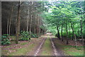
Eileen Roche has been searching for this mound for some years, enlisting the help of the land agent for the Albury estate, from whom permission was gained to visit. Access to the estate is allowed in order to visit the old parish church, via the road at TQ057478. The church is small but interesting, with Turkish inspired architecture and Masonic connections.
From the church, follow the footpath south up the hill to the summit shown on the Explorer maps as 122m. The remains of the mound are about 30m off the path in the bushes to the right. There is not much to see, but we are fairly confident we have located a raised circular area about 10m across with a clump of notably different bushes growing on it.
There are some wonderful old trees over to the east of the estate, making for a lovely walk if not very fulfilling from a prehistoric point of view.
You may be viewing yesterday's version of this page. To see the most up to date information please register for a free account.
")
Do not use the above information on other web sites or publications without permission of the contributor.
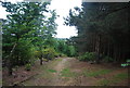
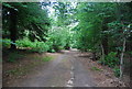
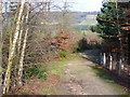
Nearby Images from Geograph Britain and Ireland:
©2012(licence)
©2012(licence)
©2008(licence)
©2012(licence)

©2020(licence)
The above images may not be of the site on this page, they are loaded from Geograph.
Please Submit an Image of this site or go out and take one for us!
Click here to see more info for this site
Nearby sites
Key: Red: member's photo, Blue: 3rd party photo, Yellow: other image, Green: no photo - please go there and take one, Grey: site destroyed
Download sites to:
KML (Google Earth)
GPX (GPS waypoints)
CSV (Garmin/Navman)
CSV (Excel)
To unlock full downloads you need to sign up as a Contributory Member. Otherwise downloads are limited to 50 sites.
Turn off the page maps and other distractions
Nearby sites listing. In the following links * = Image available
1.1km NW 305° Albury Fishponds* Natural Stone / Erratic / Other Natural Feature (TQ053480)
1.1km NNW 332° Weston Woods Cromlech* Standing Stones (TQ05644839)
1.2km N 354° The Silent Pool* Holy Well or Sacred Spring (TQ0606148582)
1.2km NNW 326° Weston Wood Platform Mound* Round Barrow(s) (TQ055484)
2.7km WNW 287° Lid Well* Holy Well or Sacred Spring (TQ03554815)
3.6km WNW 284° St Martha's on the Hill Earth Circles* Misc. Earthwork (TQ027482)
4.2km WNW 287° Tyting Farm Bowl Barrow* Round Barrow(s) (TQ02124857)
5.2km ESE 109° Abinger Manor* Ancient Village or Settlement (TQ112458)
5.3km ESE 121° Felday* Hillfort (TQ10824475)
5.6km E 85° Deerleap Wood* Round Barrow(s) (TQ118480)
6.1km SE 137° Holmbury Camp Hillfort (TQ105430)
6.8km WNW 287° Guildford Museum* Museum (SU9968349258)
6.8km W 278° Artington Spring* Holy Well or Sacred Spring (SU994482)
8.5km ESE 104° Mag's Well (Abinger Forest)* Holy Well or Sacred Spring (TQ145455)
8.6km NW 319° Jacobs Well* Holy Well or Sacred Spring (TQ004538)
8.7km SE 127° Leith Hill Place* Natural Stone / Erratic / Other Natural Feature (TQ1324542344)
9.0km NW 314° Whitmoor Common* Round Barrow(s) (SU996536)
9.2km E 82° Milton Heath* Round Barrow(s) (TQ15294890)
9.7km ESE 112° Anstiebury Camp* Hillfort (TQ1534244008)
10.3km SSW 211° The Dragonstones* Modern Stone Circle etc (TQ0105038489)
10.5km SW 215° Hascombe Hill* Hillfort (TQ004386)
10.8km WSW 242° Lady Well (Tuesley)* Holy Well or Sacred Spring (SU968421)
10.9km E 85° Glory Wood Bowl Barrow* Round Barrow(s) (TQ1712248542)
11.6km N 349° Pyrford Stone* Marker Stone (TQ0382258782)
11.8km N 8° Bowl barrow west of Cockcrow Hill* Round Barrow(s) (TQ07635910)
View more nearby sites and additional images


 We would like to know more about this location. Please feel free to add a brief description and any relevant information in your own language.
 Wir möchten mehr über diese Stätte erfahren. Bitte zögern Sie nicht, eine kurze Beschreibung und relevante Informationen in Deutsch hinzuzufügen.
 Nous aimerions en savoir encore un peu sur les lieux. S'il vous plaît n'hesitez pas à ajouter une courte description et tous les renseignements pertinents dans votre propre langue.
 Quisieramos informarnos un poco más de las lugares. No dude en añadir una breve descripción y otros datos relevantes en su propio idioma.