


<< Our Photo Pages >> Castle Dyke (Devon) - Ancient Village or Settlement in England in Devon
Submitted by coldrum on Tuesday, 31 August 2010 Page Views: 9371
Multi-periodSite Name: Castle Dyke (Devon)Country: England County: Devon Type: Ancient Village or Settlement
Map Ref: SX92147700
Latitude: 50.582743N Longitude: 3.524859W
Condition:
| 5 | Perfect |
| 4 | Almost Perfect |
| 3 | Reasonable but with some damage |
| 2 | Ruined but still recognisable as an ancient site |
| 1 | Pretty much destroyed, possibly visible as crop marks |
| 0 | No data. |
| -1 | Completely destroyed |
| 5 | Superb |
| 4 | Good |
| 3 | Ordinary |
| 2 | Not Good |
| 1 | Awful |
| 0 | No data. |
| 5 | Can be driven to, probably with disabled access |
| 4 | Short walk on a footpath |
| 3 | Requiring a bit more of a walk |
| 2 | A long walk |
| 1 | In the middle of nowhere, a nightmare to find |
| 0 | No data. |
| 5 | co-ordinates taken by GPS or official recorded co-ordinates |
| 4 | co-ordinates scaled from a detailed map |
| 3 | co-ordinates scaled from a bad map |
| 2 | co-ordinates of the nearest village |
| 1 | co-ordinates of the nearest town |
| 0 | no data |
Be the first person to rate this site - see the 'Contribute!' box in the right hand menu.
Internal Links:
External Links:
I have visited· I would like to visit
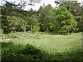
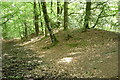
Mabel_Smith visited on 3rd Dec 2018 - their rating: Cond: 2 Amb: 4 Access: 2 The way to go from Bishopsteignton is via the steep public footpath on the corner of Berry Hill and Teignview Road. Follow this path all the way to the road at the top of the hill and go right towards the golf course until you reach the Gypsy Corner sign post, go left on the Exeter road and all the way up passed the golf course until you meet the busy B3192. Carefully continue your route over this crossroads until you come to a small fork, go left to meet Luscombe Hill road and then right along this road a short way until you see a wooden gate through the trees on the left marked 'Eordbirig'. The impressive site stretches out in a dramatic oval enclosure before you, largely clear but for a few tall trees that have seeded themselves in the muddy but flat ground. The Historic England website has this to say on the site, "This monument includes a slight univallate hillfort known as Castle Dyke, situated on the summit of Little Haldon Hill overlooking the valley of Smallacombe Goyle. The hillfort includes an oval enclosure which measures up to 90m long by 76m wide internally, defined by a single rampart bank measuring up to 1.5m high and a partially buried outer ditch which is up to 0.5m deep. To the east is a simple entrance with a causeway over the ditch. The ditch has been cut to the south by a road. The hillfort is referred to as ‘Eordbirig’ in a charter of 1044. Two barrows a short distance east of the hillfort are not included within this scheduling because they have not been formally assessed."
Philip Gourd alleges this about events that took place on Haldon in 927AD in his book 'About Bishopsteigton' printed by Gerald Retallick in 1993, "The situation developed into a pitched battle at the earthworks known as Castle Dyke, within the parish of Bishopsteignton and Haldon. [...] After a sharp conflict here, Athelston completely defeated the Celtic King Howel, and continued the offensive until the Celts retreated to the West of the Tamar. To this day we have Cornwall as a Celtic county and Devon as a Saxon country. What history has been made here at Bishopsteignton!" But unfortunately this publication includes no sources of the information included within so we cannot take this claim that the battle occurred on this site as fact.
 (PID:189256)")
From Pastscape:
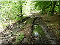
"It is a sub-oval univallate earthwork encompassing 0.73ha. with a bank and outer ditch and traces of a counterscarp bank.
There are two entrances to the unraised interior.
The southern entrance interposes a ditch which is at differing depths on either side. Also here the inner scarp of the bank is of differing lengths. This suggests the gap results from `gang working' and is original.
The north-eastern entrance is flanked by the only traces of the counter scarp bank which suggests it is also original. Recent use of this gap has exposed the stone base of the bank which indicates the entrance was under 3m wide, as is the southern entrance. The earthwork accords with a pre-Norman date. Its situation would suggest a small defensive settlement site probably of I.A. date."
For more information see Pastscape Monument No. 447664.
You may be viewing yesterday's version of this page. To see the most up to date information please register for a free account.
 (PID:189255)")
 (PID:295794)")
 (PID:222531)")
Do not use the above information on other web sites or publications without permission of the contributor.
Nearby Images from Geograph Britain and Ireland:

©2025(licence)

©2025(licence)
©2009(licence)
©2009(licence)
©2009(licence)
The above images may not be of the site on this page, they are loaded from Geograph.
Please Submit an Image of this site or go out and take one for us!
Click here to see more info for this site
Nearby sites
Key: Red: member's photo, Blue: 3rd party photo, Yellow: other image, Green: no photo - please go there and take one, Grey: site destroyed
Download sites to:
KML (Google Earth)
GPX (GPS waypoints)
CSV (Garmin/Navman)
CSV (Excel)
To unlock full downloads you need to sign up as a Contributory Member. Otherwise downloads are limited to 50 sites.
Turn off the page maps and other distractions
Nearby sites listing. In the following links * = Image available
936m SSE 163° Lidwell* Holy Well or Sacred Spring (SX924761)
2.3km SSW 201° Whitewell Woods Well* Holy Well or Sacred Spring (SX913749)
4.9km WNW 289° Castle Dyke (Chudleigh)* Hillfort (SX875787)
5.8km E 79° Langstone Arch* Natural Stone / Erratic / Other Natural Feature (SX9789077950)
5.8km WNW 285° Pixie's Hole* Cave or Rock Shelter (SX86547865)
5.9km WNW 285° Cow Cave* Cave or Rock Shelter (SX86477866)
8.0km SW 222° Newton Abbot Museum* Museum (SX866712)
8.0km SSW 207° Milber Down Camp* Hillfort (SX884699)
8.9km SSW 202° Doda Well* Holy Well or Sacred Spring (SX887688)
9.6km SW 230° Newton Abbot Fort Hillfort (SX846710)
10.2km W 278° St Mary's Well (Bovey Tracey)* Holy Well or Sacred Spring (SX820786)
10.7km SW 215° Ladywell (Abbotskerswell)* Holy Well or Sacred Spring (SX858684)
10.8km W 279° The Bovey Stone Ancient Cross (SX8141778843)
11.0km S 178° Stonehenge at Babbacombe Model Village* Modern Stone Circle etc (SX923660)
11.6km NNE 22° Topsham Museum* Museum (SX9673987646)
11.8km SW 221° Dornafield Tumulus* Round Barrow(s) (SX842682)
12.5km WNW 296° Tottiford Reservoir* Standing Stones (SX810827)
12.6km WNW 298° Tottiford Reservoir Row S* Stone Row / Alignment (SX81138309)
12.6km WNW 298° Tottiford Reservoir cairns* Cairn (SX81138312)
12.6km WNW 298° Tottiford Reservoir mound* Ancient Village or Settlement (SX81118313)
12.6km WNW 298° Tottiford Reservoir circle* Stone Circle (SX81098314)
12.7km WNW 298° Tottiford Reservoir Row N* Stone Row / Alignment (SX81078320)
12.9km SSW 213° Ipplepen Iron Age Settlement* Ancient Village or Settlement (SX848664)
12.9km S 173° Kent's Cavern* Cave or Rock Shelter (SX93456418)
13.0km NW 309° Christow Common Settlement Ancient Village or Settlement (SX82278544)
View more nearby sites and additional images


 We would like to know more about this location. Please feel free to add a brief description and any relevant information in your own language.
 Wir möchten mehr über diese Stätte erfahren. Bitte zögern Sie nicht, eine kurze Beschreibung und relevante Informationen in Deutsch hinzuzufügen.
 Nous aimerions en savoir encore un peu sur les lieux. S'il vous plaît n'hesitez pas à ajouter une courte description et tous les renseignements pertinents dans votre propre langue.
 Quisieramos informarnos un poco más de las lugares. No dude en añadir una breve descripción y otros datos relevantes en su propio idioma.