Featured: Hare and Tabor T Shirts for discerning antiquarians

Hare and Tabor T Shirts for discerning antiquarians

Random Image

Inscribed Across the Landscape: The Cursus Monuments of Great Britain

Inscribed Across the Landscape: The Cursus Monuments of Great Britain

Login

Register here - as a registered user you get more features and fewer ads.

Who's Online

There are currently, 2375 guests and 3 members online.

Sponsors

<< Our Photo Pages >> Dumpdon Great Camp - Hillfort in England in Devon

Submitted by Bladup on Friday, 07 November 2025  Page Views: 18162

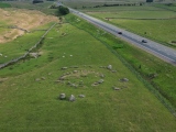
Iron Age and Later PrehistorySite Name: Dumpdon Great Camp
Country: England
NOTE: This site is 2.4 km away from the location you searched for.

County: Devon Type: Hillfort
Nearest Town: Honiton  Nearest Village: Wick
Map Ref: ST176040  Landranger Map Number: 192
Latitude: 50.829649N  Longitude: 3.171369W
Condition:
5Perfect
4Almost Perfect
3Reasonable but with some damage
2Ruined but still recognisable as an ancient site
1Pretty much destroyed, possibly visible as crop marks
0No data.
-1Completely destroyed
4 Ambience:
5Superb
4Good
3Ordinary
2Not Good
1Awful
0No data.
4 Access:
5Can be driven to, probably with disabled access
4Short walk on a footpath
3Requiring a bit more of a walk
2A long walk
1In the middle of nowhere, a nightmare to find
0No data.
4 Accuracy:
5co-ordinates taken by GPS or official recorded co-ordinates
4co-ordinates scaled from a detailed map
3co-ordinates scaled from a bad map
2co-ordinates of the nearest village
1co-ordinates of the nearest town
0no data
4

Internal Links:
External Links:

Dumpdon Great Camp
Dumpdon Great Camp submitted by Bladup : Looking north west over the north western part of the fort (Vote or comment on this photo)
A hillfort located on a detached hill at the southern end of a steep-sided ridge of Upper Greensand between the River Otter and the Luppitt Brook. The flat topped and triangular shaped hillfort of 2.6 hectares was defended by two substantial ramparts and ditches on the northern side, controlling the only easy line of approach, and by single ramparts on the east and west sides.

A single inturned entrance on the north east side provided the only known point of entry. The layout of the defences largely reflects the configuration of the hilltop which is flattest and widest towards its northern end, narrowing down to a steeped point at its southern end.

Read more at Pastscape.
Page originally by Vicky.
You may be viewing yesterday's version of this page. To see the most up to date information please register for a free account.


Dumpdon Great Camp
Dumpdon Great Camp submitted by MattImpey : Great views from the top (1 comment - Vote or comment on this photo)

Dumpdon Great Camp
Dumpdon Great Camp submitted by MattImpey : It has impressive 360 degree views of the whole area. (Vote or comment on this photo)

Dumpdon Great Camp
Dumpdon Great Camp submitted by Bladup : Lidar image of Dumpdon Great Camp Source: www.lidarfinder.com (Vote or comment on this photo)

Dumpdon Great Camp
Dumpdon Great Camp submitted by Bladup : A summers setting sunlight looking north west over the north western part of the fort (Vote or comment on this photo)

Dumpdon Great Camp
Dumpdon Great Camp submitted by Bladup : Northern section looking north

Dumpdon Great Camp
Dumpdon Great Camp submitted by Bladup : The southern tip of the interior of the fort

Dumpdon Great Camp
Dumpdon Great Camp submitted by Bladup : South west side looking north west

Dumpdon Great Camp
Dumpdon Great Camp submitted by Bladup : The south west corner of the fort looking south

Dumpdon Great Camp
Dumpdon Great Camp submitted by Bladup : Outside the east side looking south

Dumpdon Great Camp
Dumpdon Great Camp submitted by Bladup : The south east part of the fort looking south

Dumpdon Great Camp
Dumpdon Great Camp submitted by Bladup : Northern defences looking NE

Dumpdon Great Camp
Dumpdon Great Camp submitted by Bladup : Outside the northern defences of the fort looking west

Dumpdon Great Camp
Dumpdon Great Camp submitted by Bladup : Looking east over the northernmost point of the fort

Dumpdon Great Camp
Dumpdon Great Camp submitted by Bladup : Outside the northern defences

Dumpdon Great Camp
Dumpdon Great Camp submitted by Bladup : Outside the eastern bank

Dumpdon Great Camp
Dumpdon Great Camp submitted by Bladup : Outside the north eastern entrance

Dumpdon Great Camp
Dumpdon Great Camp submitted by Bladup : Looking NW over the north eastern entrance

Dumpdon Great Camp
Dumpdon Great Camp submitted by Bladup : Looking north over the north eastern entrance

Dumpdon Great Camp
Dumpdon Great Camp submitted by Bladup : East side looking SE over a very misty valley

Dumpdon Great Camp
Dumpdon Great Camp submitted by Bladup : west side looking north

Dumpdon Great Camp
Dumpdon Great Camp submitted by Bladup : East side looking south over the misty valley

Dumpdon Great Camp
Dumpdon Great Camp submitted by Bladup : A misty morning looking north over the eastern side of the fort

Dumpdon Great Camp
Dumpdon Great Camp submitted by Bladup : Looking at a summers sunset over the interior of the fort

Dumpdon Great Camp
Dumpdon Great Camp submitted by Bladup : Western bank looking south

These are just the first 25 photos of Dumpdon Great Camp. If you log in with a free user account you will be able to see our entire collection.

Do not use the above information on other web sites or publications without permission of the contributor.
Click here to see more info for this site

Nearby sites

Click here to view sites on an interactive OS map

Key: Red: member's photo, Blue: 3rd party photo, Yellow: other image, Green: no photo - please go there and take one, Grey: site destroyed

Download sites to:
KML (Google Earth)
GPX (GPS waypoints)
CSV (Garmin/Navman)
CSV (Excel)

To unlock full downloads you need to sign up as a Contributory Member. Otherwise downloads are limited to 50 sites.


Turn off the page maps and other distractions

Nearby sites listing. In the following links * = Image available
 4.7km WNW 289° Row Barrow (Devon)* Round Barrow(s) (ST13180561)
 5.2km ESE 104° Stockland Great Castle* Hillfort (ST22620262)
 5.4km E 93° Stockland Little Castle* Hillfort (ST22980362)
 6.3km W 261° Hembury Fort* Hillfort (ST113031)
 8.3km SSW 194° Ring-in-the-Mire* Misc. Earthwork (SY1548695932)
 8.4km SSW 200° Farway & Gittisham Hill Cemetery* Barrow Cemetery (SY146962)
 8.6km S 189° Farway Castle Henge (SY1606395499)
 10.0km S 181° Broad Down* Barrow Cemetery (SY173940)
 10.6km E 96° Membury Castle* Hillfort (ST282028)
 10.7km NNE 34° Robin Hood's Butts South* Barrow Cemetery (ST237128)
 10.7km S 181° Broad Down Stone Circle (SY172933)
 11.6km NNE 27° Robin Hood's Butts North* Barrow Cemetery (ST230143)
 11.7km S 174° Blackbury Camp* Hillfort (SY187924)
 12.1km SE 144° Colyton Church Cross* Ancient Cross (SY24599409)
 12.8km NNE 23° Robin Hoods Butt 2 (Somerset) Round Barrow(s) (ST22801575)
 12.9km NE 53° Northay Barrow* Long Barrow (ST281115)
 13.1km ESE 113° Axminster Castle* Hillfort (SY296986)
 13.4km SSE 168° Hangman's Stone (Seaton)* Standing Stone (Menhir) (SY20279089)
 13.5km SSE 153° Seaton Down Camp* Hillfort (SY23449185)
 13.5km SSW 199° Sidbury Castle* Hillfort (SY129913)
 14.1km SW 224° Belbury Castle Fort Hillfort (SY0758994061)
 14.4km NE 54° Combe Beacon Tumulus* Long Barrow (ST295122)
 14.5km SE 132° Musbury Castle* Hillfort (SY282941)
 15.2km NE 38° Castle Neroche* Hillfort (ST272158)
 15.3km SE 145° Hawksdown Camp* Hillfort (SY26299143)
View more nearby sites and additional images

<< Voley Castle Settlement

Sighthill Park Stone Circle >>

Please add your thoughts on this site

Prehistoric Settlements

Prehistoric Settlements

Sponsors

Latest Visit Logs

  • Badnabay
    “A short walk through rather boggy ground towards the west end of the horseshoe-shaped road coming of…”
    by RingPaw · 7 Jun 2026
  • Tsankawi
    “The complete Tsankawi Village loop trail is about 2 miles round trip. The parking lot is large, pave…”
    by stonetracker · 6 Jun 2026
  • Dun Beag (Struan)
    “Nothing much to add to earlier comments - a short walk but steep in parts. A spectacular site, defin…”
    by Glaschu · 5 Jun 2026
  • Gwal y Filiast
    “Did the anti clockwise circular walk from login, track through field by Dickman (timber merchant) is…”
    by Possumputer · 4 Jun 2026
  • Dun Buidhe
    “Access - it's easy to get to the causeway. You walk across one island which is rough ground but noth…”
    by Glaschu · 3 Jun 2026

"Dumpdon Great Camp" | Login/Create an Account | 4 News and Comments
  
Go back to top of page    Comments are owned by the poster. We aren't responsible for their content.
Re: Dumpdon Great Camp by Anonymous on Sunday, 09 November 2025
The particular shape which Dumpton hill fort conforms is that of a universal nature utilised, in similitude, utilised by many cultures desiring to establish a place of “stability”. This is a citadel, and without divulging its sacred meaning, I suggest those interested to view Jerusalem, and your very own Edinburgh Castle (De Sieur: mound/ seat of the Lord).

Could poor Humpty have been unseated from such a perch of stability?
[ Reply to This ]

A walk along a section of the Neroche Herepath Trail by Andy B on Thursday, 13 October 2011
(User Info | Send a Message)
The Event: A walk along a section of the Neroche Herepath Trail
Dates: 21 Mar 12
Location: Castle Neroche car park

A circular 6.5km/4 mile walk from the Iron Age hill fort of Castle Neroche via the village of Curland. Please note this route can be very muddy following rain.

10am - 1pm

Cost: Free

Location: Castle Neroche car park. Map ref: ST 272 156

For more information: Contact Gill and Jim Thomas on 01404 861 406

Walk level C

Blackdown Hills Walking Group
http://www.blackdownhillsaonb.org.uk/A-walk-along-a-section-of-the-Neroche-Herepath-Trail%E2%80%9321%E2%80%9303%E2%80%932012-Event.htm
[ Reply to This ]

Iron Age experience at Dumpdon by Andy B on Thursday, 13 October 2011
(User Info | Send a Message)
The Event: Iron Age experience at Dumpdon
Dates: 17 Feb 12
Location: Dumpdon Hill, near Honiton

Step back in time at the ancient hill fort of Dumpdon, and try your hand at Iron Age living. The team from Escot Education will show you how to build an Iron Age house, make flour, cook on an open fire, turn wood and dress like a true Iron Age villager! A fun, hands-on way for the whole family to discover the world of the people who built this mysterious hill fort.

10am - 12.30pm

Cost: Adults £5. Under 18s £3. Booking essential. Bus free.

Location: Dumpdon Hill, near Honiton. Free return bus from Lace Walk car park, Honiton EX14 1LT.

For more information: Contact the Blackdown Hills AONB office on 01823 680681 or email [email protected]

Suitable for children over 6. Accessible by public transport

Blackdown Hills AONB & the National Trust
http://www.blackdownhillsaonb.org.uk/Iron-Age-experience-at-Dumpdon%E2%80%9317%E2%80%9302%E2%80%932012-Event.htm
[ Reply to This ]

Dumpdon Hillfort: History and Stargazing, 24th September 2011 by coldrum on Thursday, 22 September 2011
(User Info | Send a Message)
Dumpdon Hillfort: History and Stargazing

Saturday, 24 September 2011 7pm - 9pm free bus from Honiton 6.30pm
Adult £6, Child £4 (10yrs to under 16 yrs)

An atmospheric evening combining history and stargazing


Join archaeologist Hazel Riley who will guide you through the Iron Age past of this ancient hillfort on a dusk walk. Once at the top, astronomer Simon Ould will take over as it gets dark and take you on a tour of the night sky.

# Booking Essential 01823 681933
Please book through Katherine Morgan, Blackdown Hills AONB Information Officer
# Please bring a torch, your own telescope if you have one, wear some warm cloths and bring a hot drink if you wish.
# We will be meeting at Dumpdon Hillfort National Trust car park. To avoid overcrowding there will be a free bus operating from Lace Walk car park, Honiton. EX14 1LT
# Children over 10 years old welcome
# We encourage you to use the free bus service which will be running from Honiton. This event is being run in assocation with the Blackdown Hills AONB
# We will be walking approximately 3 miles

http://www.nationaltrust.org.uk/main/w-eastdevonjurassiccoast
[ Reply to This ]

Your Name: Anonymous [ Register Now ]
Subject:


Add your comment or contribution to this page. Spam or offensive posts are deleted immediately, don't even bother

<<< What is five plus one as a number? (Please type the answer to this question in the little box on the left)
You can also embed videos and other things. For Youtube please copy and paste the 'embed code'.
For Google Street View please include Street View in the text.
Create a web link like this: <a href="https://www.megalithic.co.uk">This is a link</a>  

Allowed HTML is:
<p> <b> <i> <a> <img> <em> <br> <strong> <blockquote> <tt> <li> <ol> <ul> <object> <param> <embed> <iframe>

We would like to know more about this location. Please feel free to add a brief description and any relevant information in your own language.
Wir möchten mehr über diese Stätte erfahren. Bitte zögern Sie nicht, eine kurze Beschreibung und relevante Informationen in Deutsch hinzuzufügen.
Nous aimerions en savoir encore un peu sur les lieux. S'il vous plaît n'hesitez pas à ajouter une courte description et tous les renseignements pertinents dans votre propre langue.
Quisieramos informarnos un poco más de las lugares. No dude en añadir una breve descripción y otros datos relevantes en su propio idioma.