 with our Megalithic Portal iPhone app")


<< Our Photo Pages >> Yelland - Multiple Stone Rows / Avenue in England in Devon
Submitted by archaeologyh on Wednesday, 04 February 2004 Page Views: 22229
Neolithic and Bronze AgeSite Name: Yelland Alternative Name: Isley Marsh Stone RowCountry: England
NOTE: This site is 2.5 km away from the location you searched for.
County: Devon Type: Multiple Stone Rows / Avenue
Nearest Town: Barnstable / Bideford Nearest Village: Yelland
Map Ref: SS4912532889 Landranger Map Number: 180
Latitude: 51.075438N Longitude: 4.155062W
Condition:
| 5 | Perfect |
| 4 | Almost Perfect |
| 3 | Reasonable but with some damage |
| 2 | Ruined but still recognisable as an ancient site |
| 1 | Pretty much destroyed, possibly visible as crop marks |
| 0 | No data. |
| -1 | Completely destroyed |
| 5 | Superb |
| 4 | Good |
| 3 | Ordinary |
| 2 | Not Good |
| 1 | Awful |
| 0 | No data. |
| 5 | Can be driven to, probably with disabled access |
| 4 | Short walk on a footpath |
| 3 | Requiring a bit more of a walk |
| 2 | A long walk |
| 1 | In the middle of nowhere, a nightmare to find |
| 0 | No data. |
| 5 | co-ordinates taken by GPS or official recorded co-ordinates |
| 4 | co-ordinates scaled from a detailed map |
| 3 | co-ordinates scaled from a bad map |
| 2 | co-ordinates of the nearest village |
| 1 | co-ordinates of the nearest town |
| 0 | no data |
Internal Links:
External Links:
I have visited· I would like to visit
hallsifer would like to visit
lauraaurora visited - their rating: Amb: 4 Access: 3
")
E.H. Rogers standing at the end of The Yelland Multiple Stone Row (approx 1932). The site is now covered by tidal silt and is located within the RSPB nature reserve of Isley Marsh.
Update August 2019: This stone row is recorded on the Stone Rows of Great Britain website - see their entry for the Yelland Stone Row, which includes a description, a photograph and a plan of the row. SRoGB tells us the row is 34.5m long, and comprises 22 small and medium stones.
The row is also recorded as Pastcape Monument No. 33321, which adds "(this is a) double stone row partly in (a) tidal area)", and scheduled as Historic England List ID 1003847 (Double stone alignment on Isley Marsh 535m north of Lower Yelland Farm).
Note: The stone rows are by a river and should be visited at low tide.
You may be viewing yesterday's version of this page. To see the most up to date information please register for a free account.
")
")
Do not use the above information on other web sites or publications without permission of the contributor.
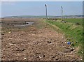
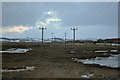
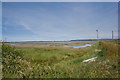
Nearby Images from Geograph Britain and Ireland:
©2007(licence)
©2010(licence)
©2019(licence)

©2025(licence)

©2025(licence)
The above images may not be of the site on this page, they are loaded from Geograph.
Please Submit an Image of this site or go out and take one for us!
Click here to see more info for this site
Nearby sites
Key: Red: member's photo, Blue: 3rd party photo, Yellow: other image, Green: no photo - please go there and take one, Grey: site destroyed
Download sites to:
KML (Google Earth)
GPX (GPS waypoints)
CSV (Garmin/Navman)
CSV (Excel)
To unlock full downloads you need to sign up as a Contributory Member. Otherwise downloads are limited to 50 sites.
![]()
Turn off the page maps and other distractions
Nearby sites listing. In the following links * = Image available
4.5km N 353° St. Brannoc's Holy Well (Braunton)* Holy Well or Sacred Spring (SS487374)
5.4km N 355° Knowle Castle* Hillfort (SS488383)
5.5km E 90° Dripping Well (Barnstaple)* Holy Well or Sacred Spring (SS546327)
6.3km ENE 76° Pilton Long Stone* Standing Stone (Menhir) (SS55313421)
6.6km ENE 77° Ladywell (Pilton)* Holy Well or Sacred Spring (SS556342)
6.7km E 88° Museum of Barnstaple and North Devon* Museum (SS5586732983)
6.9km ESE 115° Holy Well (Tawstock)* Holy Well or Sacred Spring (SS553298)
7.1km WSW 239° Shell Middens at Westward Ho!* Ancient Village or Settlement (SS429294)
7.7km NW 321° St Helen's Well (Croyde)* Holy Well or Sacred Spring (SS4440538970)
8.1km ENE 72° Burridge Camp* Ancient Village or Settlement (SS569352)
8.7km N 353° Spreacombe Fort Hillfort (SS4823641585)
9.6km NW 323° Baggy Point erratic* Natural Stone / Erratic / Other Natural Feature (SS4356540705)
10.3km ENE 56° Plaistow Enclosure* Ancient Village or Settlement (SS5793038350)
10.6km S 176° Berry Castle (Huntshaw Wood)* Hillfort (SS49502228)
11.1km NNE 26° Centery Farm Tumuli* Barrow Cemetery (SS543427)
11.6km NNW 340° Woolacombe Memorial* Modern Stone Circle etc (SS45494389)
11.9km NNW 345° Greystone* Standing Stone (Menhir) (SS46354443)
11.9km NNW 344° The Konk Stone* Standing Stone (Menhir) (SS4620044400)
12.7km ENE 70° Cunnilear Hillfort Hillfort (SS61283680)
13.0km NNW 344° North Morte Well* Holy Well or Sacred Spring (SS459455)
13.2km NE 34° Berry Down Barrows* Barrow Cemetery (SS5690043600)
13.2km N 0° Whitestone (Lee)* Standing Stone (Menhir) (SS49564613)
13.3km S 181° Coverney Well* Holy Well or Sacred Spring (SS484196)
13.4km N 349° Damage Barton* Standing Stones (SS47044615)
13.6km N 350° Damage Barton 2* Standing Stone (Menhir) (SS47064633)
View more nearby sites and additional images


 We would like to know more about this location. Please feel free to add a brief description and any relevant information in your own language.
 Wir möchten mehr über diese Stätte erfahren. Bitte zögern Sie nicht, eine kurze Beschreibung und relevante Informationen in Deutsch hinzuzufügen.
 Nous aimerions en savoir encore un peu sur les lieux. S'il vous plaît n'hesitez pas à ajouter une courte description et tous les renseignements pertinents dans votre propre langue.
 Quisieramos informarnos un poco más de las lugares. No dude en añadir una breve descripción y otros datos relevantes en su propio idioma.