


<< Other Photo Pages >> Groes Fawr Cairn - Round Cairn in Wales in Ceredigion
Submitted by Andy B on Tuesday, 04 July 2023 Page Views: 207
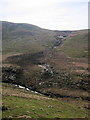
Neolithic and Bronze AgeSite Name: Groes Fawr CairnCountry: Wales County: Ceredigion Type: Round Cairn
Nearest Village: Tregaron
Map Ref: SN7273059860
Latitude: 52.222199N Longitude: 3.864566W
Condition:
| 5 | Perfect |
| 4 | Almost Perfect |
| 3 | Reasonable but with some damage |
| 2 | Ruined but still recognisable as an ancient site |
| 1 | Pretty much destroyed, possibly visible as crop marks |
| 0 | No data. |
| -1 | Completely destroyed |
| 5 | Superb |
| 4 | Good |
| 3 | Ordinary |
| 2 | Not Good |
| 1 | Awful |
| 0 | No data. |
| 5 | Can be driven to, probably with disabled access |
| 4 | Short walk on a footpath |
| 3 | Requiring a bit more of a walk |
| 2 | A long walk |
| 1 | In the middle of nowhere, a nightmare to find |
| 0 | No data. |
| 5 | co-ordinates taken by GPS or official recorded co-ordinates |
| 4 | co-ordinates scaled from a detailed map |
| 3 | co-ordinates scaled from a bad map |
| 2 | co-ordinates of the nearest village |
| 1 | co-ordinates of the nearest town |
| 0 | no data |
Internal Links:
External Links:
")
A round cairn, 6.0m in diameter, showing a cist, 1.5m by 1.0m, roofed to form a shelter, apparently attached to a further cairn, c.10m by 6.0m; there are remains of sheepfold to SW (second cairn?).
Source: Coflein
You may be viewing yesterday's version of this page. To see the most up to date information please register for a free account.
")
")
")
Do not use the above information on other web sites or publications without permission of the contributor.
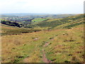
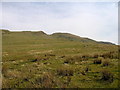
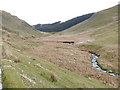
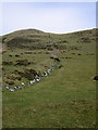
Nearby Images from Geograph Britain and Ireland:
©2019(licence)
©2010(licence)
©2008(licence)
©2010(licence)
©2010(licence)
The above images may not be of the site on this page, they are loaded from Geograph.
Please Submit an Image of this site or go out and take one for us!
Click here to see more info for this site
Nearby sites
Key: Red: member's photo, Blue: 3rd party photo, Yellow: other image, Green: no photo - please go there and take one, Grey: site destroyed
Download sites to:
KML (Google Earth)
GPX (GPS waypoints)
CSV (Garmin/Navman)
CSV (Excel)
To unlock full downloads you need to sign up as a Contributory Member. Otherwise downloads are limited to 50 sites.
Turn off the page maps and other distractions
Nearby sites listing. In the following links * = Image available
469m E 87° Castell Rhyfel Hillfort (SN7320059870)
2.6km ESE 110° Blaen Camddwr Cairn* Cairn (SN7516558906)
3.8km ESE 113° Nant-Y-Maen Stone* Standing Stone (Menhir) (SN76175830)
4.0km W 273° Castell Tregaron* Hillfort (SN6869760188)
4.2km ESE 115° Cefn Cerrig* Cairn (SN76465801)
4.3km ESE 109° Cefn Cerrig Cairn/Round Barrow* Round Barrow(s) (SN7673258333)
4.6km W 271° Tregaron Gorsedd Circle* Modern Stone Circle etc (SN6807860037)
4.7km E 101° Cefn y Cnuc Cairn* Cairn (SN7731658859)
5.3km NE 37° Glasffrwyd Holy Well* Holy Well or Sacred Spring (SN75996399)
5.3km NE 51° Blaen Glas ffrwd Standing Stone Standing Stone (Menhir) (SN769631)
5.4km NE 52° Blaen Glasffrwd Cairn Field Cairn (SN771631)
5.6km SSE 155° Bryn y Gorlan* Stone Circle (SN74945473)
5.8km NNE 28° Ffynnon Llygaid (Drefach)* Holy Well or Sacred Spring (SN7564064940)
6.2km NNE 16° Strata Florida Sculptured Stone* Early Christian Sculptured Stone (SN74646577)
6.3km NE 49° Pen-Y-Bwlch W ,Cairn Cairn (SN776638)
6.5km NE 52° Pen-Y-Bwlch E ,Cairn Cairn (SN780637)
7.2km N 10° Pen-y-Bannau* Hillfort (SN74196689)
7.4km NNE 28° Troed Y Rhiw 2 Cairn (SN76336634)
7.5km SSE 146° Blaen nant y Rhiw Round Cairn* Cairn (SN76765347)
7.8km SW 233° St David (Llandewi Brefi)* Ancient Cross (SN66385531)
7.9km ESE 107° Eagair Gerwyn Cairn Cemetary* Cairn (SN80265736)
7.9km SW 219° Careg Samson* Standing Stone (Menhir) (SN67575384)
8.0km WNW 293° Castell Flemish* Hillfort (SN6538863195)
8.1km SE 146° Carn Saith-Wraig, Ring Cairn* Ring Cairn (SN77105297)
8.3km SE 146° Carn Saith-Wraig, Round Cairn* Round Cairn (SN77185288)
View more nearby sites and additional images


 We would like to know more about this location. Please feel free to add a brief description and any relevant information in your own language.
 Wir möchten mehr über diese Stätte erfahren. Bitte zögern Sie nicht, eine kurze Beschreibung und relevante Informationen in Deutsch hinzuzufügen.
 Nous aimerions en savoir encore un peu sur les lieux. S'il vous plaît n'hesitez pas à ajouter une courte description et tous les renseignements pertinents dans votre propre langue.
 Quisieramos informarnos un poco más de las lugares. No dude en añadir una breve descripción y otros datos relevantes en su propio idioma.