 with our Megalithic Portal iPhone app")


<< Our Photo Pages >> Hermit's Well (Dale Abbey) - Holy Well or Sacred Spring in England in Derbyshire
Submitted by TimPrevett on Tuesday, 29 May 2007 Page Views: 5633
Springs and Holy WellsSite Name: Hermit's Well (Dale Abbey)Country: England
NOTE: This site is 3.4 km away from the location you searched for.
County: Derbyshire Type: Holy Well or Sacred Spring
Nearest Town: Spondon
Map Ref: SK43783861
Latitude: 52.943101N Longitude: 1.34996W
Condition:
| 5 | Perfect |
| 4 | Almost Perfect |
| 3 | Reasonable but with some damage |
| 2 | Ruined but still recognisable as an ancient site |
| 1 | Pretty much destroyed, possibly visible as crop marks |
| 0 | No data. |
| -1 | Completely destroyed |
| 5 | Superb |
| 4 | Good |
| 3 | Ordinary |
| 2 | Not Good |
| 1 | Awful |
| 0 | No data. |
| 5 | Can be driven to, probably with disabled access |
| 4 | Short walk on a footpath |
| 3 | Requiring a bit more of a walk |
| 2 | A long walk |
| 1 | In the middle of nowhere, a nightmare to find |
| 0 | No data. |
| 5 | co-ordinates taken by GPS or official recorded co-ordinates |
| 4 | co-ordinates scaled from a detailed map |
| 3 | co-ordinates scaled from a bad map |
| 2 | co-ordinates of the nearest village |
| 1 | co-ordinates of the nearest town |
| 0 | no data |
Be the first person to rate this site - see the 'Contribute!' box in the right hand menu.
Internal Links:
External Links:
 (PID:298797)")
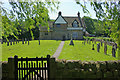
The Hermit's Well at Dale Abbey features on The Northern Antiquarian's page for Hermit’s Well, Dale Abbey, Derbyshire. TNA give directions for finding the well, which lies within the private garden of Church House, although it can be seen in winter from the footpath below the church, as well as from the churchyard.
TNA include photographs, a brief archaeology & history and local folklore, this saying that the waters of the well were curative and that it was a wising well: "being visited on Good Friday, between twelve and three o’clock, water being drunk three times."
Note: Have you visited this site? Do you have any photographs or information to add?
You may be viewing yesterday's version of this page. To see the most up to date information please register for a free account.
Do not use the above information on other web sites or publications without permission of the contributor.
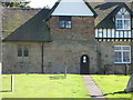
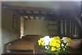
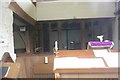
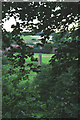
Nearby Images from Geograph Britain and Ireland:
©2008(licence)
©2011(licence)
©2011(licence)
©2008(licence)
©2009(licence)
The above images may not be of the site on this page, they are loaded from Geograph.
Please Submit an Image of this site or go out and take one for us!
Click here to see more info for this site
Nearby sites
Key: Red: member's photo, Blue: 3rd party photo, Yellow: other image, Green: no photo - please go there and take one, Grey: site destroyed
Download sites to:
KML (Google Earth)
GPX (GPS waypoints)
CSV (Garmin/Navman)
CSV (Excel)
To unlock full downloads you need to sign up as a Contributory Member. Otherwise downloads are limited to 50 sites.
Turn off the page maps and other distractions
Nearby sites listing. In the following links * = Image available
988m SW 232° Dale Hermitage* Cave or Rock Shelter (SK4338)
4.8km WSW 236° St Werburgh (Spondon)* Ancient Cross (SK39793592)
5.2km WNW 298° Morley Moated Mound* Round Barrow(s) (SK392410)
5.2km SW 227° Saxon Holy Well* Holy Well or Sacred Spring (SK4035)
5.3km ESE 105° Stapleford Cross* Ancient Cross (SK489373)
5.6km E 87° Healing Spring* Holy Well or Sacred Spring (SK494390)
5.6km ESE 104° Bob's Rock* Rock Outcrop (SK4927937319)
6.2km E 90° The Hemlock Stone* Rock Outcrop (SK4995538661)
6.6km E 95° Crow Hill Standing Stone* Standing Stone (Menhir) (SK50403805)
7.5km ENE 68° Catstone Hill* Natural Stone / Erratic / Other Natural Feature (SK50754156)
8.7km S 188° Aston Cursus Cursus (SK426300)
8.7km W 260° Saint Alkmund's Well* Holy Well or Sacred Spring (SK35173703)
8.9km SE 125° Conies Farm Stone Circle* Stone Circle (SK5115033599)
8.9km W 259° Little Chester Roman Wells* Holy Well or Sacred Spring (SK350369)
8.9km SSE 154° Sawley earthwork* Misc. Earthwork (SK4781130639)
9.0km WSW 255° Derby Museum and Art Gallery* Museum (SK3509236220)
9.3km NE 42° Holy Well (Watnall)* Holy Well or Sacred Spring (SK499456)
10.3km SSW 192° Aston Cursus Cursus (SK417285)
10.4km SSE 163° Lockington Cursus Cursus (SK469287)
10.4km SSW 193° Aston Cursus Cursus (SK416284)
10.8km ESE 115° Cliffton Woods Well* Holy Well or Sacred Spring (SK5361134124)
11.6km ESE 104° Clifton Pile Settlements* Ancient Village or Settlement (SK5513735946)
11.6km SW 219° Swarkestone Lows* Barrow Cemetery (SK365295)
12.1km NW 316° Lady Well (Belper) Holy Well or Sacred Spring (SK353472)
12.1km NNE 30° Robin Hood's Well (Beauvale)* Holy Well or Sacred Spring (SK49684915)
View more nearby sites and additional images


 We would like to know more about this location. Please feel free to add a brief description and any relevant information in your own language.
 Wir möchten mehr über diese Stätte erfahren. Bitte zögern Sie nicht, eine kurze Beschreibung und relevante Informationen in Deutsch hinzuzufügen.
 Nous aimerions en savoir encore un peu sur les lieux. S'il vous plaît n'hesitez pas à ajouter une courte description et tous les renseignements pertinents dans votre propre langue.
 Quisieramos informarnos un poco más de las lugares. No dude en añadir una breve descripción y otros datos relevantes en su propio idioma.