 with our Megalithic Portal iPhone app")


<< Our Photo Pages >> St Ruffin's Well (Tamworth) - Holy Well or Sacred Spring in England in Staffordshire
Submitted by TimPrevett on Tuesday, 10 September 2024 Page Views: 14214
Springs and Holy WellsSite Name: St Ruffin's Well (Tamworth) Alternative Name: Tamworth CastleCountry: England
NOTE: This site is 2.5 km away from the location you searched for.
County: Staffordshire Type: Holy Well or Sacred Spring
Nearest Town: Tamworth
Map Ref: SK207038
Latitude: 52.631563N Longitude: 1.695593W
Condition:
| 5 | Perfect |
| 4 | Almost Perfect |
| 3 | Reasonable but with some damage |
| 2 | Ruined but still recognisable as an ancient site |
| 1 | Pretty much destroyed, possibly visible as crop marks |
| 0 | No data. |
| -1 | Completely destroyed |
| 5 | Superb |
| 4 | Good |
| 3 | Ordinary |
| 2 | Not Good |
| 1 | Awful |
| 0 | No data. |
| 5 | Can be driven to, probably with disabled access |
| 4 | Short walk on a footpath |
| 3 | Requiring a bit more of a walk |
| 2 | A long walk |
| 1 | In the middle of nowhere, a nightmare to find |
| 0 | No data. |
| 5 | co-ordinates taken by GPS or official recorded co-ordinates |
| 4 | co-ordinates scaled from a detailed map |
| 3 | co-ordinates scaled from a bad map |
| 2 | co-ordinates of the nearest village |
| 1 | co-ordinates of the nearest town |
| 0 | no data |
Internal Links:
External Links:
I have visited· I would like to visit
BrownEdger would like to visit
 (PID:87047)")
Their grave, set up by their mother, gave the name to the town of Stone.
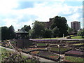
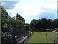
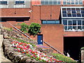
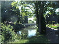
TimPrevett adds: The Historic England entry suggests the holy well remains within the main fabric of Tamworth castle (grid ref SK20620392); however, the castle staff dug in a book, knowing nothing of the holy well when I enquired. The book shows a holy well on the lower terraces in what would have been the bailey of the castle. What survives there today does not resemble the picture in the book; indeed, one wonders if the issue of water, or any structure survives, in spite of there being a commemorative plaque amongst raised flower beds on the south west exterior of the Ankerside Shopping Centre, on the lowest level near the river. This is consistent with the location displayed on the DEFRA MAGIC Map at SK 207 038.
Another St Ruffin's Well is purportedly situated to the south east of Stone.
You may be viewing yesterday's version of this page. To see the most up to date information please register for a free account.
 (PID:33467)")
 (PID:33466)")
Do not use the above information on other web sites or publications without permission of the contributor.
Nearby Images from Geograph Britain and Ireland:
©2008(licence)
©2008(licence)
©2008(licence)
©2008(licence)
©2008(licence)
The above images may not be of the site on this page, they are loaded from Geograph.
Please Submit an Image of this site or go out and take one for us!
Click here to see more info for this site
Nearby sites
Key: Red: member's photo, Blue: 3rd party photo, Yellow: other image, Green: no photo - please go there and take one, Grey: site destroyed
Download sites to:
KML (Google Earth)
GPX (GPS waypoints)
CSV (Garmin/Navman)
CSV (Excel)
To unlock full downloads you need to sign up as a Contributory Member. Otherwise downloads are limited to 50 sites.
Turn off the page maps and other distractions
Nearby sites listing. In the following links * = Image available
6.6km WSW 241° St Modwen's Well (Canwell) Holy Well or Sacred Spring (SK14890058)
8.4km N 5° Stone in Croxall Churchyard* Marker Stone (SK2140512127)
10.7km NW 308° St Chad's Well (Lichfield)* Holy Well or Sacred Spring (SK122103)
11.0km N 349° National Memorial Arboretum* Henge (SK18531459)
11.3km WNW 285° Wall Roman sites (Letocetum)* Ancient Village or Settlement (SK0977506660)
11.5km NNW 345° Alrewas Cursus* Cursus (SK177149)
11.5km NNW 345° Alrewas and Fradley Cursus Cursus (SK177149)
11.8km NNW 333° Alrewas Causewayed Enclosure* Causewayed Enclosure (SK15351436)
12.0km WSW 241° Druid's Well (Sutton Park) Holy Well or Sacred Spring (SP1016297991)
12.5km SW 235° Keeper's Well* Holy Well or Sacred Spring (SP1049296613)
12.9km N 355° Catholme 01* Timber Circle (SK19621666)
13.0km N 355° Catholme 02 Henge (SK19431670)
13.2km N 354° Barton Under Needwood Cursus Cursus (SK19301697)
13.5km N 355° Efflinch Cursus (SK19521724)
13.5km WSW 238° Rowton Well* Holy Well or Sacred Spring (SP0927496487)
14.0km S 185° Beggars Well* Holy Well or Sacred Spring (SP1962989822)
14.0km SE 131° Oldbury Camp (Warwickshire)* Hillfort (SP3140094700)
14.3km SE 136° Ansley Common Round Barrow(s) (SP307935)
15.0km NW 323° King's Bromley Cursus Cursus (SK116157)
15.1km WSW 237° The King's Standing* Round Barrow(s) (SP080956)
15.5km S 186° Coleshill Bridge* Ancient Village or Settlement (SP191884)
16.2km ESE 114° Fenny Drayton Barrow* Round Barrow(s) (SP356973)
17.4km NE 41° Blackfordby Spring* Holy Well or Sacred Spring (SK3217)
17.8km NW 317° Mavesyn Ridware* Causewayed Enclosure (SK0853816800)
18.3km WNW 296° Nun's Well (Cannock Wood)* Holy Well or Sacred Spring (SK04151180)
View more nearby sites and additional images


 We would like to know more about this location. Please feel free to add a brief description and any relevant information in your own language.
 Wir möchten mehr über diese Stätte erfahren. Bitte zögern Sie nicht, eine kurze Beschreibung und relevante Informationen in Deutsch hinzuzufügen.
 Nous aimerions en savoir encore un peu sur les lieux. S'il vous plaît n'hesitez pas à ajouter une courte description et tous les renseignements pertinents dans votre propre langue.
 Quisieramos informarnos un poco más de las lugares. No dude en añadir una breve descripción y otros datos relevantes en su propio idioma.