


<< Our Photo Pages >> Shitlington - Marker Stone in England in Northumberland
Submitted by Anne T on Saturday, 27 May 2017 Page Views: 2171
Multi-periodSite Name: ShitlingtonCountry: England
NOTE: This site is 0.3 km away from the location you searched for.
County: Northumberland Type: Marker Stone
Nearest Town: Bellingham
Map Ref: NY8188879790
Latitude: 55.112175N Longitude: 2.285462W
Condition:
| 5 | Perfect |
| 4 | Almost Perfect |
| 3 | Reasonable but with some damage |
| 2 | Ruined but still recognisable as an ancient site |
| 1 | Pretty much destroyed, possibly visible as crop marks |
| 0 | No data. |
| -1 | Completely destroyed |
| 5 | Superb |
| 4 | Good |
| 3 | Ordinary |
| 2 | Not Good |
| 1 | Awful |
| 0 | No data. |
| 5 | Can be driven to, probably with disabled access |
| 4 | Short walk on a footpath |
| 3 | Requiring a bit more of a walk |
| 2 | A long walk |
| 1 | In the middle of nowhere, a nightmare to find |
| 0 | No data. |
| 5 | co-ordinates taken by GPS or official recorded co-ordinates |
| 4 | co-ordinates scaled from a detailed map |
| 3 | co-ordinates scaled from a bad map |
| 2 | co-ordinates of the nearest village |
| 1 | co-ordinates of the nearest town |
| 0 | no data |
Internal Links:
External Links:
I have visited· I would like to visit
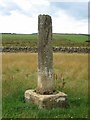
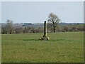
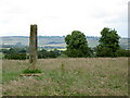
Anne T visited on 25th May 2017 - their rating: Cond: 3 Amb: 4 Access: 4 Shitlington Cross, near Bridge House (south of Bellingham): We stopped here because we were passing on the way to the Bridge House/Hetherington Farm homestead and it was marked on the OS map as a ‘cross’. It looks like an old standing stone on a sandstone cross base, similar to the Hurl Stone near Ewe Hill/Lilburn Grange (http://www.megalithic.co.uk/article.php?sid=35235but with a genuinely older base (not just reset in concrete).
Someone had made a stile over the wall into the field. As this was just pasture, we kept to the edge of the field to have a closer look. Very enigmatic, just sitting in the middle of the field with nothing around it.
Checked the top – there was no socket on top, just weathered. It was worth stopping to look because of the wonderful views over Watergate Moor, Wark Common and Broughy’s Hill. Could have sat here all day in the sunshine.
")
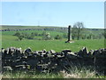
Driving across Watergate Moor from Bellingham, more or less following Cycle Route 68, as you approach Bridge House a solitary cross shaft appears above the stone walls on your left hand side (it is marked on the OS map). There is a large passing-place/layby where Pundershaw Burn is piped under the road, some 100 metres passed the cross. A stile has been provided over the stone wall about 15 metres back along the road, giving access into the field, which was put to pasture at the time of our visit.
Coming closer to the cross, it looks as if the shaft and base don't belong to each other. The shaft is reminiscent of a shorter version of the Hurl Stone, but mounted on an old sandstone base rather than set into modern-day concrete, although the cross shaft has champfered sides.
Pastscape Monument No. 16566 tells us that this is the "remains of a medieval wayside cross of which the stepped socket stone survives. Alleged site of Shitlington deserted medieval village, no earthwork remains ..... The cross is visible as a socket stone measuring 0.79m by 0.74m with a worn step; it is well embedded in the ground but stands to a height of 0.38m above ground level. There is a central socket hole in which stands a stone shaft 0.4m by 0.35m and 1.8m high with its top broken off. The shaft has wide chamfered edges."
Historic England List Entry 1370440 records that this is a sandstone cross shaft and base ...... octagonal shaft c 7ft on square base."
We checked to see if there was a socket on the top of the cross shaft, but there was only weathering and lichen. This is much more reminiscent of a broken preaching cross, being placed where it is in the middle of moorland, and no trace left of any surrounding village.
You may be viewing yesterday's version of this page. To see the most up to date information please register for a free account.
")
")
Do not use the above information on other web sites or publications without permission of the contributor.
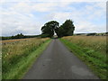
Nearby Images from Geograph Britain and Ireland:
©2019(licence)
©2009(licence)
©2021(licence)
©2007(licence)
©2019(licence)
The above images may not be of the site on this page, they are loaded from Geograph.
Please Submit an Image of this site or go out and take one for us!
Click here to see more info for this site
Nearby sites
Key: Red: member's photo, Blue: 3rd party photo, Yellow: other image, Green: no photo - please go there and take one, Grey: site destroyed
Download sites to:
KML (Google Earth)
GPX (GPS waypoints)
CSV (Garmin/Navman)
CSV (Excel)
To unlock full downloads you need to sign up as a Contributory Member. Otherwise downloads are limited to 50 sites.
Turn off the page maps and other distractions
Nearby sites listing. In the following links * = Image available
1.0km SE 144° Hetherington (Wark)* Ancient Village or Settlement (NY8248378964)
3.1km N 4° Crag Well (Bellingham)* Holy Well or Sacred Spring (NY8212282858)
3.1km E 101° Houxty Cottage (Wark) Rock Art (NY8493279174)
3.3km SSW 210° Holy Well (Stonehaugh) Holy Well or Sacred Spring (NY8023076960)
3.9km NNE 27° St Cuthbert's Well (Bellingham)* Holy Well or Sacred Spring (NY837833)
4.0km ENE 63° Whitewall Nook Enclosure Ancient Village or Settlement (NY855816)
4.2km E 91° Lee Hall Well (Bellingham) Holy Well or Sacred Spring (NY861797)
4.4km E 95° High Carry House (Birtley) Rock Art (NY8629079410)
4.6km N 9° Reenes Farm Rock Art (NY8266084340)
5.0km E 97° Carry House Enclosure (Birtley Shields)* Ancient Village or Settlement (NY86877920)
5.0km ENE 59° Redesmouth Settlement Ancient Village or Settlement (NY862824)
5.1km SSE 167° Goatstones 6 Rock Art (NY8303574800)
5.1km SSE 164° Goatstones B* Rock Art (NY8327274844)
5.1km SSE 163° Goatstones i Rock Art (NY8333574861)
5.1km SSE 164° Goatstones C* Rock Art (NY8330274835)
5.2km SSE 165° Goatstones 8 Rock Art (NY8323174808)
5.2km SSE 165° Goatstones D* Rock Art (NY8324474808)
5.2km SSE 165° Goatstones 12 Rock Art (NY8323074799)
5.2km SSE 165° Goatstones E* Rock Art (NY8323074798)
5.2km SSE 162° Goatstones H* Rock Art (NY8347774870)
5.2km SSE 165° Goatstones 10 Rock Art (NY8324174798)
5.2km SSE 162° Goatstones F.* Rock Art (NY8347674867)
5.2km SSE 162° Goatstones G* Rock Art (NY8346974863)
5.2km SSE 162° Goatstones 27 Rock Art (NY8346474860)
5.2km SSE 168° Goatstones Four-Poster* Stone Circle (NY8294074709)
View more nearby sites and additional images


 We would like to know more about this location. Please feel free to add a brief description and any relevant information in your own language.
 Wir möchten mehr über diese Stätte erfahren. Bitte zögern Sie nicht, eine kurze Beschreibung und relevante Informationen in Deutsch hinzuzufügen.
 Nous aimerions en savoir encore un peu sur les lieux. S'il vous plaît n'hesitez pas à ajouter une courte description et tous les renseignements pertinents dans votre propre langue.
 Quisieramos informarnos un poco más de las lugares. No dude en añadir una breve descripción y otros datos relevantes en su propio idioma.