

<< Our Photo Pages >> Airlich Stone Circle - Stone Circle in Scotland in Perth and Kinross
Submitted by Bladup on Monday, 11 November 2002 Page Views: 10611
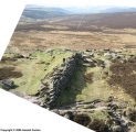
Neolithic and Bronze AgeSite Name: Airlich Stone CircleCountry: Scotland County: Perth and Kinross Type: Stone Circle
Map Ref: NN9590838678 Landranger Map Number: 52
Latitude: 56.528561N Longitude: 3.69382W
Condition:
| 5 | Perfect |
| 4 | Almost Perfect |
| 3 | Reasonable but with some damage |
| 2 | Ruined but still recognisable as an ancient site |
| 1 | Pretty much destroyed, possibly visible as crop marks |
| 0 | No data. |
| -1 | Completely destroyed |
| 5 | Superb |
| 4 | Good |
| 3 | Ordinary |
| 2 | Not Good |
| 1 | Awful |
| 0 | No data. |
| 5 | Can be driven to, probably with disabled access |
| 4 | Short walk on a footpath |
| 3 | Requiring a bit more of a walk |
| 2 | A long walk |
| 1 | In the middle of nowhere, a nightmare to find |
| 0 | No data. |
| 5 | co-ordinates taken by GPS or official recorded co-ordinates |
| 4 | co-ordinates scaled from a detailed map |
| 3 | co-ordinates scaled from a bad map |
| 2 | co-ordinates of the nearest village |
| 1 | co-ordinates of the nearest town |
| 0 | no data |
Internal Links:
External Links:
I have visited· I would like to visit
DrewParsons would like to visit
Bladup has visited here
")
Have you visited this site? Please contribute a description or any thoughts by adding a comment.
You may be viewing yesterday's version of this page. To see the most up to date information please register for a free account.
")
")
")
")
")
")
")
")
")
")
")
")
")
Do not use the above information on other web sites or publications without permission of the contributor.
Click here to see more info for this site
Nearby sites
Key: Red: member's photo, Blue: 3rd party photo, Yellow: other image, Green: no photo - please go there and take one, Grey: site destroyed
Download sites to:
KML (Google Earth)
GPX (GPS waypoints)
CSV (Garmin/Navman)
CSV (Excel)
To unlock full downloads you need to sign up as a Contributory Member. Otherwise downloads are limited to 50 sites.
Turn off the page maps and other distractions
Nearby sites listing. In the following links * = Image available
463m NNE 23° Meikle Findowie* Standing Stone (Menhir) (NN961391)
479m SE 124° Airlich (Cup and Ring Marks)* Rock Art (NN963384)
1.4km W 267° Little Findowie* Standing Stone (Menhir) (NN94483865)
3.0km NNE 25° Ballinloan* Rock Art (NN97244141)
4.3km SE 128° Sack Stone* Standing Stone (Menhir) (NN9925535973)
4.3km N 356° Salachill* Rock Art (NN95714300)
5.0km W 262° Innercochill* Rock Art (NN909381)
5.2km WNW 281° Glen Cochill 1 (Little Dunkeld) Rock Art (NN9080039842)
5.7km WNW 294° White Cairn Aberfeldy* Round Barrow(s) (NN9072841161)
5.7km WNW 295° Glen Cochill South (Little Dunkeld) Ancient Village or Settlement (NN9073241196)
5.9km WNW 294° Shaman's Lodge (Glen Cochill) Ancient Village or Settlement (NN9059141247)
5.9km ESE 113° Tullybeagles* Stone Circle (NO013362)
6.2km WNW 295° Glen Cochill Cairnfield 1 (Little Dunkeld) Cairn (NN90354145)
6.2km WNW 295° Glen Cochill Hut Circle 1 (Little Dunkeld) Ancient Village or Settlement (NN9032441487)
6.3km E 93° Craig Obney Vitrified Fort (NO02243822)
6.6km NE 48° King's Seat Hillfort (NO00934303)
7.0km NE 51° Dunkeld Park* Standing Stone (Menhir) (NO0142642993)
7.6km ENE 57° Dunkeld Cathedral Sculptured Stone* Early Christian Sculptured Stone (NO024426)
8.3km E 97° Witch's Stone* Standing Stone (Menhir) (NO042375)
8.7km S 169° Kor Stone* Standing Stone (Menhir) (NN97333004)
8.9km ENE 73° Newtyle* Standing Stones (NO0449241062)
9.0km E 91° Staredam Standing Stones* Standing Stones (NO049383)
9.1km E 93° Muirheadston Stone Circle (NO05053790)
9.9km NW 318° Sheriff Stone Standing Stone (Menhir) (NN895462)
10.2km NNE 22° Dowally* Standing Stones (NO0003948005)
View more nearby sites and additional images


 We would like to know more about this location. Please feel free to add a brief description and any relevant information in your own language.
 Wir möchten mehr über diese Stätte erfahren. Bitte zögern Sie nicht, eine kurze Beschreibung und relevante Informationen in Deutsch hinzuzufügen.
 Nous aimerions en savoir encore un peu sur les lieux. S'il vous plaît n'hesitez pas à ajouter une courte description et tous les renseignements pertinents dans votre propre langue.
 Quisieramos informarnos un poco más de las lugares. No dude en añadir una breve descripción y otros datos relevantes en su propio idioma.