


<< Our Photo Pages >> Na Carraigean Edintean - Stone Circle in Scotland in Perth and Kinross
Submitted by Nick on Tuesday, 04 November 2003 Page Views: 13089
Neolithic and Bronze AgeSite Name: Na Carraigean Edintean Alternative Name: Na Clachan Aoraidh, EdintianCountry: Scotland County: Perth and Kinross Type: Stone Circle
Map Ref: NN839620 Landranger Map Number: 43
Latitude: 56.735152N Longitude: 3.899414W
Condition:
| 5 | Perfect |
| 4 | Almost Perfect |
| 3 | Reasonable but with some damage |
| 2 | Ruined but still recognisable as an ancient site |
| 1 | Pretty much destroyed, possibly visible as crop marks |
| 0 | No data. |
| -1 | Completely destroyed |
| 5 | Superb |
| 4 | Good |
| 3 | Ordinary |
| 2 | Not Good |
| 1 | Awful |
| 0 | No data. |
| 5 | Can be driven to, probably with disabled access |
| 4 | Short walk on a footpath |
| 3 | Requiring a bit more of a walk |
| 2 | A long walk |
| 1 | In the middle of nowhere, a nightmare to find |
| 0 | No data. |
| 5 | co-ordinates taken by GPS or official recorded co-ordinates |
| 4 | co-ordinates scaled from a detailed map |
| 3 | co-ordinates scaled from a bad map |
| 2 | co-ordinates of the nearest village |
| 1 | co-ordinates of the nearest town |
| 0 | no data |
Internal Links:
External Links:
")
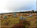
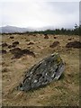
Take the track up Glen Fincastle from the B8019 (the road past Clunie Dam) and walk up into Allean Forest. Surprisingly, the OS map tracks turned out to be relatively accurate this time, which is a bit of a first...
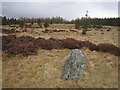
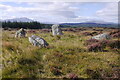
It was a bit misty today, as you will see from the photographs, and I could only make the stones out when I got within around 30m. Pity, as the views are supposed to be pretty spectacular from here. I'll have to wander back on a good day!
One of this site's alternate names is Na Clachan Aoraidh, which means 'the stones of worship'. The site is just to the west of Edintian (another alternate name for the site), a local farm, whose now anglicised name in reality is Aodann an t-Sithein, 'Face of the Fairy Hill', according to Seton ordon's "Highways and Byways in the Central Highlands".
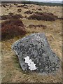
Note: A recent excavation report on this site which was damaged by fire a couple of years ago. Cobbles. Arranged around a pre-existing (sacred?) tree throw. Lots of quartz. Fascinating!
You may be viewing yesterday's version of this page. To see the most up to date information please register for a free account.
")
")
")
")
Do not use the above information on other web sites or publications without permission of the contributor.
Nearby Images from Geograph Britain and Ireland:
©2007(licence)
©2013(licence)
©2021(licence)
©2013(licence)
©2013(licence)
The above images may not be of the site on this page, they are loaded from Geograph.
Please Submit an Image of this site or go out and take one for us!
Click here to see more info for this site
Nearby sites
Key: Red: member's photo, Blue: 3rd party photo, Yellow: other image, Green: no photo - please go there and take one, Grey: site destroyed
Download sites to:
KML (Google Earth)
GPX (GPS waypoints)
CSV (Garmin/Navman)
CSV (Excel)
To unlock full downloads you need to sign up as a Contributory Member. Otherwise downloads are limited to 50 sites.
Turn off the page maps and other distractions
Nearby sites listing. In the following links * = Image available
3.5km ENE 76° Fincastle Farm* Standing Stones (NN87376274)
4.0km NW 324° Whooping Cough Stone (Struan) Natural Stone / Erratic / Other Natural Feature (NN816653)
4.3km NNW 334° Clach na h-Iobairt* Standing Stone (Menhir) (NN82146590)
4.5km NW 316° Struan Pictish Stone* Class I Pictish Symbol Stone (NN80896534)
4.9km NE 47° Clach na h' Iobairt.* Standing Stone (Menhir) (NN87626526)
5.0km ENE 78° Blair Atholl E* Stone Circle (NN88876295)
5.5km ENE 67° Strathgroy Standing Stone (Menhir) (NN8964)
6.8km WNW 285° Kinaldy Standing Stone (Menhir) (NN774639)
7.0km ENE 79° Claverhouse's Stone* Standing Stone (Menhir) (NN90826319)
8.2km SW 230° Tombreck Standing Stone (Menhir) (NN77445693)
9.3km W 263° Upper Gaskan* Stone Circle (NN74666113)
9.4km ESE 104° Craigiedun* Stone Circle (NN930595)
9.5km SE 142° Pitcastle Standing Stones (NN895543)
9.6km ESE 107° Faskally Cottages* Stone Circle (NN930589)
9.6km SE 142° Findynate Farm* Standing Stones (NN89645430)
10.0km SSE 150° Tobairandonaich* Rock Art (NN88665320)
10.3km SSE 153° Derculich Passage Grave (NN884527)
10.4km S 174° Glassie Standing Stone* Standing Stone (Menhir) (NN84715160)
10.5km SE 135° Clach Na Buidseach Rock Art (NN91085435)
10.6km SE 124° Clachan An Diridh* Stone Circle (NN92515574)
10.6km ESE 102° Dane's Stone* Standing Stone (Menhir) (NN9425559414)
10.8km ESE 106° Cnoc Dubh Stone Circle (NN94245871)
10.9km ESE 109° Tobar Argan* Holy Well or Sacred Spring (NN941582)
11.0km ESE 102° Balnakeilly* Standing Stone (Menhir) (NN94655944)
11.5km SSE 162° Tom-an-Droighne Standing Stone (Menhir) (NN87165094)
View more nearby sites and additional images


 We would like to know more about this location. Please feel free to add a brief description and any relevant information in your own language.
 Wir möchten mehr über diese Stätte erfahren. Bitte zögern Sie nicht, eine kurze Beschreibung und relevante Informationen in Deutsch hinzuzufügen.
 Nous aimerions en savoir encore un peu sur les lieux. S'il vous plaît n'hesitez pas à ajouter une courte description et tous les renseignements pertinents dans votre propre langue.
 Quisieramos informarnos un poco más de las lugares. No dude en añadir una breve descripción y otros datos relevantes en su propio idioma.