


<< Our Photo Pages >> Rigg Promontory Fort - Promontory Fort / Cliff Castle in Scotland in Isle of Skye
Submitted by hamilton on Monday, 23 October 2017 Page Views: 2097
Iron Age and Later PrehistorySite Name: Rigg Promontory FortCountry: Scotland
NOTE: This site is 9.3 km away from the location you searched for.
County: Isle of Skye Type: Promontory Fort / Cliff Castle
Nearest Town: Portree Nearest Village: Staffin
Map Ref: NG52375790
Latitude: 57.543203N Longitude: 6.139878W
Condition:
| 5 | Perfect |
| 4 | Almost Perfect |
| 3 | Reasonable but with some damage |
| 2 | Ruined but still recognisable as an ancient site |
| 1 | Pretty much destroyed, possibly visible as crop marks |
| 0 | No data. |
| -1 | Completely destroyed |
| 5 | Superb |
| 4 | Good |
| 3 | Ordinary |
| 2 | Not Good |
| 1 | Awful |
| 0 | No data. |
| 5 | Can be driven to, probably with disabled access |
| 4 | Short walk on a footpath |
| 3 | Requiring a bit more of a walk |
| 2 | A long walk |
| 1 | In the middle of nowhere, a nightmare to find |
| 0 | No data. |
| 5 | co-ordinates taken by GPS or official recorded co-ordinates |
| 4 | co-ordinates scaled from a detailed map |
| 3 | co-ordinates scaled from a bad map |
| 2 | co-ordinates of the nearest village |
| 1 | co-ordinates of the nearest town |
| 0 | no data |
Internal Links:
External Links:
")
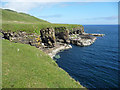
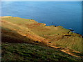
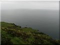
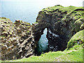
The scant remains of Rigg Promontory Fort stand on a small, triangular coastal promontory, over 100 metres below the car-park area at NC521581, and guarded by 15 metre high cliffs on two sides. Access is not for the faint-hearted: the approach to Rigg Fort is down a very steep slope covered by grass and short bracken. Stout boots are a necessity, as are experience in such terrain and good fitness (you have to climb back up about 120 metres to get back to the car-park).
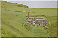
The fort now consists solely of a stout wall, some three metres wide and about half a metre in height, stretching between cliffs to north and south, which would once have barred access to the level area beyond. All that remains is the foundation level, with well preserved outer and inner courses. The entrance is indicated by a gap between the southwest end of the wall and the adjacent deep gulley.
Rigg is in some respects similar to Dun Grugaig at Glasnakille where, again, a small peninsula is protected by a stout wall (in this case reaching some four metres tall in one place).
For more information see Canmore ID 74714.
You may be viewing yesterday's version of this page. To see the most up to date information please register for a free account.
")
")
")
")
Do not use the above information on other web sites or publications without permission of the contributor.
Nearby Images from Geograph Britain and Ireland:
©2010(licence)
©2012(licence)
©2012(licence)
©2012(licence)
©2010(licence)
The above images may not be of the site on this page, they are loaded from Geograph.
Please Submit an Image of this site or go out and take one for us!
Click here to see more info for this site
Nearby sites
Key: Red: member's photo, Blue: 3rd party photo, Yellow: other image, Green: no photo - please go there and take one, Grey: site destroyed
Download sites to:
KML (Google Earth)
GPX (GPS waypoints)
CSV (Garmin/Navman)
CSV (Excel)
To unlock full downloads you need to sign up as a Contributory Member. Otherwise downloads are limited to 50 sites.
Turn off the page maps and other distractions
Nearby sites listing. In the following links * = Image available
1.2km NNW 331° Upper Tote* Cairn (NG51865898)
3.2km NW 308° Dun Taivson Stone Fort or Dun (NG56)
4.5km SSW 207° Old Man of Storr* Rock Outcrop (NG5003853990)
5.2km NNW 339° Dun Connavern* Stone Fort or Dun (NG50856284)
6.5km NNW 348° Dun Dearg* Stone Fort or Dun (NG51376430)
6.7km NNW 339° Dun Raisaburgh* Broch or Nuraghe (NG50326427)
6.8km NNW 343° Raisaburgh Cairn* Cairn (NG508645)
7.5km NNW 342° Dun Grianan* Broch or Nuraghe (NG505652)
9.4km NNW 335° Dun Smail* Stone Fort or Dun (NG489667)
10.1km NNW 340° Cadha Riach* Chambered Tomb (NG49556757)
10.9km NNW 337° Carn Ban (Skye)* Cairn (NG487682)
11.2km NNW 340° An Corran* Ancient Mine, Quarry or other Industry (NG49106860)
11.2km WSW 243° Dun Eyre* Stone Fort or Dun (NG420535)
11.8km WSW 250° Dun Adhamh* Stone Fort or Dun (NG410546)
12.0km SSW 209° Dun Borve (Skye)* Broch or Nuraghe (NG45914772)
12.1km SW 230° Kensalyre Stone* Standing Stone (Menhir) (NG426507)
12.1km NW 325° Dun Beag (Brogaig)* Hillfort (NG46076827)
12.2km WSW 240° Eyre Alignment* Stone Row / Alignment (NG4143252510)
12.2km SW 230° Kensaleyre S Cairn* Cairn (NG42605059)
12.2km SW 230° Kensaleyre N Cairn* Cairn (NG42555064)
12.2km SSW 212° Borve Stone Row* Stone Row / Alignment (NG452480)
12.3km SW 234° Carn Liath (Kensaleyre)* Chambered Cairn (NG420513)
12.3km NW 314° Cleat Hillfort Artificial Mound (NG440670)
12.8km WSW 238° Dun Cruinn* Stone Fort or Dun (NG411518)
12.8km WSW 238° Standing stones below Dun Cruinn* Standing Stones (NG411518)
View more nearby sites and additional images


 We would like to know more about this location. Please feel free to add a brief description and any relevant information in your own language.
 Wir möchten mehr über diese Stätte erfahren. Bitte zögern Sie nicht, eine kurze Beschreibung und relevante Informationen in Deutsch hinzuzufügen.
 Nous aimerions en savoir encore un peu sur les lieux. S'il vous plaît n'hesitez pas à ajouter une courte description et tous les renseignements pertinents dans votre propre langue.
 Quisieramos informarnos un poco más de las lugares. No dude en añadir una breve descripción y otros datos relevantes en su propio idioma.