


<< Our Photo Pages >> Broughwin I - Multiple Stone Rows / Avenue in Scotland in Highlands
Submitted by Anonymous on Monday, 11 November 2002 Page Views: 6527
Neolithic and Bronze AgeSite Name: Broughwin I Alternative Name: Broughwin NE; Broughwhin LochCountry: Scotland County: Highlands Type: Multiple Stone Rows / Avenue
Nearest Town: Thurso Nearest Village: Whaligoe / Bruan
Map Ref: ND3130741222 Landranger Map Number: 11
Latitude: 58.354077N Longitude: 3.175448W
Condition:
| 5 | Perfect |
| 4 | Almost Perfect |
| 3 | Reasonable but with some damage |
| 2 | Ruined but still recognisable as an ancient site |
| 1 | Pretty much destroyed, possibly visible as crop marks |
| 0 | No data. |
| -1 | Completely destroyed |
| 5 | Superb |
| 4 | Good |
| 3 | Ordinary |
| 2 | Not Good |
| 1 | Awful |
| 0 | No data. |
| 5 | Can be driven to, probably with disabled access |
| 4 | Short walk on a footpath |
| 3 | Requiring a bit more of a walk |
| 2 | A long walk |
| 1 | In the middle of nowhere, a nightmare to find |
| 0 | No data. |
| 5 | co-ordinates taken by GPS or official recorded co-ordinates |
| 4 | co-ordinates scaled from a detailed map |
| 3 | co-ordinates scaled from a bad map |
| 2 | co-ordinates of the nearest village |
| 1 | co-ordinates of the nearest town |
| 0 | no data |
Internal Links:
External Links:
I have visited· I would like to visit
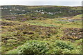
SandyG visited on 9th Aug 2014 - their rating: Cond: 2 Amb: 4 Access: 4 Car parking is available at ND 31885 40851. Follow the signposting to the Cairn O’Get. The stone row is situated about 100m to the north of the Cairn O’Get across uneven open moorland.
tom_bullock have visited here
")
Update October 2019: This site is featured on the Stone Rows of Great Britain website - see their entry for Broughwhin I, where SandyG carried out recent surveys. His entry includes a description of the row, a plan of the row with its associated cairn, photographs of the alignment and the individual stones, plus access information.
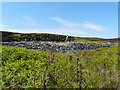
The row is also recorded as Canmore ID 9019, which tells us: "The remains of a cairn, much dilapidated and overgrown with heather, lie on the top of a low ridge, some 80 yds east of the north end of Broughwhin Loch … Very little is now visible of the stone rows that lay on the slope below the cairn to the SSW".
The Highland HER also includes a record for this site - see MHG2185 (Cairn & Stone Rows, Broughwhin Loch).
You may be viewing yesterday's version of this page. To see the most up to date information please register for a free account.
")
")
")
Do not use the above information on other web sites or publications without permission of the contributor.
Nearby Images from Geograph Britain and Ireland:

©2009(licence)

©2021(licence)
©2022(licence)
©2009(licence)

©2022(licence)
The above images may not be of the site on this page, they are loaded from Geograph.
Please Submit an Image of this site or go out and take one for us!
Click here to see more info for this site
Nearby sites
Key: Red: member's photo, Blue: 3rd party photo, Yellow: other image, Green: no photo - please go there and take one, Grey: site destroyed
Download sites to:
KML (Google Earth)
GPX (GPS waypoints)
CSV (Garmin/Navman)
CSV (Excel)
To unlock full downloads you need to sign up as a Contributory Member. Otherwise downloads are limited to 50 sites.
![]()
Turn off the page maps and other distractions
Nearby sites listing. In the following links * = Image available
102m NE 46° Garrywhin Multiple Stone Rows* Multiple Stone Rows / Avenue (ND3138241291)
104m SSE 166° Cairn o'Get* Chambered Cairn (ND31334112)
164m NNW 340° Garrywhin Fort* Hillfort (ND3125341377)
203m E 97° Watenan Farm* Multiple Stone Rows / Avenue (ND3150941193)
236m SSW 202° Broughwin IV* Multiple Stone Rows / Avenue (ND3121541004)
262m S 191° Broughwin II* Multiple Stone Rows / Avenue (ND3125440965)
415m E 99° Watenan South Broch* Broch or Nuraghe (ND3171641147)
446m SSW 213° Cairn east of Cairn Hanach* Cairn (ND31064085)
454m ESE 107° Loch Watenan* Multiple Stone Rows / Avenue (ND31744108)
469m SSW 205° Broughwin III* Stone Row / Alignment (ND3110040800)
481m SW 218° Cairn Hanach* Chambered Cairn (ND31004085)
548m ENE 64° Watenan North Broch Broch or Nuraghe (ND3180441456)
630m SSW 206° Groat’s Loch, South* Stone Row / Alignment (ND3102340658)
789m S 183° Clash-an-dam* Stone Row / Alignment (ND3125640434)
809m E 81° Marquel Stone Row / Alignment (ND32114134)
915m NNE 26° Watenan East* Stone Row / Alignment (ND31724204)
956m W 269° Warehouse Hill Broch or Nuraghe (ND3034841227)
957m N 360° Watenan West* Stone Row / Alignment (ND31324218)
1.1km NW 319° Warehouse South* Chambered Cairn (ND3057342081)
1.2km ENE 75° Ulbster School Broch or Nuraghe (ND3243141497)
1.2km NW 317° Warehouse West* Cairn (ND3050742107)
1.3km NW 317° Warehouse Standing Stone* Standing Stone (Menhir) (ND3046242147)
1.3km NW 324° Warehouse North* Chambered Cairn (ND3056742276)
1.4km NW 318° Yarrows Fort* Hillfort (ND3041342265)
1.5km ENE 70° Heatherquoy Broch or Nuraghe (ND3271341714)
View more nearby sites and additional images


 We would like to know more about this location. Please feel free to add a brief description and any relevant information in your own language.
 Wir möchten mehr über diese Stätte erfahren. Bitte zögern Sie nicht, eine kurze Beschreibung und relevante Informationen in Deutsch hinzuzufügen.
 Nous aimerions en savoir encore un peu sur les lieux. S'il vous plaît n'hesitez pas à ajouter une courte description et tous les renseignements pertinents dans votre propre langue.
 Quisieramos informarnos un poco más de las lugares. No dude en añadir una breve descripción y otros datos relevantes en su propio idioma.