Featured: Hare and Tabor T Shirts for discerning antiquarians

Hare and Tabor T Shirts for discerning antiquarians

Random Image


Cefn Llanerchi

See Your Book Here

See Your Book Here

Who's Online

There are currently, 230 guests and 6 members online.

You are a guest. To join in, please register for free by clicking here

Sponsors

<< Our Photo Pages >> St. Nicholas Church - Ancient Village or Settlement in Scotland in Orkney

Submitted by howar on Monday, 23 August 2004  Page Views: 5339

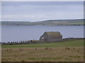
Multi-periodSite Name: St. Nicholas Church
Country: Scotland
NOTE: This site is 0.8 km away from the location you searched for.

County: Orkney Type: Ancient Village or Settlement
Nearest Town: Kirkwall  Nearest Village: St. Mary's
Map Ref: HY510006
Latitude: 58.889934N  Longitude: 2.851889W
Condition:
5Perfect
4Almost Perfect
3Reasonable but with some damage
2Ruined but still recognisable as an ancient site
1Pretty much destroyed, possibly visible as crop marks
0No data.
-1Completely destroyed
2 Ambience:
5Superb
4Good
3Ordinary
2Not Good
1Awful
0No data.
3 Access:
5Can be driven to, probably with disabled access
4Short walk on a footpath
3Requiring a bit more of a walk
2A long walk
1In the middle of nowhere, a nightmare to find
0No data.
3 Accuracy:
5co-ordinates taken by GPS or official recorded co-ordinates
4co-ordinates scaled from a detailed map
3co-ordinates scaled from a bad map
2co-ordinates of the nearest village
1co-ordinates of the nearest town
0no data
3

Internal Links:
External Links:

St. Nicholas Church
St. Nicholas Church submitted by howar : site seen from Wester Sand (Vote or comment on this photo)
Settlement in Orkney.
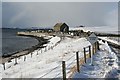
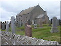
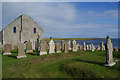
RCAHMS NMRS No. HY50SW 15. There has been a church at the present site since 1570, it has been rebuilt once.

It is believed that there was a previous church on the mound where part of the graveyard lies as various drystane walls have shown up and a Celtic cross-slab has been found.
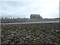
This mound extends well beyond the churchyard and was originally a settlement. A ring of stones protrudes at the summit HY51010065 in the field to the north of the church. Last century 40 trailer-loads of stones, including many red ones, were removed from HY51010065 and dumped on the shore at HY50880075. Amongst these was a redstone block with 6 cupmarks which has since disappeared.
Despite not knowing this at the time of my visit it was fairly obvious that the place had a pre-ecclesiastical significance, with the later church site (if perhaps not the original) being placed beside the mound rather than on it and continuing outwith the existing walls. In Orkney several religious buildings were built on or by brochs.
Not far away lies an archaeologically recent bridge with a no dumping sign. Beneath it on the other side, and at right angles to it, is a smaller and more primitive bridge HY508009. This bridge is on one end of the newer bridge and at the other is a very tall drystane wall. Taken together these two items lead me to believe the mound behind them could well be settlement related.

You may be viewing yesterday's version of this page. To see the most up to date information please register for a free account.


St. Nicholas Church
St. Nicholas Church submitted by howar : Some of main pottery scatter, inset sherd with 50mm wide tape. (Vote or comment on this photo)

St. Nicholas Church
St. Nicholas Church submitted by howar : Lowenkratzen - late rock art Christianised or Christian folk-medicine. (3 comments - Vote or comment on this photo)

St. Nicholas Church
St. Nicholas Church submitted by howar : Small early structure as cropmark. (Vote or comment on this photo)

St. Nicholas Church
St. Nicholas Church submitted by howar : broch ?foundation (Vote or comment on this photo)

Do not use the above information on other web sites or publications without permission of the contributor.

Nearby Images from Geograph Britain and Ireland:
HY5100 : St Nicholas Kirk, Holm, Orkney by Karl Cooper
by Karl Cooper
©2006(licence)
HY5100 : Holm: St. Nicholas kirk from the beach by Chris Downer
by Chris Downer
©2011(licence)
HY5100 : Holm: St. Nicholas kirk by Chris Downer
by Chris Downer
©2011(licence)
HY5100 : St Nicholas Kirk and graveyard by Bill Boaden
by Bill Boaden
©2013(licence)
HY5100 : Holm: St. Nicholas kirk from the north by Chris Downer
by Chris Downer
©2011(licence)

The above images may not be of the site on this page, they are loaded from Geograph.
Please Submit an Image of this site or go out and take one for us!


Click here to see more info for this site

Nearby sites

Click here to view sites on an interactive OS map

Key: Red: member's photo, Blue: 3rd party photo, Yellow: other image, Green: no photo - please go there and take one, Grey: site destroyed

Download sites to:
KML (Google Earth)
GPX (GPS waypoints)
CSV (Garmin/Navman)
CSV (Excel)

To unlock full downloads you need to sign up as a Contributory Member. Otherwise downloads are limited to 50 sites.


Turn off the page maps and other distractions

Nearby sites listing. In the following links * = Image available
 499m SE 126° Castle Howe (Orkney)* Ancient Village or Settlement (HY514003)
 1.8km NW 304° Tower of Clett* Artificial Mound (HY4949701654)
 2.2km SE 131° Roseness* Chambered Cairn (ND52629917)
 2.2km SE 144° Rose Ness* Chambered Cairn (ND5228698813)
 2.3km WNW 302° Mass Howe* Misc. Earthwork (HY49090181)
 2.4km NW 315° Crearhowe* Artificial Mound (HY49300235)
 2.6km W 267° Lamb Holm* Ancient Village or Settlement (HY484005)
 2.8km SW 229° Northfield Broch* Broch or Nuraghe (ND489988)
 3.3km ENE 59° The Cairn* Artificial Mound (HY53840223)
 3.3km NW 307° Hall of Gorn* Round Barrow(s) (HY484026)
 3.4km NW 305° Laughton's Knowe* Round Barrow(s) (HY48260258)
 3.6km ENE 59° Stembister farm stone* Standing Stone (Menhir) (HY54130239)
 3.9km NNE 26° Campston (Toab)* Broch or Nuraghe (HY528041)
 4.1km W 281° St Mary's Broch* Broch or Nuraghe (HY470014)
 4.4km NE 35° St. Peter's Kirk* Ancient Village or Settlement (HY536042)
 4.5km NE 36° Campston Cairn* Cairn (HY537042)
 4.5km SSW 203° St Lawrence's Church* Broch or Nuraghe (ND4917896425)
 4.6km NW 305° Holm Chambered Tomb* Chambered Tomb (HY473033)
 4.6km NE 41° Comely* Cairn (HY54040403)
 4.6km NE 54° Peerie Howe* Ancient Village or Settlement (HY54750324)
 4.6km NE 54° Dingieshowe* Ancient Village or Settlement (HY54760330)
 4.7km NE 34° St. Peter's Bay Mound* Broch or Nuraghe (HY537045)
 5.1km WNW 302° Gutterpool* Misc. Earthwork (HY467034)
 5.2km NE 56° Sandaiken* Ancient Village or Settlement (HY55380346)
 5.3km N 356° Burn of Langskaill* Ancient Village or Settlement (HY507059)
View more nearby sites and additional images

<< Caer Bach

Bookan Stones >>

Please add your thoughts on this site

Neolithic Britain And Ireland

Neolithic Britain And Ireland

Sponsors

Auto-Translation (Google)

Translate from English into:

"St. Nicholas Church" | Login/Create an Account | 6 News and Comments
  
Go back to top of page    Comments are owned by the poster. We aren't responsible for their content.
Re: St. Nicholas Church by howar on Tuesday, 08 January 2008
(User Info | Send a Message)
For the first time since the deep ploughing the ground in the field behind the kirkyard has been exposed, harrowed with stubble. Walking inside the modern wall and looking over there is still plenty of material copiously 'littering' it, awaiting an archaeologist with the competence needed to make sure identifications. This is a narrow window of opportunity going abegging. Coming around from the top of the church end and down towards roadside by the eastern half I could see amongst the gravestones a thin slab only just showing, different stone than them though, and only a yard or so away a gravestone embedded in what looks to be a very short piece of old wall. This is inside the graveyard piece where the circular edge mentioned previously appeared to end, so probably continuance. Though the circular feature of record was in the field this is surely roundhouse which has been squared off by the present church with a line of edgeset slabs.
[ Reply to This ]

Re: St. Nicholas Church by howar on Saturday, 03 February 2007
(User Info | Send a Message)
At the moment behind the kirkyard the stubble field is profusely littered with mostly small pieces of pot and stone - this is no fieldwalkable-scatter, you'd keep an army of volunteers rooted to a snail's pace. Unfortunately no trace of bone found yesterday (last year I collected a few of the small fragments left by the second ploughing and put them in a supermarket bag, along with other samples such as the slag the hand-y stone and several humungous potsherds, and took them to Orkney Museum). Much of the remaining material looks fired or burnt. One chunk I picked up was well over an inch in each direction and had a black band down one side about a centimetre thick.
[ Reply to This ]

Re: St. Nicholas Church by nicoladidsbury on Thursday, 27 April 2006
(User Info | Send a Message)
Incredible find Wideford, and a really interesting article. Thanks for posting. I bet it was great finding and wondering about all those interesting items
[ Reply to This ]

Re: St. Nicholas Church by howar on Thursday, 27 April 2006
(User Info | Send a Message)
When I paid a second visit yesterday the farmer had been over the field again.
Perhaps because of reduced contrast with the ploughsoil I had difficulty seeing the pottery fragments or the larger building stones (the foot cube is gone completely, but that anything is left after 40 cartloads of stones removed is something). Unable to find the bone joint or the object fragments from the bottom of the slope by the pond. Found some bone fragments near the summit of the hillock and down the opposite side of the hillock to the fieldgate.
But the plough has uncovered a significant area of very different potsherds. These mostly come from two patches (or a single larger one), each of several metres, in the region of HY50980065 on the slope towards the fieldgate. The sherds have very thick bases but with walls in the region of half-a-centimetre, very thin looking. To the naked eye the composition of these would appear to be only rather fine clay, making the pot stiff but not very strong (unfired ?).
Having taken shelter in the kirkyard I found a cropmark indicative of a small structure that as far as I can tell is to do with the wall reported at HY51050064. The entrance (??incurving) seems to be at the eastern side. A low wall runs about a metre from the west side of the church, composed of orthostats except at the top end where a stone appears to exhibit leonkratten /lowenkratten (I think that is the phrase for the linear gouges).
[ Reply to This ]
    Re: St. Nicholas Church by howar on Saturday, 29 April 2006
    (User Info | Send a Message)
    The curving section of cemetery bank west of the church appears to indicate original broch-type dimensions on the order of ~30m (the Orkney Antiquarian Society chairman observed excavations in the Holm Churchyard and had no doubts as to it being one - "The Orcadian" of March 29th 1923). The arc runs from HY51000062 to HY50990063. If there was a circular feature a slight chord was taken out of the eastern end by the path, in contrast to the eastern end where a larger section is missing.
    [ Reply to This ]

Re: St. Nicholas Church by Anonymous on Tuesday, 25 April 2006
Going along the road to the South Isles and at the narrow triangular junction of A and B roads take that indicated as leading to Toab rather than St.Mary's, and continue on past the war memorial junction (alternatively coming up from the South Isles as you pass the last Churchill Barrier take the RH junction along the B9052 and hang a right at the war memorial) and past the Little Howes continue past that for Deerness. Just past Vigga take a right again at the junction. St.Nicholas Church is at the bottom of the hill by the beach, and appears on the 1:25,000 (Explorer 461) as "cemetery". The early stuff is the summit of the small hillock directly back of the kirkyard.
The church site dates back to at least 1570, but the presence of a -mohr placename in the area indicates a probable dedication from a much earlier time, that of the so-called "Evening Star" missionaries. The present building is distinctly to one side of the summit and drystone walls have been discovered in other areas. Outside of the kirkyard wall, at HY51010065 a circle of stones was once thought to be a broch, but no longer (?? a lleyn precinct). However one of the drystone walls discovered was dicovered nearby, at HY51010066, and produced roughly 40 trailer-loads of stone, including a red sandstone having six cupmarks. Unfortunately the latter disappeared after the material was removed to the shore at HY50880075, lost to the waves one assumes.
Alas when I paid a visit on Friday it was to discover that the possible structure outwith the present compound was gone - many stones present but not even an arc remaining. I may only have missed it by a matter of days, as the field has recently been subjected to deep and vigorous ploughing - I saw several stones of the order of a metre across and close to the border a whopper one foot cube. As this part of the field is composed of a steep hillock over a large submerged section it must have been considered too marginal before this time. I expect the farmer will shortly remove all material that he considers extraneous - bye bye site ? There is some burnt material, which looked to decrease in size but increase in quantity the further downslope one looked. Browsing the edge I could also see are fragments of pottery, of which there could be some larger sherds. From my time at The Howe I recognised what I took to be prehistoric pottery of slightly rough composition, wall in the region of 1cm, mid earth brown with a much darker outer surface. Some of the fragments were burnt/red. And there were stone tools of various types and sizes, some of quite dense material. I picked up a piece of sub-rectangular (very unlinear) stone just because it looked interesting, never expecting it to be anything but geological, only to find that it fitted my hand perfectly (fractionally bigger in length though) and a curve along one edge accomodated my Mount of Venus (or ball of the thumb) most wondrously and the thumb crossing the surface nicely. What I was amazed to discover near the border was an entirely unexpected piece of slag maybe for inches across and a couple high. So perhaps another ironworking site like Snusgar or the Knowe of Verron (also perhaps to be associated with a Mohr monastery in the vicinity) ? Went back towards the fieldgate and skirted the (hopefully) temporary pond around the bottom of the hillslope, looking for the possibility of burnt mound material without luck (actually I suspect a good place for one of these is by the burn uphill on the road a little). What I did find where two broken pieces of red stone speckled brightly through out. They were probably part of the same object, an end piece about three inches long and a middle section an inch or so longer. This latter resembled a "french stick" in cross-section in being a very well-rounded semi-circle.
From the point of view of material remains the ploughed area is fabulous. Even if all someone did was remove the objects in the ploughsoil without regard to co-ordinates there would be enough to keep a team busy for years in my opin

Read the rest of this post...
[ Reply to This ]

Your Name: Anonymous [ Register Now ]
Subject:


Add your comment or contribution to this page. Spam or offensive posts are deleted immediately, don't even bother

<<< What is five plus one as a number? (Please type the answer to this question in the little box on the left)
You can also embed videos and other things. For Youtube please copy and paste the 'embed code'.
For Google Street View please include Street View in the text.
Create a web link like this: <a href="https://www.megalithic.co.uk">This is a link</a>  

Allowed HTML is:
<p> <b> <i> <a> <img> <em> <br> <strong> <blockquote> <tt> <li> <ol> <ul> <object> <param> <embed> <iframe>

We would like to know more about this location. Please feel free to add a brief description and any relevant information in your own language.
Wir möchten mehr über diese Stätte erfahren. Bitte zögern Sie nicht, eine kurze Beschreibung und relevante Informationen in Deutsch hinzuzufügen.
Nous aimerions en savoir encore un peu sur les lieux. S'il vous plaît n'hesitez pas à ajouter une courte description et tous les renseignements pertinents dans votre propre langue.
Quisieramos informarnos un poco más de las lugares. No dude en añadir una breve descripción y otros datos relevantes en su propio idioma.