

<< Our Photo Pages >> Setter Noost - Ancient Village or Settlement in Scotland in Orkney
Submitted by howar on Friday, 05 March 2021 Page Views: 386
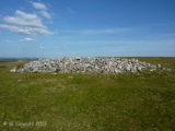
Iron Age and Later PrehistorySite Name: Setter Noost Alternative Name: Setter NoustCountry: Scotland
NOTE: This site is 0.6 km away from the location you searched for.
County: Orkney Type: Ancient Village or Settlement
Nearest Town: Kirkwall Nearest Village: Balfour Village
Map Ref: HY47301621
Latitude: 59.029662N Longitude: 2.919802W
Condition:
| 5 | Perfect |
| 4 | Almost Perfect |
| 3 | Reasonable but with some damage |
| 2 | Ruined but still recognisable as an ancient site |
| 1 | Pretty much destroyed, possibly visible as crop marks |
| 0 | No data. |
| -1 | Completely destroyed |
| 5 | Superb |
| 4 | Good |
| 3 | Ordinary |
| 2 | Not Good |
| 1 | Awful |
| 0 | No data. |
| 5 | Can be driven to, probably with disabled access |
| 4 | Short walk on a footpath |
| 3 | Requiring a bit more of a walk |
| 2 | A long walk |
| 1 | In the middle of nowhere, a nightmare to find |
| 0 | No data. |
| 5 | co-ordinates taken by GPS or official recorded co-ordinates |
| 4 | co-ordinates scaled from a detailed map |
| 3 | co-ordinates scaled from a bad map |
| 2 | co-ordinates of the nearest village |
| 1 | co-ordinates of the nearest town |
| 0 | no data |
Internal Links:
External Links:
")
In 1972 in the low shore twenty metres west of a ruined lime kiln (possibly Lady Well re-used) in a seventeen metre exposure the O.S. saw several orthostats and bits of drystane wall as well as a midden 1.3 metres thick. At the west end of this an obvious external wall-face was in 1985 thought to be from some kind of round house, and quite a large one at that. In 1998 the Setter Noust site is described as walling indicative of an early structure and tumbled stone, with pot and bone and burnt stone in the extended midden.
There was an erdhus in the vicinity too. Balfour Castle is based on an earlier grand house called Cliffdale, and sometime prior to 1796, close to the site of several failed lead mines, a souterrain came to light. RCAHMS record no. HY41NE 12 (location unknown) was sunk about a yard deep and had a roof of large slabs set on four foot high pillars (aka masonry piers). It comprised twin hexagonal cells, each about 8' across, and a rectangular one the same. A finger-ring of gold came from this passage.
You may be viewing yesterday's version of this page. To see the most up to date information please register for a free account.
")
")
")
")
")
")
")
")
")
")
Do not use the above information on other web sites or publications without permission of the contributor.
Click here to see more info for this site
Nearby sites
Key: Red: member's photo, Blue: 3rd party photo, Yellow: other image, Green: no photo - please go there and take one, Grey: site destroyed
Download sites to:
KML (Google Earth)
GPX (GPS waypoints)
CSV (Garmin/Navman)
CSV (Excel)
To unlock full downloads you need to sign up as a Contributory Member. Otherwise downloads are limited to 50 sites.
Turn off the page maps and other distractions
Nearby sites listing. In the following links * = Image available
540m W 273° Twi Ness* Cairn (HY46761625)
1.4km ESE 107° Helliar Holm Broch or Nuraghe (HY48591579)
2.6km SSE 156° Head of Work* Chambered Cairn (HY48341382)
2.9km E 86° Broch of Steiro* Broch or Nuraghe (HY50191635)
3.9km E 92° Howe Hill (Howe Farm)* Ancient Village or Settlement (HY51171599)
4.4km NE 48° Odin Stone* Standing Stone (Menhir) (HY506191)
5.0km SW 229° Lower Saverock* Not Known (by us) (HY43511300)
5.0km ESE 104° Hacksness (Shapinsay) Cairn (HY52181491)
5.1km SW 227° Saverock (2)* Ancient Village or Settlement (HY43481280)
5.1km E 82° Mor Stein* Standing Stone (Menhir) (HY52401685)
5.4km WSW 243° Ramberry Cairn Chambered Cairn (HY42401383)
5.5km SSW 214° Grain Earth House* Souterrain (Fogou, Earth House) (HY442117)
5.6km SSW 203° Kirkwall Sculptured Stone (HY450111)
5.8km SSW 203° Kirkwall Sculptured Stone (HY44941087)
5.9km SSW 204° Tankerness House Museum* Museum (HY44851086)
5.9km SSW 204° The Orkney Museum* Museum (HY448108)
6.0km SSW 212° Pickaquoy* Ancient Village or Settlement (HY44071116)
6.0km NW 308° Knowe of Dishero* Broch or Nuraghe (HY42561998)
6.2km S 177° Berstane Broch* Broch or Nuraghe (HY475100)
6.3km E 87° Castle Bloody* Souterrain (Fogou, Earth House) (HY53581644)
6.3km NE 54° Unyatuak* Artificial Mound (HY52451983)
6.3km NW 315° Holm of Rendall* Cairn (HY4283220735)
6.5km WSW 239° Quanterness* Chambered Cairn (HY417129)
6.6km NNW 338° Gairsay Cairn (HY44942237)
6.7km S 183° Tower Hill (Orkney)* Round Barrow(s) (HY469095)
View more nearby sites and additional images


 We would like to know more about this location. Please feel free to add a brief description and any relevant information in your own language.
 Wir möchten mehr über diese Stätte erfahren. Bitte zögern Sie nicht, eine kurze Beschreibung und relevante Informationen in Deutsch hinzuzufügen.
 Nous aimerions en savoir encore un peu sur les lieux. S'il vous plaît n'hesitez pas à ajouter une courte description et tous les renseignements pertinents dans votre propre langue.
 Quisieramos informarnos un poco más de las lugares. No dude en añadir una breve descripción y otros datos relevantes en su propio idioma.