


<< Other Photo Pages >> Kompleks Sejarah Pengkalan Kempas - Standing Stones in Malaysia
Submitted by XIII on Friday, 02 December 2016 Page Views: 2779
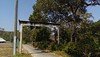
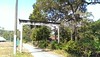
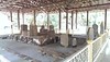
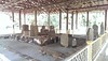
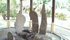
Neolithic and Bronze AgeSite Name: Kompleks Sejarah Pengkalan Kempas Alternative Name: Sword, Rudder and Spoon megalithsCountry: Malaysia
NOTE: This site is 285.623 km away from the location you searched for.
Type: Standing Stones
Nearest Town: Linggi
Latitude: 2.450458N Longitude: 102.015233E
Condition:
| 5 | Perfect |
| 4 | Almost Perfect |
| 3 | Reasonable but with some damage |
| 2 | Ruined but still recognisable as an ancient site |
| 1 | Pretty much destroyed, possibly visible as crop marks |
| 0 | No data. |
| -1 | Completely destroyed |
| 5 | Superb |
| 4 | Good |
| 3 | Ordinary |
| 2 | Not Good |
| 1 | Awful |
| 0 | No data. |
| 5 | Can be driven to, probably with disabled access |
| 4 | Short walk on a footpath |
| 3 | Requiring a bit more of a walk |
| 2 | A long walk |
| 1 | In the middle of nowhere, a nightmare to find |
| 0 | No data. |
| 5 | co-ordinates taken by GPS or official recorded co-ordinates |
| 4 | co-ordinates scaled from a detailed map |
| 3 | co-ordinates scaled from a bad map |
| 2 | co-ordinates of the nearest village |
| 1 | co-ordinates of the nearest town |
| 0 | no data |
Internal Links:
External Links:
")
The most well known are nicknamed the rudder, spoon and sword respectively due to their distinctive shapes. The megaliths are known as 'Living Stones' and some of the town residents swear that they grow taller by one or two inches every year.
source:
malaysia traveller
streetview:
You may be viewing yesterday's version of this page. To see the most up to date information please register for a free account.
")
")
Do not use the above information on other web sites or publications without permission of the contributor.
Nearby Images from Flickr
The above images may not be of the site on this page, but were taken nearby. They are loaded from Flickr so please click on them for image credits.
Click here to see more info for this site
Nearby sites
Click here to view sites on an interactive map of the areaKey: Red: member's photo, Blue: 3rd party photo, Yellow: other image, Green: no photo - please go there and take one, Grey: site destroyed
Download sites to:
KML (Google Earth)
GPX (GPS waypoints)
CSV (Garmin/Navman)
CSV (Excel)
To unlock full downloads you need to sign up as a Contributory Member. Otherwise downloads are limited to 50 sites.
Turn off the page maps and other distractions
Nearby sites listing. In the following links * = Image available
18.1km E 83° Melaka* Standing Stones
26.0km ESE 113° Makam Datuk Paduka Seri Maharaja Lela Standing Stones
28.3km E 91° Masjid Kampung Kemuning Standing Stones
34.5km NNE 21° Tapak Megalitik Stone Row / Alignment
65.1km NNW 327° Laman Megalit* Standing Stones
84.7km NNW 335° Muzium Negara* Museum
258.7km NNW 338° Gua Tambun Rock Art
286.7km N 355° Gua Cha Cave or Rock Shelter
292.7km NNE 14° Bewah Cave Cave or Rock Shelter
311.8km NNW 338° Lenggong Archaeological Museum* Museum
365.0km NNW 332° Cherok Tokun Carving
406.4km NNW 334° Lembah Bujang Ancient Village or Settlement
502.0km S 180° Ngalau Ulu Tjangko Cave* Cave or Rock Shelter
687.7km SSE 163° Bilik Kubur Batu Burial Chamber or Dolmen
699.3km NNW 341° Nakhon Si Thammarat National Museum* Museum
700.5km NNW 341° Wat Phra Mahathat* Ancient Temple
703.3km NNW 341° Nakhon Si Thammarat City Wall* Ancient Village or Settlement
725.4km NNW 332° Tham Lang Rongrien Cave or Rock Shelter
726.9km SSE 167° Segayun megalithic site Ancient Village or Settlement
732.5km S 169° Skendal Standing Stones
733.2km S 169° Arca Macan Complex Sculptured Stone
733.2km S 169° Rie Tebing Cave Cave or Rock Shelter
734.3km S 169° Tinggihari Complex Sculptured Stone
735.7km NNW 327° Thalang Museum Museum
742.0km SSE 168° Tegurwangi Sculptured Stone
View more nearby sites and additional images


 We would like to know more about this location. Please feel free to add a brief description and any relevant information in your own language.
 Wir möchten mehr über diese Stätte erfahren. Bitte zögern Sie nicht, eine kurze Beschreibung und relevante Informationen in Deutsch hinzuzufügen.
 Nous aimerions en savoir encore un peu sur les lieux. S'il vous plaît n'hesitez pas à ajouter une courte description et tous les renseignements pertinents dans votre propre langue.
 Quisieramos informarnos un poco más de las lugares. No dude en añadir una breve descripción y otros datos relevantes en su propio idioma.