


<< Our Photo Pages >> Republican Museum of Kyzyl - Museum in Russia
Submitted by AlexAssa on Monday, 21 January 2019 Page Views: 871
MuseumsSite Name: Republican Museum of KyzylCountry: Russia
NOTE: This site is 1.911 km away from the location you searched for.
Type: Museum
Nearest Town: Kyzyl
Latitude: 51.719070N Longitude: 94.429403E
Condition:
| 5 | Perfect |
| 4 | Almost Perfect |
| 3 | Reasonable but with some damage |
| 2 | Ruined but still recognisable as an ancient site |
| 1 | Pretty much destroyed, possibly visible as crop marks |
| 0 | No data. |
| -1 | Completely destroyed |
| 5 | Superb |
| 4 | Good |
| 3 | Ordinary |
| 2 | Not Good |
| 1 | Awful |
| 0 | No data. |
| 5 | Can be driven to, probably with disabled access |
| 4 | Short walk on a footpath |
| 3 | Requiring a bit more of a walk |
| 2 | A long walk |
| 1 | In the middle of nowhere, a nightmare to find |
| 0 | No data. |
| 5 | co-ordinates taken by GPS or official recorded co-ordinates |
| 4 | co-ordinates scaled from a detailed map |
| 3 | co-ordinates scaled from a bad map |
| 2 | co-ordinates of the nearest village |
| 1 | co-ordinates of the nearest town |
| 0 | no data |
Internal Links:
External Links:
")
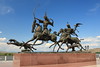
Stellarium of the Republican Museum of Kyzyl
It houses a large collection of various stone steles, idols and other ancient finds.
Megalithica.ru
You may be viewing yesterday's version of this page. To see the most up to date information please register for a free account.
")
")
")
Do not use the above information on other web sites or publications without permission of the contributor.
Nearby Images from Flickr
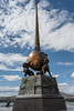


The above images may not be of the site on this page, but were taken nearby. They are loaded from Flickr so please click on them for image credits.
Click here to see more info for this site
Nearby sites
Click here to view sites on an interactive map of the areaKey: Red: member's photo, Blue: 3rd party photo, Yellow: other image, Green: no photo - please go there and take one, Grey: site destroyed
Download sites to:
KML (Google Earth)
GPX (GPS waypoints)
CSV (Garmin/Navman)
CSV (Excel)
To unlock full downloads you need to sign up as a Contributory Member. Otherwise downloads are limited to 50 sites.
Turn off the page maps and other distractions
Nearby sites listing. In the following links * = Image available
64.7km NW 311° Arzhan Scythian royal necropolis* Barrow Cemetery
138.5km W 266° Ancient sanctuary Chaa-Holl* Rock Cut Tomb
298.7km SSE 156° Lake Oygon Round Barrows Round Barrow(s)
299.8km NW 319° Museum Kyzlasov L.R.* Museum
344.7km NW 316° Great Salbyk Kurgan* Pyramid / Mastaba
423.4km NW 317° Tuim Cromlech* Stone Circle
447.7km NW 314° Paleolithic settlement Small Syya* Ancient Village or Settlement
450.1km ESE 118° Moron Deer Stones* Standing Stones
454.9km NW 319° Complex Sunduki* Natural Stone / Erratic / Other Natural Feature
468.7km WSW 245° Tarhatinsky megalithic site* Standing Stones
487.3km NNW 348° Settlement Afontova Mountain* Ancient Village or Settlement
487.6km NNW 349° Krasnoyarsk Regional Museum of Local Lore* Museum
521.3km WSW 238° Mt. Shiveet altar stone with petroglyphs* Rock Art
524.1km WSW 239° Shiveet Mountain Petroglyphs* Rock Art
539.9km SE 136° Tariat Deer Stone* Standing Stones
547.3km WSW 258° Chuya Deer Stone* Standing Stone (Menhir)
549.2km SW 234° Lake Hoton Round Barrow Round Barrow(s)
551.5km WSW 258° Kalbak-Tash* Rock Art
552.3km SW 232° Lake Hoton Standing Grave Stones* Standing Stones
552.8km SW 234° Lake Hoton Petroglyphs* Rock Art
563.5km WSW 258° Inya Deer Stones* Standing Stone (Menhir)
579.5km W 275° Oldest settlement Ulalinka* Ancient Village or Settlement
583.1km W 276° Anokhin Museum* Museum
584.8km W 277° Mayma VI Barrow Cemetery
602.2km W 264° Tuekta kurgan* Artificial Mound
View more nearby sites and additional images


 We would like to know more about this location. Please feel free to add a brief description and any relevant information in your own language.
 Wir möchten mehr über diese Stätte erfahren. Bitte zögern Sie nicht, eine kurze Beschreibung und relevante Informationen in Deutsch hinzuzufügen.
 Nous aimerions en savoir encore un peu sur les lieux. S'il vous plaît n'hesitez pas à ajouter une courte description et tous les renseignements pertinents dans votre propre langue.
 Quisieramos informarnos un poco más de las lugares. No dude en añadir una breve descripción y otros datos relevantes en su propio idioma.