 with our Megalithic Portal iPhone app")


<< Text Pages >> Bielstein - Natural Stone / Erratic / Other Natural Feature in Germany in Lower Saxony, Bremen
Submitted by KaiHofmann on Tuesday, 11 February 2014 Page Views: 1254
Natural PlacesSite Name: BielsteinCountry: Germany
NOTE: This site is 11.661 km away from the location you searched for.
Land: Lower Saxony, Bremen Type: Natural Stone / Erratic / Other Natural Feature
Nearest Town: Göttingen Nearest Village: Gleichen
Latitude: 51.467470N Longitude: 9.992450E
Condition:
| 5 | Perfect |
| 4 | Almost Perfect |
| 3 | Reasonable but with some damage |
| 2 | Ruined but still recognisable as an ancient site |
| 1 | Pretty much destroyed, possibly visible as crop marks |
| 0 | No data. |
| -1 | Completely destroyed |
| 5 | Superb |
| 4 | Good |
| 3 | Ordinary |
| 2 | Not Good |
| 1 | Awful |
| 0 | No data. |
| 5 | Can be driven to, probably with disabled access |
| 4 | Short walk on a footpath |
| 3 | Requiring a bit more of a walk |
| 2 | A long walk |
| 1 | In the middle of nowhere, a nightmare to find |
| 0 | No data. |
| 5 | co-ordinates taken by GPS or official recorded co-ordinates |
| 4 | co-ordinates scaled from a detailed map |
| 3 | co-ordinates scaled from a bad map |
| 2 | co-ordinates of the nearest village |
| 1 | co-ordinates of the nearest town |
| 0 | no data |
Internal Links:
External Links:
Natural Stone / Erratic / Other Natural Feature in Lower Saxony, Bremen
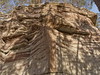
Large rock with two engraved early disk-crosses, cup-marks and furrows.
You may be viewing yesterday's version of this page. To see the most up to date information please register for a free account.
Do not use the above information on other web sites or publications without permission of the contributor.
Nearby Images from Flickr

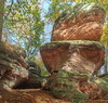
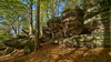
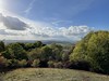
The above images may not be of the site on this page, but were taken nearby. They are loaded from Flickr so please click on them for image credits.
Click here to see more info for this site
Nearby sites
Click here to view sites on an interactive map of the areaKey: Red: member's photo, Blue: 3rd party photo, Yellow: other image, Green: no photo - please go there and take one, Grey: site destroyed
Download sites to:
KML (Google Earth)
GPX (GPS waypoints)
CSV (Garmin/Navman)
CSV (Excel)
To unlock full downloads you need to sign up as a Contributory Member. Otherwise downloads are limited to 50 sites.
Turn off the page maps and other distractions
Nearby sites listing. In the following links * = Image available
1.0km ENE 57° Bärental Kreuz Early Christian Sculptured Stone
16.0km W 275° Altarstein Dransfeld Rock Art
19.8km W 259° Schalenstein Wiershausen* Rock Art
22.8km NNW 345° Großenrode (2)* Chambered Tomb
24.4km W 266° Steinkreis Gimte* Stone Circle
24.5km S 172° Brandwall Hohestein Hillfort
25.6km NW 309° Schäferstein Verliehausen Stone Circle
25.8km ENE 58° Rhumequelle* Holy Well or Sacred Spring
27.6km NNW 341° Opferteich Moringen Holy Well or Sacred Spring
28.7km S 187° Todstein Natural Stone / Erratic / Other Natural Feature
29.3km SE 137° Drei Kreuze Küllstedt Ancient Cross
30.9km NE 39° Jettenhöhle* Cave or Rock Shelter
31.2km NNE 24° Lichtensteinhöhle* Cave or Rock Shelter
32.4km NE 55° Steinkirche* Cave or Rock Shelter
33.5km NE 38° Teufelsloch Osterode* Holy Well or Sacred Spring
34.0km ENE 57° Einhornhoehle* Cave or Rock Shelter
34.9km SSW 204° Hollensteine Natural Stone / Erratic / Other Natural Feature
37.8km SW 234° Summstein Grüne Mitte Modern Stone Circle etc
39.0km WSW 244° Hessisches Landesmuseum Kassel* Museum
39.4km ENE 70° Steina Monolith Natural Stone / Erratic / Other Natural Feature
40.7km WSW 243° Summstein Schönfeld Modern Stone Circle etc
40.9km NE 44° Hanskühnenburg-Klippe* Rock Outcrop
41.4km NNE 11° Infogebäude am römisch-germansichen Schlachtfeld Museum
41.8km W 260° Calden (1)* Passage Grave
42.3km SSE 160° Hüneburg Schnellmannshausen Causewayed Enclosure
View more nearby sites and additional images


 We would like to know more about this location. Please feel free to add a brief description and any relevant information in your own language.
 Wir möchten mehr über diese Stätte erfahren. Bitte zögern Sie nicht, eine kurze Beschreibung und relevante Informationen in Deutsch hinzuzufügen.
 Nous aimerions en savoir encore un peu sur les lieux. S'il vous plaît n'hesitez pas à ajouter une courte description et tous les renseignements pertinents dans votre propre langue.
 Quisieramos informarnos un poco más de las lugares. No dude en añadir una breve descripción y otros datos relevantes en su propio idioma.