 with our Megalithic Portal iPhone app")


<< Text Pages >> Vellberg Natur und Heimatmuseum - Museum in Germany in Baden-Wuerttemberg
Submitted by AlexHunger on Tuesday, 13 September 2005 Page Views: 2049
MuseumsSite Name: Vellberg Natur und HeimatmuseumCountry: Germany
NOTE: This site is 3.338 km away from the location you searched for.
Land: Baden-Wuerttemberg Type: Museum
Nearest Town: Stuttgart Nearest Village: Vellberg
Latitude: 49.086130N Longitude: 9.881610E
Condition:
| 5 | Perfect |
| 4 | Almost Perfect |
| 3 | Reasonable but with some damage |
| 2 | Ruined but still recognisable as an ancient site |
| 1 | Pretty much destroyed, possibly visible as crop marks |
| 0 | No data. |
| -1 | Completely destroyed |
| 5 | Superb |
| 4 | Good |
| 3 | Ordinary |
| 2 | Not Good |
| 1 | Awful |
| 0 | No data. |
| 5 | Can be driven to, probably with disabled access |
| 4 | Short walk on a footpath |
| 3 | Requiring a bit more of a walk |
| 2 | A long walk |
| 1 | In the middle of nowhere, a nightmare to find |
| 0 | No data. |
| 5 | co-ordinates taken by GPS or official recorded co-ordinates |
| 4 | co-ordinates scaled from a detailed map |
| 3 | co-ordinates scaled from a bad map |
| 2 | co-ordinates of the nearest village |
| 1 | co-ordinates of the nearest town |
| 0 | no data |
Be the first person to rate this site - see the 'Contribute!' box in the right hand menu.
Internal Links:
External Links:
Museum in Baden-Württemberg
IMPORTANT NOTE: Site believed to be near this position. Artifacts from Bussen
Address: Eschennaür Strasse 7, 74541
Phone: 0049 7907 8770
Opening Hours: Sundays and holidays 14:30 to 16:30 or by appointment
You may be viewing yesterday's version of this page. To see the most up to date information please register for a free account.
Do not use the above information on other web sites or publications without permission of the contributor.
Nearby Images from Flickr
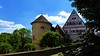

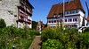
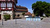
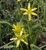
The above images may not be of the site on this page, but were taken nearby. They are loaded from Flickr so please click on them for image credits.
Click here to see more info for this site
Nearby sites
Click here to view sites on an interactive map of the areaKey: Red: member's photo, Blue: 3rd party photo, Yellow: other image, Green: no photo - please go there and take one, Grey: site destroyed
Download sites to:
KML (Google Earth)
GPX (GPS waypoints)
CSV (Garmin/Navman)
CSV (Excel)
To unlock full downloads you need to sign up as a Contributory Member. Otherwise downloads are limited to 50 sites.
Turn off the page maps and other distractions
Nearby sites listing. In the following links * = Image available
495m NNW 342° Stöckenburg Ancient Village or Settlement
11.0km WNW 285° Summstein Schwäbisch Hall Modern Stone Circle etc
13.4km NE 34° Triensbach Grabhügelgruppe Barrow Cemetery
18.2km N 358° Langenburg Keltische Viereckschanze Ancient Village or Settlement
23.2km NW 313° Mangoldsall Modern Menhir* Modern Stone Circle etc
28.0km S 169° Grubenholz Grabhügelgruppe Barrow Cemetery
28.1km NW 320° Niedernhall Grabhügelfeld Barrow Cemetery
32.7km S 169° Höhle Haus am Rosenstein Cave or Rock Shelter
32.7km S 169° Grosse Scheuer* Cave or Rock Shelter
33.2km S 170° Finsteres Loch* Cave or Rock Shelter
33.2km S 171° Rosenstein Wallanlage C Hillfort
33.4km NNW 339° Hoehle St.Wendel zum Stein Cave or Rock Shelter
33.4km S 172° Kleine Scheuer* Cave or Rock Shelter
33.4km S 172° Dreieingangshöhle Rosenstein Cave or Rock Shelter
34.3km W 272° Summstein Lichtenstern I Modern Stone Circle etc
34.3km W 272° Summstein Lichtenstern II Modern Stone Circle etc
35.6km N 10° Niederstetten Keltische Viereckschanze Ancient Village or Settlement
38.4km NNE 32° Engelsburg Keltenwall* Hillfort
40.3km ESE 123° Frühkeltische Grabhügelgruppe Bückleshau Barrow Cemetery
40.9km NW 325° Bürgerwald Grabhügelgruppe Barrow Cemetery
41.4km SSE 147° Grosskuchen Eisenbrunnen Holy Well or Sacred Spring
42.2km SE 125° Ipf Höhensiedlung* Hillfort
42.4km NNE 24° Burgstall Oppidum* Hillfort
42.6km NW 322° Steinig Wald Grabhügel Artificial Mound
43.1km WSW 255° Hexenbuckele Artificial Mound
View more nearby sites and additional images


 We would like to know more about this location. Please feel free to add a brief description and any relevant information in your own language.
 Wir möchten mehr über diese Stätte erfahren. Bitte zögern Sie nicht, eine kurze Beschreibung und relevante Informationen in Deutsch hinzuzufügen.
 Nous aimerions en savoir encore un peu sur les lieux. S'il vous plaît n'hesitez pas à ajouter une courte description et tous les renseignements pertinents dans votre propre langue.
 Quisieramos informarnos un poco más de las lugares. No dude en añadir una breve descripción y otros datos relevantes en su propio idioma.