


<< Our Photo Pages >> Friedland Huegelgrab (2) - Round Barrow(s) in Germany in Schleswig-Holstein, Hamburg
Submitted by krautrock on Sunday, 25 January 2009 Page Views: 2656
Neolithic and Bronze AgeSite Name: Friedland Huegelgrab (2)Country: Germany
NOTE: This site is 2.433 km away from the location you searched for.
Land: Schleswig-Holstein, Hamburg Type: Round Barrow(s)
Nearest Town: Eckernfoerde Nearest Village: Friedland
Latitude: 54.462100N Longitude: 9.779850E
Condition:
| 5 | Perfect |
| 4 | Almost Perfect |
| 3 | Reasonable but with some damage |
| 2 | Ruined but still recognisable as an ancient site |
| 1 | Pretty much destroyed, possibly visible as crop marks |
| 0 | No data. |
| -1 | Completely destroyed |
| 5 | Superb |
| 4 | Good |
| 3 | Ordinary |
| 2 | Not Good |
| 1 | Awful |
| 0 | No data. |
| 5 | Can be driven to, probably with disabled access |
| 4 | Short walk on a footpath |
| 3 | Requiring a bit more of a walk |
| 2 | A long walk |
| 1 | In the middle of nowhere, a nightmare to find |
| 0 | No data. |
| 5 | co-ordinates taken by GPS or official recorded co-ordinates |
| 4 | co-ordinates scaled from a detailed map |
| 3 | co-ordinates scaled from a bad map |
| 2 | co-ordinates of the nearest village |
| 1 | co-ordinates of the nearest town |
| 0 | no data |
Internal Links:
External Links:
 (PID:45015)")
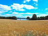
This Round Barrow is situated like a massive pancake in that wavy scenery. You can find some stones on the tomb. I think most of them are collected from the field by the farmer.
You may be viewing yesterday's version of this page. To see the most up to date information please register for a free account.
 (PID:45014)")
 (PID:54176)")
Do not use the above information on other web sites or publications without permission of the contributor.
Nearby Images from Flickr

The above images may not be of the site on this page, but were taken nearby. They are loaded from Flickr so please click on them for image credits.
Click here to see more info for this site
Nearby sites
Click here to view sites on an interactive map of the areaKey: Red: member's photo, Blue: 3rd party photo, Yellow: other image, Green: no photo - please go there and take one, Grey: site destroyed
Download sites to:
KML (Google Earth)
GPX (GPS waypoints)
CSV (Garmin/Navman)
CSV (Excel)
To unlock full downloads you need to sign up as a Contributory Member. Otherwise downloads are limited to 50 sites.
Turn off the page maps and other distractions
Nearby sites listing. In the following links * = Image available
227m WSW 259° Friedland Huegelgrab (3)* Round Barrow(s)
618m WNW 286° Friedland Huegelgrab (4)* Round Barrow(s)
748m WNW 292° Windeby Langbett* Long Barrow
1.3km NW 324° Kochendorf Langbett Long Barrow
1.4km W 268° Osterby Dolmen Burial Chamber or Dolmen
1.6km NNW 330° Kochendorf Huegelgrab* Round Barrow(s)
3.9km SSE 152° Goosefeld Steingrab 3* Burial Chamber or Dolmen
4.1km SSE 154° Goosefeld Steingrab 1* Burial Chamber or Dolmen
4.8km SE 145° Goosefeld Steingrab 2* Burial Chamber or Dolmen
5.1km N 10° Gammelby-Eichthal Steingrab* Burial Chamber or Dolmen
5.4km SSE 155° Goosefeld Langbett* Long Barrow
5.4km N 357° Kosel Ganggrab Passage Grave
5.5km SSE 148° Goosefeld Dolmen* Burial Chamber or Dolmen
5.6km SSE 156° Lehmsieck Huegelgrab (1)* Round Barrow(s)
5.6km SSE 158° Lehmsieck Huegelgrab (2)* Round Barrow(s)
5.9km SSE 160° Gross Wittensee Dolmen* Burial Chamber or Dolmen
6.2km ENE 62° Hemmelmark Steingrab (12)* Burial Chamber or Dolmen
6.4km ENE 65° Hemmelmark Steingrab (13)* Burial Chamber or Dolmen
6.8km ENE 57° Hemmelmark Steingrab (9)* Long Barrow
6.8km ENE 58° Hemmelmark Steingrab (14)* Chambered Tomb
6.9km ENE 57° Hemmelmark Steingrab (10)* Long Barrow
6.9km ENE 58° Hemmelmark Steingrab (9b)* Burial Chamber or Dolmen
6.9km ENE 58° Hemmelmark Steingrab (11)* Long Barrow
7.1km ESE 113° Altenhof Huegelgrab* Round Barrow(s)
7.2km ENE 60° Hemmelmark Steingrab (8)* Burial Chamber or Dolmen
View more nearby sites and additional images


 We would like to know more about this location. Please feel free to add a brief description and any relevant information in your own language.
 Wir möchten mehr über diese Stätte erfahren. Bitte zögern Sie nicht, eine kurze Beschreibung und relevante Informationen in Deutsch hinzuzufügen.
 Nous aimerions en savoir encore un peu sur les lieux. S'il vous plaît n'hesitez pas à ajouter une courte description et tous les renseignements pertinents dans votre propre langue.
 Quisieramos informarnos un poco más de las lugares. No dude en añadir una breve descripción y otros datos relevantes en su propio idioma.