


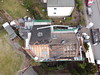
<< Our Photo Pages >> Bokholt-Hanredder Huegelgrab - Round Barrow(s) in Germany in Schleswig-Holstein, Hamburg
Submitted by Nype on Tuesday, 05 April 2011 Page Views: 2677
Neolithic and Bronze AgeSite Name: Bokholt-Hanredder HuegelgrabCountry: Germany
NOTE: This site is 3.323 km away from the location you searched for.
Land: Schleswig-Holstein, Hamburg Type: Round Barrow(s)
Nearest Town: Elmshorn Nearest Village: Bokholt-Hanredder
Latitude: 53.769261N Longitude: 9.717836E
Condition:
| 5 | Perfect |
| 4 | Almost Perfect |
| 3 | Reasonable but with some damage |
| 2 | Ruined but still recognisable as an ancient site |
| 1 | Pretty much destroyed, possibly visible as crop marks |
| 0 | No data. |
| -1 | Completely destroyed |
| 5 | Superb |
| 4 | Good |
| 3 | Ordinary |
| 2 | Not Good |
| 1 | Awful |
| 0 | No data. |
| 5 | Can be driven to, probably with disabled access |
| 4 | Short walk on a footpath |
| 3 | Requiring a bit more of a walk |
| 2 | A long walk |
| 1 | In the middle of nowhere, a nightmare to find |
| 0 | No data. |
| 5 | co-ordinates taken by GPS or official recorded co-ordinates |
| 4 | co-ordinates scaled from a detailed map |
| 3 | co-ordinates scaled from a bad map |
| 2 | co-ordinates of the nearest village |
| 1 | co-ordinates of the nearest town |
| 0 | no data |
Be the first person to rate this site - see the 'Contribute!' box in the right hand menu.
Internal Links:
External Links:
")
Barrow is hard to see; although it is not really a small one, it is quite flat. In good condition. Maybe there are one or two more smaller ones around, hard to say. Some local maps show it, that's the reason I found it at all.
Situated in a nice little forest near the Krückau-Wanderweg. A broad path leads to a huge meadow and it passes by this tumulus. Quiet area although it is easy to access. Why not have a short visit on a fine summer day?
You may be viewing yesterday's version of this page. To see the most up to date information please register for a free account.
Do not use the above information on other web sites or publications without permission of the contributor.
Nearby Images from Flickr

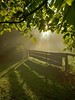

The above images may not be of the site on this page, but were taken nearby. They are loaded from Flickr so please click on them for image credits.
Click here to see more info for this site
Nearby sites
Click here to view sites on an interactive map of the areaKey: Red: member's photo, Blue: 3rd party photo, Yellow: other image, Green: no photo - please go there and take one, Grey: site destroyed
Download sites to:
KML (Google Earth)
GPX (GPS waypoints)
CSV (Garmin/Navman)
CSV (Excel)
To unlock full downloads you need to sign up as a Contributory Member. Otherwise downloads are limited to 50 sites.
Turn off the page maps and other distractions
Nearby sites listing. In the following links * = Image available
867m SSW 203° Koelln-Reisiek Huegelgrab* Round Barrow(s)
1.0km SSW 213° Koelln Huegelgrab* Round Barrow(s)
4.7km ESE 108° Bevern Huegelgraeber* Barrow Cemetery
7.1km SSE 147° Summstein Sonnenweg Modern Stone Circle etc
7.3km ENE 69° Grelck'sche Tannen Huegelgraeber* Barrow Cemetery
7.4km ENE 78° Heede Huegelgrab* Round Barrow(s)
8.3km ENE 62° Heeder Tannen Huegelgraeberfeld* Barrow Cemetery
8.3km E 87° Hemdingen Langbett* Long Barrow
9.0km ENE 70° Langeln Hillfort* Hillfort
9.1km E 86° Hemdingen Huegelgraeberfeld* Barrow Cemetery
9.1km NE 40° Warensberg Lutzhorn* Barrow Cemetery
9.6km ENE 67° Langeln Huegelgraeberfeld* Barrow Cemetery
9.7km E 85° Bilsen* Barrow Cemetery
10.3km S 181° Appen Huegelgrab* Round Barrow(s)
10.9km NNE 14° Bokel Grabhuegel* Barrow Cemetery
12.5km NNE 19° Moenkloh Butterberg* Round Barrow(s)
12.9km NNE 30° Heidmoor Huegelgrab* Round Barrow(s)
13.5km ESE 107° Quickborn Grabhuegel* Round Barrow(s)
13.6km NNE 16° Moenkloh Grabhuegelgruppen* Barrow Cemetery
14.4km NNE 22° Mönkloh East* Barrow Cemetery
15.2km NNE 29° Weddelbrook Grabhuegel Duevelskoppel* Barrow Cemetery
15.4km NNE 29° Weddelbrook Huegelgrab* Round Barrow(s)
15.4km S 180° Holm Huegelgrab* Round Barrow(s)
16.2km E 87° Henstedt-Ulzburg Theebarg* Hillfort
16.3km ENE 58° Wuesten Grabhuegel* Round Barrow(s)
View more nearby sites and additional images


 We would like to know more about this location. Please feel free to add a brief description and any relevant information in your own language.
 Wir möchten mehr über diese Stätte erfahren. Bitte zögern Sie nicht, eine kurze Beschreibung und relevante Informationen in Deutsch hinzuzufügen.
 Nous aimerions en savoir encore un peu sur les lieux. S'il vous plaît n'hesitez pas à ajouter une courte description et tous les renseignements pertinents dans votre propre langue.
 Quisieramos informarnos un poco más de las lugares. No dude en añadir una breve descripción y otros datos relevantes en su propio idioma.