


<< Our Photo Pages >> Orruttu Nuraghe - Broch or Nuraghe in Italy in Sardinia (Sardegna)
Submitted by francescomanconi on Sunday, 29 September 2019 Page Views: 495
Neolithic and Bronze AgeSite Name: Orruttu NuragheCountry: Italy
NOTE: This site is 4.955 km away from the location you searched for.
Region: Sardinia (Sardegna) Type: Broch or Nuraghe
Nearest Town: Lanusei Nearest Village: Osini
Latitude: 39.820745N Longitude: 9.472677E
Condition:
| 5 | Perfect |
| 4 | Almost Perfect |
| 3 | Reasonable but with some damage |
| 2 | Ruined but still recognisable as an ancient site |
| 1 | Pretty much destroyed, possibly visible as crop marks |
| 0 | No data. |
| -1 | Completely destroyed |
| 5 | Superb |
| 4 | Good |
| 3 | Ordinary |
| 2 | Not Good |
| 1 | Awful |
| 0 | No data. |
| 5 | Can be driven to, probably with disabled access |
| 4 | Short walk on a footpath |
| 3 | Requiring a bit more of a walk |
| 2 | A long walk |
| 1 | In the middle of nowhere, a nightmare to find |
| 0 | No data. |
| 5 | co-ordinates taken by GPS or official recorded co-ordinates |
| 4 | co-ordinates scaled from a detailed map |
| 3 | co-ordinates scaled from a bad map |
| 2 | co-ordinates of the nearest village |
| 1 | co-ordinates of the nearest town |
| 0 | no data |
Internal Links:
External Links:
")
In the wonderful valley of "Taccu de Osini", the first nuraghe you meet, along the road to the left (to the right is the road to nuraghe Serbissi). A circular building (Capanna delle riunioni) near the only tower. The entrance is only 1 metre and a half above ground; that means it needs an excavation of 2 meters more.
You may be viewing yesterday's version of this page. To see the most up to date information please register for a free account.
Do not use the above information on other web sites or publications without permission of the contributor.
Nearby Images from Flickr
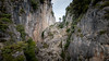
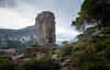
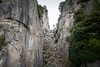
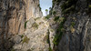
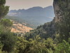
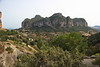
The above images may not be of the site on this page, but were taken nearby. They are loaded from Flickr so please click on them for image credits.
Click here to see more info for this site
Nearby sites
Click here to view sites on an interactive map of the areaKey: Red: member's photo, Blue: 3rd party photo, Yellow: other image, Green: no photo - please go there and take one, Grey: site destroyed
Download sites to:
KML (Google Earth)
GPX (GPS waypoints)
CSV (Garmin/Navman)
CSV (Excel)
To unlock full downloads you need to sign up as a Contributory Member. Otherwise downloads are limited to 50 sites.
Turn off the page maps and other distractions
Nearby sites listing. In the following links * = Image available
664m SW 228° Sanu Nuraghe (Osini)* Broch or Nuraghe
2.9km NNW 340° Serbissi Nuraghe* Broch or Nuraghe
2.9km NNW 340° Serbissi Grotta* Cave or Rock Shelter
5.9km SW 233° Is Coccoronis Nuraghe Broch or Nuraghe
7.3km NE 36° Gennaccili Nuraghe e Villaggio Nuragico* Broch or Nuraghe
7.4km NNE 33° Seleni II Tomba di Giganti* Chambered Tomb
7.5km NNE 32° Seleni I Tomba di Giganti* Chambered Tomb
7.9km W 266° Useligis Nuraghe Broch or Nuraghe
8.0km WSW 237° Arcu Addai Nuraghe Broch or Nuraghe
8.8km WNW 295° Anulu Insediamento Nuragico Ancient Village or Settlement
8.9km WNW 294° Anulu Nuraghe Broch or Nuraghe
11.1km ENE 75° Monte Nuraxi Nuraghe Broch or Nuraghe
11.7km ESE 101° Musciu Nuraghe* Broch or Nuraghe
12.3km ENE 60° Sa Campana Nuraghe Broch or Nuraghe
12.5km ENE 71° Is Arceddas Domus de Janas Rock Cut Tomb
12.7km E 101° Trunconi Nuraghe* Broch or Nuraghe
13.1km NW 309° Mercussei Fonte Nuragica* Holy Well or Sacred Spring
13.3km WNW 303° Pauli Nuraghe (Seui)* Broch or Nuraghe
14.0km NW 305° Ardasai Nuraghe* Broch or Nuraghe
14.0km NE 49° Sceri Insediamento Nuragico* Ancient Village or Settlement
14.0km NE 49° Sceri Domus de Janas* Rock Cut Tomb
14.1km NW 304° Ardasai Tomba di Giganti* Chambered Tomb
14.1km NE 49° Sceri Nuraghe* Broch or Nuraghe
14.3km ENE 65° Elurci Nuraghe* Broch or Nuraghe
14.6km E 86° Mattale Nuraghe Broch or Nuraghe
View more nearby sites and additional images


 We would like to know more about this location. Please feel free to add a brief description and any relevant information in your own language.
 Wir möchten mehr über diese Stätte erfahren. Bitte zögern Sie nicht, eine kurze Beschreibung und relevante Informationen in Deutsch hinzuzufügen.
 Nous aimerions en savoir encore un peu sur les lieux. S'il vous plaît n'hesitez pas à ajouter une courte description et tous les renseignements pertinents dans votre propre langue.
 Quisieramos informarnos un poco más de las lugares. No dude en añadir una breve descripción y otros datos relevantes en su propio idioma.