

<< Our Photo Pages >> Vaale Rugenbarg Steinkiste - Cist in Germany in Schleswig-Holstein, Hamburg
Submitted by holger_rix on Saturday, 28 July 2007 Page Views: 3196
Neolithic and Bronze AgeSite Name: Vaale Rugenbarg SteinkisteCountry: Germany
NOTE: This site is 3.018 km away from the location you searched for.
Land: Schleswig-Holstein, Hamburg Type: Cist
Nearest Town: Itzehoe Nearest Village: Vaale
Latitude: 54.010436N Longitude: 9.390836E
Condition:
| 5 | Perfect |
| 4 | Almost Perfect |
| 3 | Reasonable but with some damage |
| 2 | Ruined but still recognisable as an ancient site |
| 1 | Pretty much destroyed, possibly visible as crop marks |
| 0 | No data. |
| -1 | Completely destroyed |
| 5 | Superb |
| 4 | Good |
| 3 | Ordinary |
| 2 | Not Good |
| 1 | Awful |
| 0 | No data. |
| 5 | Can be driven to, probably with disabled access |
| 4 | Short walk on a footpath |
| 3 | Requiring a bit more of a walk |
| 2 | A long walk |
| 1 | In the middle of nowhere, a nightmare to find |
| 0 | No data. |
| 5 | co-ordinates taken by GPS or official recorded co-ordinates |
| 4 | co-ordinates scaled from a detailed map |
| 3 | co-ordinates scaled from a bad map |
| 2 | co-ordinates of the nearest village |
| 1 | co-ordinates of the nearest town |
| 0 | no data |
Internal Links:
External Links:
I have visited· I would like to visit
DrewParsons would like to visit
")
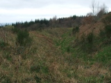
The 'Rugenbarg' is an area near Vaale. Vaale is very close to Wacken, famous for its yearly Heavy Metal Events.
You have to start from the 'Landweg', at 54° 0'25.02"N 9°23'25.01"E (54.006950N, 9.390281E). There is a path through the forest, little signs show the way. You come accross some round barrows (Grabhuegel) and at the end of the forest you will find an open barrow.
This barrow was opened in 1884. Inside was the 'Steinkiste', a stone tomb.
You may be viewing yesterday's version of this page. To see the most up to date information please register for a free account.
")
")
")
")
")
")
")
")
")
")
")
Do not use the above information on other web sites or publications without permission of the contributor.
Click here to see more info for this site
Nearby sites
Click here to view sites on an interactive map of the areaKey: Red: member's photo, Blue: 3rd party photo, Yellow: other image, Green: no photo - please go there and take one, Grey: site destroyed
Download sites to:
KML (Google Earth)
GPX (GPS waypoints)
CSV (Garmin/Navman)
CSV (Excel)
To unlock full downloads you need to sign up as a Contributory Member. Otherwise downloads are limited to 50 sites.
Turn off the page maps and other distractions
Nearby sites listing. In the following links * = Image available
88m SE 145° Vaale Rugenbarg Grabhuegel 3* Round Barrow(s)
248m S 173° Vaale Rugenbarg Grabhuegel 2* Round Barrow(s)
799m E 99° Vaale Rugenbarg Grabhuegel 4* Round Barrow(s)
826m E 87° Vaale Rugenbarg Grabhuegel 1* Round Barrow(s)
5.8km ENE 67° Krinkberg Grabhuegel* Round Barrow(s)
6.9km ESE 117° Eversdorf Huegelgrab 2* Round Barrow(s)
7.0km ESE 116° Eversdorf Huegelgrab 1* Round Barrow(s)
8.0km N 10° Keller Huegelgrab* Round Barrow(s)
8.2km NNW 341° Oersdorfer Viert Huegelgrab* Round Barrow(s)
8.4km NNW 327° Luetjenbornholt Grabhuegel* Round Barrow(s)
9.9km NNE 16° Thaden Steingrab 2* Burial Chamber or Dolmen
9.9km NNE 16° Thaden Steingrab 1* Passage Grave
9.9km NNE 16° Thaden Steingrab 3 Long Barrow
9.9km NNE 16° Thaden Steingrab 4 Long Barrow
10.5km NW 325° Schafstedt Huegelgrab 3* Round Barrow(s)
10.5km NW 325° Schafstedt Huegelgrab 1* Round Barrow(s)
10.6km NW 326° Schafstedt Huegelgrab 2* Round Barrow(s)
12.0km NE 52° Puls Steingrab* Long Barrow
12.1km SE 137° Itzehoe Germanengrab am Galgenberg* Round Barrow(s)
12.2km SE 137° Itzehoe Steingrab [Warringholz]* Passage Grave
12.2km SE 129° Itzehoe Grabhuegelgruppe 2* Barrow Cemetery
12.3km NNW 346° Gruenental Huegelgrab* Round Barrow(s)
12.3km WSW 258° Buchholz Huegelgrab 1* Round Barrow(s)
12.4km WSW 255° Kuden Huegelgrab 1* Round Barrow(s)
12.6km W 277° Frestedt Huegelgrab 2* Round Barrow(s)
View more nearby sites and additional images


 We would like to know more about this location. Please feel free to add a brief description and any relevant information in your own language.
 Wir möchten mehr über diese Stätte erfahren. Bitte zögern Sie nicht, eine kurze Beschreibung und relevante Informationen in Deutsch hinzuzufügen.
 Nous aimerions en savoir encore un peu sur les lieux. S'il vous plaît n'hesitez pas à ajouter une courte description et tous les renseignements pertinents dans votre propre langue.
 Quisieramos informarnos un poco más de las lugares. No dude en añadir una breve descripción y otros datos relevantes en su propio idioma.