

<< Our Photo Pages >> Hügelgrab bei Dinghorn - Round Barrow(s) in Germany in Lower Saxony, Bremen
Submitted by CharcoalBurner89 on Wednesday, 24 November 2021 Page Views: 379
Neolithic and Bronze AgeSite Name: Hügelgrab bei DinghornCountry: Germany
NOTE: This site is 1.744 km away from the location you searched for.
Land: Lower Saxony, Bremen Type: Round Barrow(s)
Nearest Town: Fredenbeck Nearest Village: Dinghorn
Latitude: 53.507760N Longitude: 9.361630E
Condition:
| 5 | Perfect |
| 4 | Almost Perfect |
| 3 | Reasonable but with some damage |
| 2 | Ruined but still recognisable as an ancient site |
| 1 | Pretty much destroyed, possibly visible as crop marks |
| 0 | No data. |
| -1 | Completely destroyed |
| 5 | Superb |
| 4 | Good |
| 3 | Ordinary |
| 2 | Not Good |
| 1 | Awful |
| 0 | No data. |
| 5 | Can be driven to, probably with disabled access |
| 4 | Short walk on a footpath |
| 3 | Requiring a bit more of a walk |
| 2 | A long walk |
| 1 | In the middle of nowhere, a nightmare to find |
| 0 | No data. |
| 5 | co-ordinates taken by GPS or official recorded co-ordinates |
| 4 | co-ordinates scaled from a detailed map |
| 3 | co-ordinates scaled from a bad map |
| 2 | co-ordinates of the nearest village |
| 1 | co-ordinates of the nearest town |
| 0 | no data |
Internal Links:
External Links:
")
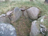
According to the old Prussian map, the tumulus is the last of a once large group of tumuli that may even have existed at the end of the 19th century (see map).
You may be viewing yesterday's version of this page. To see the most up to date information please register for a free account.
")
")
")
Do not use the above information on other web sites or publications without permission of the contributor.
Nearby Images from Flickr


The above images may not be of the site on this page, but were taken nearby. They are loaded from Flickr so please click on them for image credits.
Click here to see more info for this site
Nearby sites
Click here to view sites on an interactive map of the areaKey: Red: member's photo, Blue: 3rd party photo, Yellow: other image, Green: no photo - please go there and take one, Grey: site destroyed
Download sites to:
KML (Google Earth)
GPX (GPS waypoints)
CSV (Garmin/Navman)
CSV (Excel)
To unlock full downloads you need to sign up as a Contributory Member. Otherwise downloads are limited to 50 sites.
Turn off the page maps and other distractions
Nearby sites listing. In the following links * = Image available
3.0km WSW 245° Hügelgräber im Bullenholz* Round Barrow(s)
3.4km SE 124° Hügelgrab bei Wedel (1)* Round Barrow(s)
3.7km SE 126° Hügelgrab bei Wedel (2)* Round Barrow(s)
4.2km SW 227° Schalenstein von Mulsum* Rock Art
4.2km NNW 338° Hügelgrab bei Hagenah (Nr. 1)* Round Barrow(s)
4.3km NNW 337° Hügelgräber bei Hagenah (Nr. 2-3)* Round Barrow(s)
4.3km NNW 343° Hügelgräber bei Hagenah (Nr. 4-6)* Round Barrow(s)
4.4km NNW 346° Hügelgräber bei Hagenah (Nr. 7-9)* Round Barrow(s)
4.5km NNW 348° Hügelgrab bei Hagenah (Nr. 10)* Round Barrow(s)
4.6km NW 324° Hagenah Steinkistengrab* Cist
5.0km E 94° Deinste Steingrab 2* Burial Chamber or Dolmen
5.3km SW 216° Hügelgrab bei Kutenholz* Round Barrow(s)
5.8km W 260° Hügelgräber im Horner Holz (1-7)* Round Barrow(s)
6.1km E 85° Deinste Huenengrab* Passage Grave
6.3km NW 326° Hügelgrab bei der Siedlung Hagenah* Round Barrow(s)
6.9km NNE 20° Grabhügel Schwinger Tannen Round Barrow(s)
7.3km WSW 245° Hügelgrab am Weitenbruchsmoor* Round Barrow(s)
7.4km NNW 345° Heinbockel Megalithgrab* Chambered Tomb
7.6km NNW 329° Hügelgräber bei der Siedlung Heinbockel (1-4)* Round Barrow(s)
7.7km SSW 212° Hügelgrab bei Byhusen (5)* Round Barrow(s)
7.7km E 98° Ohrensen - Die sieben Berge* Barrow Cemetery
7.7km SSW 209° Hügelgrab bei Byhusen (6)* Round Barrow(s)
7.7km NNW 329° Hügelgräber bei der Siedlung Heinbockel (5)* Round Barrow(s)
7.8km E 98° Ohrensen Steingrab* Long Barrow
7.9km NNW 347° Heinbockel Hügelgrab* Round Barrow(s)
View more nearby sites and additional images


 We would like to know more about this location. Please feel free to add a brief description and any relevant information in your own language.
 Wir möchten mehr über diese Stätte erfahren. Bitte zögern Sie nicht, eine kurze Beschreibung und relevante Informationen in Deutsch hinzuzufügen.
 Nous aimerions en savoir encore un peu sur les lieux. S'il vous plaît n'hesitez pas à ajouter une courte description et tous les renseignements pertinents dans votre propre langue.
 Quisieramos informarnos un poco más de las lugares. No dude en añadir una breve descripción y otros datos relevantes en su propio idioma.