


<< Text Pages >> S'Arcu 'e S'Arcedda Nuraghe - Broch or Nuraghe in Italy in Sardinia (Sardegna)
Submitted by SolarMegalith on Saturday, 26 May 2012 Page Views: 1383
Neolithic and Bronze AgeSite Name: S'Arcu 'e S'Arcedda NuragheCountry: Italy
NOTE: This site is 8.151 km away from the location you searched for.
Region: Sardinia (Sardegna) Type: Broch or Nuraghe
Nearest Village: Tasonis
Latitude: 39.322004N Longitude: 9.268599E
Condition:
| 5 | Perfect |
| 4 | Almost Perfect |
| 3 | Reasonable but with some damage |
| 2 | Ruined but still recognisable as an ancient site |
| 1 | Pretty much destroyed, possibly visible as crop marks |
| 0 | No data. |
| -1 | Completely destroyed |
| 5 | Superb |
| 4 | Good |
| 3 | Ordinary |
| 2 | Not Good |
| 1 | Awful |
| 0 | No data. |
| 5 | Can be driven to, probably with disabled access |
| 4 | Short walk on a footpath |
| 3 | Requiring a bit more of a walk |
| 2 | A long walk |
| 1 | In the middle of nowhere, a nightmare to find |
| 0 | No data. |
| 5 | co-ordinates taken by GPS or official recorded co-ordinates |
| 4 | co-ordinates scaled from a detailed map |
| 3 | co-ordinates scaled from a bad map |
| 2 | co-ordinates of the nearest village |
| 1 | co-ordinates of the nearest town |
| 0 | no data |
Internal Links:
External Links:
Nuraghe in Sardinia (Sardegna)
Remains of a nuraghe located on the top of a hill north of Tasonis.
You may be viewing yesterday's version of this page. To see the most up to date information please register for a free account.
Do not use the above information on other web sites or publications without permission of the contributor.
Nearby Images from Flickr

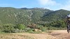
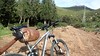
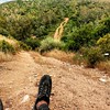
The above images may not be of the site on this page, but were taken nearby. They are loaded from Flickr so please click on them for image credits.
Click here to see more info for this site
Nearby sites
Click here to view sites on an interactive map of the areaKey: Red: member's photo, Blue: 3rd party photo, Yellow: other image, Green: no photo - please go there and take one, Grey: site destroyed
Download sites to:
KML (Google Earth)
GPX (GPS waypoints)
CSV (Garmin/Navman)
CSV (Excel)
To unlock full downloads you need to sign up as a Contributory Member. Otherwise downloads are limited to 50 sites.
Turn off the page maps and other distractions
Nearby sites listing. In the following links * = Image available
757m W 280° Bruncu Maletta Nuraghe Broch or Nuraghe
1.7km WSW 252° Santu Basileddu Domus de Janas Rock Cut Tomb
1.7km W 274° Taulaxia 2 Tomba di Giganti* Chambered Tomb
1.7km W 272° Taulaxia 1 Tomba di Giganti* Chambered Tomb
1.8km W 279° Pirreu Nuraghe* Broch or Nuraghe
2.1km WSW 259° Bruncu Su Castiu Nuraghe* Broch or Nuraghe
2.5km WSW 259° Masoni Porcus Nuraghe* Broch or Nuraghe
3.1km W 270° Bruncu Su Pisu Nuraghe* Broch or Nuraghe
3.2km W 263° Bruncu S'Allegau Nuraghe* Broch or Nuraghe
3.3km W 267° Sa Domu 'e S'Orcu Domus de Janas* Rock Cut Tomb
8.9km WSW 243° Cuccuru Nuraxi Complesso Nuragico Holy Well or Sacred Spring
10.6km SE 133° Tomba di giganti Sa Domu 'e s'Orcu* Chambered Tomb
10.9km NNW 344° Mitza Salamu Fonte Sardo-Punica* Holy Well or Sacred Spring
11.0km NNW 337° Su Tiriaxiu Tomba di Giganti* Chambered Tomb
11.6km NNW 343° Sa Domu 'e S'Orcu Nuraghe* Broch or Nuraghe
12.7km ESE 116° Monti Eccas Nuraghe Broch or Nuraghe
14.4km SSE 160° Diana Nuraghe* Broch or Nuraghe
15.0km SSE 150° Callitas Nuraghe* Broch or Nuraghe
15.1km SSE 151° Palisteri Nuraghe* Broch or Nuraghe
15.4km SSE 152° Tuvu Mannu Nuraghe* Broch or Nuraghe
17.1km SW 230° Cagliari Archaeological Museum* Museum
17.4km NNW 327° Mannu Nuraghe (Sant'Andrea Frius) Broch or Nuraghe
17.6km ESE 104° Antoni Usai Nuraghe Broch or Nuraghe
17.7km SW 234° Necropoli fenicio-punica di Tuvixeddu* Rock Cut Tomb
17.9km SW 228° Sant'Eulalia Area Archeologica* Ancient Village or Settlement
View more nearby sites and additional images


 We would like to know more about this location. Please feel free to add a brief description and any relevant information in your own language.
 Wir möchten mehr über diese Stätte erfahren. Bitte zögern Sie nicht, eine kurze Beschreibung und relevante Informationen in Deutsch hinzuzufügen.
 Nous aimerions en savoir encore un peu sur les lieux. S'il vous plaît n'hesitez pas à ajouter une courte description et tous les renseignements pertinents dans votre propre langue.
 Quisieramos informarnos un poco más de las lugares. No dude en añadir una breve descripción y otros datos relevantes en su propio idioma.