


<< Our Photo Pages >> Fossada Domus de Janas - Rock Cut Tomb in Italy in Sardinia (Sardegna)
Submitted by francescomanconi on Wednesday, 11 September 2019 Page Views: 430
Multi-periodSite Name: Fossada Domus de JanasCountry: Italy
NOTE: This site is 1.471 km away from the location you searched for.
Region: Sardinia (Sardegna) Type: Rock Cut Tomb
Nearest Town: Cagliari Nearest Village: Escalaplano
Latitude: 39.616301N Longitude: 9.332832E
Condition:
| 5 | Perfect |
| 4 | Almost Perfect |
| 3 | Reasonable but with some damage |
| 2 | Ruined but still recognisable as an ancient site |
| 1 | Pretty much destroyed, possibly visible as crop marks |
| 0 | No data. |
| -1 | Completely destroyed |
| 5 | Superb |
| 4 | Good |
| 3 | Ordinary |
| 2 | Not Good |
| 1 | Awful |
| 0 | No data. |
| 5 | Can be driven to, probably with disabled access |
| 4 | Short walk on a footpath |
| 3 | Requiring a bit more of a walk |
| 2 | A long walk |
| 1 | In the middle of nowhere, a nightmare to find |
| 0 | No data. |
| 5 | co-ordinates taken by GPS or official recorded co-ordinates |
| 4 | co-ordinates scaled from a detailed map |
| 3 | co-ordinates scaled from a bad map |
| 2 | co-ordinates of the nearest village |
| 1 | co-ordinates of the nearest town |
| 0 | no data |
Internal Links:
External Links:
")
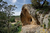
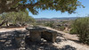
Group of 'Domus de janas' near the village of Escalaplano, cut in a beautiful rock.
You may be viewing yesterday's version of this page. To see the most up to date information please register for a free account.
")
Do not use the above information on other web sites or publications without permission of the contributor.
Nearby Images from Flickr
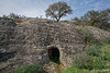
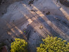
The above images may not be of the site on this page, but were taken nearby. They are loaded from Flickr so please click on them for image credits.
Click here to see more info for this site
Nearby sites
Click here to view sites on an interactive map of the areaKey: Red: member's photo, Blue: 3rd party photo, Yellow: other image, Green: no photo - please go there and take one, Grey: site destroyed
Download sites to:
KML (Google Earth)
GPX (GPS waypoints)
CSV (Garmin/Navman)
CSV (Excel)
To unlock full downloads you need to sign up as a Contributory Member. Otherwise downloads are limited to 50 sites.
Turn off the page maps and other distractions
Nearby sites listing. In the following links * = Image available
2.8km ENE 62° Perducatta Nuraghe Broch or Nuraghe
3.0km W 266° Su Gaffu Protonuraghe* Broch or Nuraghe
3.4km WSW 258° Sedda S'Amadori Nuraghe* Broch or Nuraghe
3.5km SSW 194° Amuai Nuraghe Broch or Nuraghe
4.2km W 277° Cranaxiolu Tomba di Giganti* Chambered Tomb
4.3km SSE 158° Funtana Coberta* Holy Well or Sacred Spring
4.6km NW 308° Taccu Piccinnu Nuraghe* Broch or Nuraghe
5.2km WNW 285° Crocoriga Nuraghe* Broch or Nuraghe
5.6km W 272° Tacchixeddu 2 Nuraghe* Broch or Nuraghe
5.6km NW 319° Su Putzu Pozzo Sacro* Holy Well or Sacred Spring
5.6km NW 319° Su Putzu Villaggio Nuragico* Ancient Village or Settlement
5.7km W 275° Tacchixeddu Villaggio Nuragico* Ancient Village or Settlement
5.8km W 275° Tacchixeddu 1 Nuraghe* Broch or Nuraghe
5.8km NW 317° De Pardu Nuraghe* Broch or Nuraghe
5.8km SW 235° Goni Nuraghe* Broch or Nuraghe
5.9km NNW 328° Su Pranu 1 Tomba di Giganti* Chambered Tomb
6.0km NNW 329° Arrubiu Nuraghe (Orroli)* Broch or Nuraghe
6.0km NW 322° Su Pranu 2 Nuraghe* Broch or Nuraghe
6.2km SW 232° Pranu Muteddu megalithic tombs II* Chambered Tomb
6.9km NNW 328° Su Pranu 2 Tomba di Giganti* Chambered Tomb
6.9km SW 230° Serrionis Domus de Janas* Rock Cut Tomb
7.0km NW 324° Cracuri Nuraghe* Broch or Nuraghe
7.1km NNW 336° Su Pranu 1 Nuraghe* Broch or Nuraghe
7.3km NE 45° Is Clamoris Fonte Nuragica* Holy Well or Sacred Spring
7.5km NW 320° Santa Caterina Domus de Janas* Rock Cut Tomb
View more nearby sites and additional images


 We would like to know more about this location. Please feel free to add a brief description and any relevant information in your own language.
 Wir möchten mehr über diese Stätte erfahren. Bitte zögern Sie nicht, eine kurze Beschreibung und relevante Informationen in Deutsch hinzuzufügen.
 Nous aimerions en savoir encore un peu sur les lieux. S'il vous plaît n'hesitez pas à ajouter une courte description et tous les renseignements pertinents dans votre propre langue.
 Quisieramos informarnos un poco más de las lugares. No dude en añadir una breve descripción y otros datos relevantes en su propio idioma.