 with our Megalithic Portal iPhone app")


<< Our Photo Pages >> Padentes Tomba di Giganti - Chambered Tomb in Italy in Sardinia (Sardegna)
Submitted by SolarMegalith on Friday, 28 April 2017 Page Views: 1148
Neolithic and Bronze AgeSite Name: Padentes Tomba di GigantiCountry: Italy
NOTE: This site is 0.848 km away from the location you searched for.
Region: Sardinia (Sardegna) Type: Chambered Tomb
Nearest Town: Ala dei Sardi
Latitude: 40.658991N Longitude: 9.329833E
Condition:
| 5 | Perfect |
| 4 | Almost Perfect |
| 3 | Reasonable but with some damage |
| 2 | Ruined but still recognisable as an ancient site |
| 1 | Pretty much destroyed, possibly visible as crop marks |
| 0 | No data. |
| -1 | Completely destroyed |
| 5 | Superb |
| 4 | Good |
| 3 | Ordinary |
| 2 | Not Good |
| 1 | Awful |
| 0 | No data. |
| 5 | Can be driven to, probably with disabled access |
| 4 | Short walk on a footpath |
| 3 | Requiring a bit more of a walk |
| 2 | A long walk |
| 1 | In the middle of nowhere, a nightmare to find |
| 0 | No data. |
| 5 | co-ordinates taken by GPS or official recorded co-ordinates |
| 4 | co-ordinates scaled from a detailed map |
| 3 | co-ordinates scaled from a bad map |
| 2 | co-ordinates of the nearest village |
| 1 | co-ordinates of the nearest town |
| 0 | no data |
Internal Links:
External Links:
I have visited· I would like to visit
SolarMegalith visited on 6th Apr 2017 - their rating: Cond: 2 Amb: 4 Access: 4
")
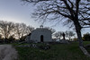
The Giants' Tomb (tomba di giganti) of Padentes is located north of Ala dei Sardi. The elongated burial chamber survived, but all of its capstones are gone. Remains of the exedra are visible, including a flat block which might be part of a broken stele.
You may be viewing yesterday's version of this page. To see the most up to date information please register for a free account.
")
")
")
Do not use the above information on other web sites or publications without permission of the contributor.
Nearby Images from Flickr

The above images may not be of the site on this page, but were taken nearby. They are loaded from Flickr so please click on them for image credits.
Click here to see more info for this site
Nearby sites
Click here to view sites on an interactive map of the areaKey: Red: member's photo, Blue: 3rd party photo, Yellow: other image, Green: no photo - please go there and take one, Grey: site destroyed
Download sites to:
KML (Google Earth)
GPX (GPS waypoints)
CSV (Garmin/Navman)
CSV (Excel)
To unlock full downloads you need to sign up as a Contributory Member. Otherwise downloads are limited to 50 sites.
Turn off the page maps and other distractions
Nearby sites listing. In the following links * = Image available
2.0km WNW 290° Maone Dolmen Burial Chamber or Dolmen
2.7km SE 146° Boddo Nuraghe* Broch or Nuraghe
2.8km WSW 257° Malacarruca Tomba di Giganti* Chambered Tomb
3.4km SW 229° Intro 'e Serra Nuraghe* Broch or Nuraghe
3.8km NNW 337° Sos Nurattolos Temple Ancient Temple
3.8km NNW 337° Sos Nurattolos Settlement Ancient Village or Settlement
4.0km E 91° Poddialvu Nuraghe Broch or Nuraghe
4.8km SW 225° Inione Nuraghe* Broch or Nuraghe
10.1km S 187° Loelle Nuraghe* Broch or Nuraghe
10.4km S 186° Loelle Stonerow* Stone Row / Alignment
10.5km S 186° Loelle Tomba di Giganti* Chambered Tomb
12.1km SSW 195° Sa Janna 'e Su Laccu Dolmen* Burial Chamber or Dolmen
14.3km S 181° Romanzesu Villaggio Santuario* Ancient Village or Settlement
16.0km ESE 120° Liri Nuraghe Broch or Nuraghe
16.2km WSW 239° Lerno Nuraghe Broch or Nuraghe
16.2km NW 305° S'Arroccu Nuraghe Broch or Nuraghe
16.3km WNW 303° Malghesi Domus de Janas* Rock Cut Tomb
16.7km ESE 114° Gianna Oriavula Domus de Janas* Rock Cut Tomb
17.2km SSW 206° Usanis Nuraghe* Broch or Nuraghe
17.4km ESE 119° Monte Prana Tomba Dolmenica* Burial Chamber or Dolmen
17.4km ESE 119° Monte Prana Muraglia Megalitica* Stone Fort or Dun
18.2km SE 126° Thorra Tomba di Giganti Chambered Tomb
18.2km SE 126° Thorra Nuraghe Broch or Nuraghe
18.5km SSW 205° S'Iscobalzu Nuraghe* Broch or Nuraghe
18.5km SSW 214° Merula Nuraghe* Broch or Nuraghe
View more nearby sites and additional images


 We would like to know more about this location. Please feel free to add a brief description and any relevant information in your own language.
 Wir möchten mehr über diese Stätte erfahren. Bitte zögern Sie nicht, eine kurze Beschreibung und relevante Informationen in Deutsch hinzuzufügen.
 Nous aimerions en savoir encore un peu sur les lieux. S'il vous plaît n'hesitez pas à ajouter une courte description et tous les renseignements pertinents dans votre propre langue.
 Quisieramos informarnos un poco más de las lugares. No dude en añadir una breve descripción y otros datos relevantes en su propio idioma.