 with our Megalithic Portal iPhone app")


<< Text Pages >> Tomeone Nuraghe - Broch or Nuraghe in Italy in Sardinia (Sardegna)
Submitted by SolarMegalith on Thursday, 14 October 2010 Page Views: 1507
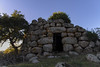
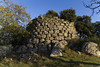
Neolithic and Bronze AgeSite Name: Tomeone NuragheCountry: Italy
NOTE: This site is 1.338 km away from the location you searched for.
Region: Sardinia (Sardegna) Type: Broch or Nuraghe
Nearest Town: Nule
Latitude: 40.474830N Longitude: 9.194960E
Condition:
| 5 | Perfect |
| 4 | Almost Perfect |
| 3 | Reasonable but with some damage |
| 2 | Ruined but still recognisable as an ancient site |
| 1 | Pretty much destroyed, possibly visible as crop marks |
| 0 | No data. |
| -1 | Completely destroyed |
| 5 | Superb |
| 4 | Good |
| 3 | Ordinary |
| 2 | Not Good |
| 1 | Awful |
| 0 | No data. |
| 5 | Can be driven to, probably with disabled access |
| 4 | Short walk on a footpath |
| 3 | Requiring a bit more of a walk |
| 2 | A long walk |
| 1 | In the middle of nowhere, a nightmare to find |
| 0 | No data. |
| 5 | co-ordinates taken by GPS or official recorded co-ordinates |
| 4 | co-ordinates scaled from a detailed map |
| 3 | co-ordinates scaled from a bad map |
| 2 | co-ordinates of the nearest village |
| 1 | co-ordinates of the nearest town |
| 0 | no data |
Internal Links:
External Links:
I have visited· I would like to visit
msinfo has visited here
You may be viewing yesterday's version of this page. To see the most up to date information please register for a free account.
Do not use the above information on other web sites or publications without permission of the contributor.
Nearby Images from Flickr

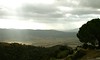
The above images may not be of the site on this page, but were taken nearby. They are loaded from Flickr so please click on them for image credits.
Click here to see more info for this site
Nearby sites
Click here to view sites on an interactive map of the areaKey: Red: member's photo, Blue: 3rd party photo, Yellow: other image, Green: no photo - please go there and take one, Grey: site destroyed
Download sites to:
KML (Google Earth)
GPX (GPS waypoints)
CSV (Garmin/Navman)
CSV (Excel)
To unlock full downloads you need to sign up as a Contributory Member. Otherwise downloads are limited to 50 sites.
Turn off the page maps and other distractions
Nearby sites listing. In the following links * = Image available
961m ESE 103° Arile Nuraghe* Broch or Nuraghe
3.3km ENE 62° Laonidde Nuraghe* Broch or Nuraghe
4.1km SW 217° Sos Molimentos Domus de Janas* Rock Cut Tomb
4.2km WSW 246° S'Aspru Nuraghe Broch or Nuraghe
4.4km WNW 294° Ortuine Nuraghe Broch or Nuraghe
4.5km E 84° Voes Nuraghe* Broch or Nuraghe
4.6km W 260° Ena'e Sedina Nuraghe Broch or Nuraghe
4.7km WNW 300° Sae Maria Luisa Nuraghe Broch or Nuraghe
4.7km W 278° Bodoi Nuraghe Broch or Nuraghe
4.8km WNW 288° Ortuineddu Nuraghe Broch or Nuraghe
5.2km NNE 13° Merula Nuraghe* Broch or Nuraghe
5.2km NE 45° S'Iscobalzu Nuraghe* Broch or Nuraghe
6.3km NE 36° Usanis Nuraghe* Broch or Nuraghe
7.0km NNW 347° Su Carru Nuraghe* Broch or Nuraghe
7.1km W 267° Nurchidda Nuraghe Broch or Nuraghe
8.5km SW 229° San Saturnino Nuraghe* Broch or Nuraghe
9.6km SW 233° Merenda Ona Tomba di Giganti Chambered Tomb
9.6km W 265° Gurzu Nuraghe Broch or Nuraghe
10.2km W 263° Ainas Nuraghe Broch or Nuraghe
12.0km NE 43° Sa Janna 'e Su Laccu Dolmen* Burial Chamber or Dolmen
12.3km SE 142° Complesso nuragico di Noddule* Ancient Village or Settlement
12.3km W 271° Tilariga Nuraghe* Broch or Nuraghe
12.4km NNW 348° Lerno Nuraghe Broch or Nuraghe
12.7km ENE 61° Romanzesu Villaggio Santuario* Ancient Village or Settlement
12.8km NW 314° Norchetta Nuraghe Broch or Nuraghe
View more nearby sites and additional images


 We would like to know more about this location. Please feel free to add a brief description and any relevant information in your own language.
 Wir möchten mehr über diese Stätte erfahren. Bitte zögern Sie nicht, eine kurze Beschreibung und relevante Informationen in Deutsch hinzuzufügen.
 Nous aimerions en savoir encore un peu sur les lieux. S'il vous plaît n'hesitez pas à ajouter une courte description et tous les renseignements pertinents dans votre propre langue.
 Quisieramos informarnos un poco más de las lugares. No dude en añadir una breve descripción y otros datos relevantes en su propio idioma.