


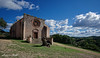
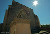
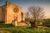
<< Our Photo Pages >> Talei Protonuraghe - Broch or Nuraghe in Italy in Sardinia (Sardegna)
Submitted by SolarMegalith on Thursday, 24 May 2012 Page Views: 4763
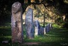
Neolithic and Bronze AgeSite Name: Talei Protonuraghe Alternative Name: Nuraghe TaleiCountry: Italy Region: Sardinia (Sardegna) Type: Broch or Nuraghe
Nearest Town: Sorgono
Latitude: 40.008322N Longitude: 9.044655E
Condition:
| 5 | Perfect |
| 4 | Almost Perfect |
| 3 | Reasonable but with some damage |
| 2 | Ruined but still recognisable as an ancient site |
| 1 | Pretty much destroyed, possibly visible as crop marks |
| 0 | No data. |
| -1 | Completely destroyed |
| 5 | Superb |
| 4 | Good |
| 3 | Ordinary |
| 2 | Not Good |
| 1 | Awful |
| 0 | No data. |
| 5 | Can be driven to, probably with disabled access |
| 4 | Short walk on a footpath |
| 3 | Requiring a bit more of a walk |
| 2 | A long walk |
| 1 | In the middle of nowhere, a nightmare to find |
| 0 | No data. |
| 5 | co-ordinates taken by GPS or official recorded co-ordinates |
| 4 | co-ordinates scaled from a detailed map |
| 3 | co-ordinates scaled from a bad map |
| 2 | co-ordinates of the nearest village |
| 1 | co-ordinates of the nearest town |
| 0 | no data |
Internal Links:
External Links:
I have visited· I would like to visit
SolarMegalith visited on 10th May 2012 - their rating: Cond: 4 Amb: 4 Access: 3
")
Protonuraghe Talei has been excavated in 1981 – the sherds of the Bronze Age "Sa Turricula" style pottery were discovered.
The monument is not easy to find, as it is surrounded with trees and not signposted. To reach it you have to turn from the road Ortueri-Sorgono towards San Mauro church – the monument is located in your right on slope of the hill. SW from the protonuraghe there are remains of Tomba di Giganti, the megalithic tomb from Nuragic period.
You may be viewing yesterday's version of this page. To see the most up to date information please register for a free account.
")
")
")
")
Do not use the above information on other web sites or publications without permission of the contributor.
Nearby Images from Flickr
![Menhir di Biru'e Concas (Sorgono) [on Explore april 5, 2022]](https://farm66.static.flickr.com/65535/51981796989_93c9ae94fd_t.jpg)
The above images may not be of the site on this page, but were taken nearby. They are loaded from Flickr so please click on them for image credits.
Click here to see more info for this site
Nearby sites
Click here to view sites on an interactive map of the areaKey: Red: member's photo, Blue: 3rd party photo, Yellow: other image, Green: no photo - please go there and take one, Grey: site destroyed
Download sites to:
KML (Google Earth)
GPX (GPS waypoints)
CSV (Garmin/Navman)
CSV (Excel)
To unlock full downloads you need to sign up as a Contributory Member. Otherwise downloads are limited to 50 sites.
Turn off the page maps and other distractions
Nearby sites listing. In the following links * = Image available
143m WSW 245° Talei Tomba di Giganti* Chambered Tomb
1.1km WNW 284° Biru 'e Concas Allineamenti* Multiple Stone Rows / Avenue
1.4km WNW 289° Biru 'e Concas Nuraghe* Broch or Nuraghe
1.7km NNE 22° Crebos Nuraghe Broch or Nuraghe
4.4km SW 222° Accoro Nuedda Nuraghe* Broch or Nuraghe
5.9km WNW 290° Su Linnari Nuraghe Broch or Nuraghe
5.9km SSW 205° Abbagadda Nuraghe* Broch or Nuraghe
6.8km WNW 286° Pira 'e Zuri Nuraghe Broch or Nuraghe
9.5km ESE 111° Nadalia Domus de Janas* Rock Cut Tomb
10.4km SSE 167° Nolza Nuraghe* Broch or Nuraghe
10.7km NNE 28° Alinedu Nuraghe* Broch or Nuraghe
10.9km ESE 112° Lagosu Domus de Janas* Rock Cut Tomb
11.1km SW 234° Cuccuru e Lai* Sculptured Stone
12.2km SSW 192° Genna Corte Nuraghe* Broch or Nuraghe
12.3km ESE 118° Antonitzo Domus de Janas* Rock Cut Tomb
12.4km NE 43° Mancosu Domus de Janas* Rock Cut Tomb
12.6km S 189° Picciu Nuraghe* Broch or Nuraghe
12.7km SSW 197° Orrubiu Nuraghe Broch or Nuraghe
12.8km SSW 192° Masone Perdu* Chambered Tomb
12.9km NW 323° S'Angrone Domus de Janas* Rock Cut Tomb
13.0km S 190° Corte Noa Menhir I* Standing Stone (Menhir)
13.1km S 189° Corte Noa Dolmen* Burial Chamber or Dolmen
13.1km W 277° Marapela Nuraghe Broch or Nuraghe
13.2km S 190° Corte Noa Stone row* Stone Row / Alignment
13.3km NW 315° Monte Calighe Domus de Janas Rock Cut Tomb
View more nearby sites and additional images


 We would like to know more about this location. Please feel free to add a brief description and any relevant information in your own language.
 Wir möchten mehr über diese Stätte erfahren. Bitte zögern Sie nicht, eine kurze Beschreibung und relevante Informationen in Deutsch hinzuzufügen.
 Nous aimerions en savoir encore un peu sur les lieux. S'il vous plaît n'hesitez pas à ajouter une courte description et tous les renseignements pertinents dans votre propre langue.
 Quisieramos informarnos un poco más de las lugares. No dude en añadir una breve descripción y otros datos relevantes en su propio idioma.