


<< Text Pages >> Renaghju coffre - Burial Chamber or Dolmen in France in Corsica:Corse-Sud (2A)
Submitted by TheCaptain on Wednesday, 08 September 2010 Page Views: 2730
Neolithic and Bronze AgeSite Name: Renaghju coffreCountry: France
NOTE: This site is 7.395 km away from the location you searched for.
Département: Corsica:Corse-Sud (2A) Type: Burial Chamber or Dolmen
Nearest Town: Ajaccio Nearest Village: Sartene
Latitude: 41.527000N Longitude: 8.925000E
Condition:
| 5 | Perfect |
| 4 | Almost Perfect |
| 3 | Reasonable but with some damage |
| 2 | Ruined but still recognisable as an ancient site |
| 1 | Pretty much destroyed, possibly visible as crop marks |
| 0 | No data. |
| -1 | Completely destroyed |
| 5 | Superb |
| 4 | Good |
| 3 | Ordinary |
| 2 | Not Good |
| 1 | Awful |
| 0 | No data. |
| 5 | Can be driven to, probably with disabled access |
| 4 | Short walk on a footpath |
| 3 | Requiring a bit more of a walk |
| 2 | A long walk |
| 1 | In the middle of nowhere, a nightmare to find |
| 0 | No data. |
| 5 | co-ordinates taken by GPS or official recorded co-ordinates |
| 4 | co-ordinates scaled from a detailed map |
| 3 | co-ordinates scaled from a bad map |
| 2 | co-ordinates of the nearest village |
| 1 | co-ordinates of the nearest town |
| 0 | no data |
Be the first person to rate this site - see the 'Contribute!' box in the right hand menu.
Internal Links:
External Links:
Coffre in Corse:Corse-Sud (2A)
Renaghju coffre is a Coffre in the community of Sartene, Departement of Corse du Sud, Region of Corse
You may be viewing yesterday's version of this page. To see the most up to date information please register for a free account.
Do not use the above information on other web sites or publications without permission of the contributor.
Nearby Images from Flickr
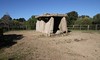
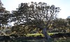
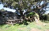
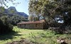
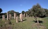
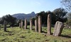
The above images may not be of the site on this page, but were taken nearby. They are loaded from Flickr so please click on them for image credits.
Click here to see more info for this site
Nearby sites
Click here to view sites on an interactive map of the areaKey: Red: member's photo, Blue: 3rd party photo, Yellow: other image, Green: no photo - please go there and take one, Grey: site destroyed
Download sites to:
KML (Google Earth)
GPX (GPS waypoints)
CSV (Garmin/Navman)
CSV (Excel)
To unlock full downloads you need to sign up as a Contributory Member. Otherwise downloads are limited to 50 sites.
Turn off the page maps and other distractions
Nearby sites listing. In the following links * = Image available
314m W 262° Renaju alignement* Stone Row / Alignment
460m NW 324° Stantari Alignement* Stone Row / Alignment
631m WNW 296° Fontanaccia Dolmen* Burial Chamber or Dolmen
2.9km NNE 15° Pastini stone circle Stone Circle
3.7km NNE 21° Cardiccia Dolmen Burial Chamber or Dolmen
4.6km NW 316° Palaggiu alignement* Stone Row / Alignment
4.6km WNW 298° Appazu menhirs* Stone Row / Alignment
4.7km WNW 297° Appazu Dolmen Burial Chamber or Dolmen
8.5km NNW 331° Vaccil-Vecchiu menhir* Standing Stone (Menhir)
9.1km NNW 335° Bizzicu Rossu dolmen Burial Chamber or Dolmen
9.8km NNW 347° Alo Bisuje* Stone Fort or Dun
9.8km NNW 337° Timozzolo menhirs Standing Stones
9.9km NNW 336° Cuntrasarda coffre Burial Chamber or Dolmen
9.9km NNW 336° Campu Fiorellu dolmen Burial Chamber or Dolmen
9.9km NNW 337° Zalavone menhirs Standing Stones
10.0km NNW 336° Speranzata dolmen Burial Chamber or Dolmen
10.0km NNW 337° A Piana menhirs Standing Stones
10.1km NNW 337° Pazzanile dolmen Burial Chamber or Dolmen
10.1km NNW 336° Campo-Fiorello menhirs Standing Stones
11.1km NNE 21° Palaghju coffre Burial Chamber or Dolmen
11.2km NNE 20° Arghjola dolmen Burial Chamber or Dolmen
11.2km NNE 21° Musée de Sartène* Museum
11.2km NNE 21° Curgia statue-menhir Sculptured Stone
11.3km NNE 21° Rizzanezze statue-menhir Sculptured Stone
11.3km NNE 21° Petra Pinzuta statue-menhir Sculptured Stone
View more nearby sites and additional images


 We would like to know more about this location. Please feel free to add a brief description and any relevant information in your own language.
 Wir möchten mehr über diese Stätte erfahren. Bitte zögern Sie nicht, eine kurze Beschreibung und relevante Informationen in Deutsch hinzuzufügen.
 Nous aimerions en savoir encore un peu sur les lieux. S'il vous plaît n'hesitez pas à ajouter une courte description et tous les renseignements pertinents dans votre propre langue.
 Quisieramos informarnos un poco más de las lugares. No dude en añadir una breve descripción y otros datos relevantes en su propio idioma.