


<< Our Photo Pages >> Accoro Nuedda Nuraghe - Broch or Nuraghe in Italy in Sardinia (Sardegna)
Submitted by francescomanconi on Wednesday, 01 August 2012 Page Views: 2682
Neolithic and Bronze AgeSite Name: Accoro Nuedda NuragheCountry: Italy
NOTE: This site is 2.489 km away from the location you searched for.
Region: Sardinia (Sardegna) Type: Broch or Nuraghe
Nearest Town: Samugheo
Latitude: 39.978889N Longitude: 9.009722E
Condition:
| 5 | Perfect |
| 4 | Almost Perfect |
| 3 | Reasonable but with some damage |
| 2 | Ruined but still recognisable as an ancient site |
| 1 | Pretty much destroyed, possibly visible as crop marks |
| 0 | No data. |
| -1 | Completely destroyed |
| 5 | Superb |
| 4 | Good |
| 3 | Ordinary |
| 2 | Not Good |
| 1 | Awful |
| 0 | No data. |
| 5 | Can be driven to, probably with disabled access |
| 4 | Short walk on a footpath |
| 3 | Requiring a bit more of a walk |
| 2 | A long walk |
| 1 | In the middle of nowhere, a nightmare to find |
| 0 | No data. |
| 5 | co-ordinates taken by GPS or official recorded co-ordinates |
| 4 | co-ordinates scaled from a detailed map |
| 3 | co-ordinates scaled from a bad map |
| 2 | co-ordinates of the nearest village |
| 1 | co-ordinates of the nearest town |
| 0 | no data |
Internal Links:
External Links:
")
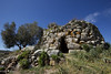
Nuraghe in granite stones which preserves the main tower.
You may be viewing yesterday's version of this page. To see the most up to date information please register for a free account.
Do not use the above information on other web sites or publications without permission of the contributor.
Nearby Images from Flickr
The above images may not be of the site on this page, but were taken nearby. They are loaded from Flickr so please click on them for image credits.
Click here to see more info for this site
Nearby sites
Click here to view sites on an interactive map of the areaKey: Red: member's photo, Blue: 3rd party photo, Yellow: other image, Green: no photo - please go there and take one, Grey: site destroyed
Download sites to:
KML (Google Earth)
GPX (GPS waypoints)
CSV (Garmin/Navman)
CSV (Excel)
To unlock full downloads you need to sign up as a Contributory Member. Otherwise downloads are limited to 50 sites.
Turn off the page maps and other distractions
Nearby sites listing. In the following links * = Image available
2.1km SSE 166° Abbagadda Nuraghe* Broch or Nuraghe
4.0km NNE 28° Biru 'e Concas Allineamenti* Multiple Stone Rows / Avenue
4.1km NNE 24° Biru 'e Concas Nuraghe* Broch or Nuraghe
4.3km NE 42° Talei Tomba di Giganti* Chambered Tomb
4.4km NE 42° Talei Protonuraghe* Broch or Nuraghe
5.8km NNW 334° Su Linnari Nuraghe Broch or Nuraghe
6.0km NE 37° Crebos Nuraghe Broch or Nuraghe
6.3km NW 326° Pira 'e Zuri Nuraghe Broch or Nuraghe
6.8km WSW 241° Cuccuru e Lai* Sculptured Stone
8.6km S 178° Genna Corte Nuraghe* Broch or Nuraghe
8.7km SE 142° Nolza Nuraghe* Broch or Nuraghe
8.9km S 185° Orrubiu Nuraghe Broch or Nuraghe
9.2km S 173° Picciu Nuraghe* Broch or Nuraghe
9.3km S 178° Masone Perdu* Chambered Tomb
9.6km S 176° Corte Noa Menhir I* Standing Stone (Menhir)
9.7km WSW 258° Sa Mura Nuraghe (Samugheo) Broch or Nuraghe
9.7km S 174° Corte Noa Dolmen* Burial Chamber or Dolmen
9.8km S 176° Corte Noa Stone row* Stone Row / Alignment
10.0km S 176° Perda Iddocca* Standing Stones
11.1km S 176° Verra Nuraghe Broch or Nuraghe
11.2km WNW 296° Marapela Nuraghe Broch or Nuraghe
11.7km WNW 295° Sa Giacca Protonuraghe Broch or Nuraghe
11.8km E 91° Nadalia Domus de Janas* Rock Cut Tomb
11.8km W 265° Arasseda Nuraghe Broch or Nuraghe
12.2km SW 234° Mesadda Domus de Janas* Rock Cut Tomb
View more nearby sites and additional images


 We would like to know more about this location. Please feel free to add a brief description and any relevant information in your own language.
 Wir möchten mehr über diese Stätte erfahren. Bitte zögern Sie nicht, eine kurze Beschreibung und relevante Informationen in Deutsch hinzuzufügen.
 Nous aimerions en savoir encore un peu sur les lieux. S'il vous plaît n'hesitez pas à ajouter une courte description et tous les renseignements pertinents dans votre propre langue.
 Quisieramos informarnos un poco más de las lugares. No dude en añadir una breve descripción y otros datos relevantes en su propio idioma.