


<< Our Photo Pages >> Bindu Sagar - Ancient Temple in India
Submitted by motist on Thursday, 15 March 2007 Page Views: 4428
Multi-periodSite Name: Bindu SagarCountry: India
NOTE: This site is 1.81 km away from the location you searched for.
Type: Ancient Temple
Latitude: 20.241953N Longitude: 85.835043E
Condition:
| 5 | Perfect |
| 4 | Almost Perfect |
| 3 | Reasonable but with some damage |
| 2 | Ruined but still recognisable as an ancient site |
| 1 | Pretty much destroyed, possibly visible as crop marks |
| 0 | No data. |
| -1 | Completely destroyed |
| 5 | Superb |
| 4 | Good |
| 3 | Ordinary |
| 2 | Not Good |
| 1 | Awful |
| 0 | No data. |
| 5 | Can be driven to, probably with disabled access |
| 4 | Short walk on a footpath |
| 3 | Requiring a bit more of a walk |
| 2 | A long walk |
| 1 | In the middle of nowhere, a nightmare to find |
| 0 | No data. |
| 5 | co-ordinates taken by GPS or official recorded co-ordinates |
| 4 | co-ordinates scaled from a detailed map |
| 3 | co-ordinates scaled from a bad map |
| 2 | co-ordinates of the nearest village |
| 1 | co-ordinates of the nearest town |
| 0 | no data |
Internal Links:
External Links:
")
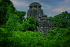
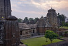
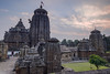
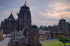
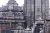
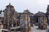
Bindu Sagar, Bhubaneshwar, Orissa
Bindu Sagar or the Ocean Drop Tank, lying just north of the Lingaraj temple, is said to contain water from every holy stream, pool and tank in India - obviously a good place to wash away sin. There are a number of temples and shrines scattered around the tank(+- 700). In the centre of the tank is a water pavilion where, once a year, the Lingaraj temple's deity is brought for ritual bathing.
You may be viewing yesterday's version of this page. To see the most up to date information please register for a free account.
Do not use the above information on other web sites or publications without permission of the contributor.
Nearby Images from Flickr
The above images may not be of the site on this page, but were taken nearby. They are loaded from Flickr so please click on them for image credits.
Click here to see more info for this site
Nearby sites
Click here to view sites on an interactive map of the areaKey: Red: member's photo, Blue: 3rd party photo, Yellow: other image, Green: no photo - please go there and take one, Grey: site destroyed
Download sites to:
KML (Google Earth)
GPX (GPS waypoints)
CSV (Garmin/Navman)
CSV (Excel)
To unlock full downloads you need to sign up as a Contributory Member. Otherwise downloads are limited to 50 sites.
Turn off the page maps and other distractions
Nearby sites listing. In the following links * = Image available
400m WSW 242° Lingraj temple* Ancient Temple
540m E 87° Kedar Gouri Temple* Ancient Temple
567m E 81° Mukteshwar Temple* Ancient Temple
703m ENE 66° Parsusrameswar temple* Ancient Temple
716m S 180° Brahmeshwara temple* Ancient Temple
908m E 80° Rajarani temple* Ancient Temple
4.4km NW 316° Vaital temple* Ancient Temple
5.6km WNW 294° Udayagiri and Khandagiri Cave Temples* Ancient Temple
5.6km WNW 294° Udaigiri Caves* Cave or Rock Shelter
47.8km SE 145° Konarak sun temple* Ancient Temple
258.9km N 360° Chaibasa Standing Stones
275.0km NW 312° Ulapgarh Ushakuthi Rock Art
276.6km NW 310° Vikramkhol Rock Art
325.7km N 2° Chokahatu* Barrow Cemetery
408.3km N 352° Punkri Burwadih* Chambered Tomb
419.2km N 354° Rola.* Standing Stones
427.9km N 0° Dhekia Pathar* Burial Chamber or Dolmen
449.0km WNW 282° Tarighat* Ancient Village or Settlement
535.6km N 352° Barabar Caves* Cave or Rock Shelter
545.8km N 356° Nalanda University excavated site* Ancient Temple
554.2km NNW 329° Obra standing stones Standing Stones
558.2km N 353° Telhara Ancient Temple
636.3km NE 34° Mahasthangarh Ancient Village or Settlement
648.5km NE 50° Wari-Bateswar Ancient Village or Settlement
693.3km SW 234° Undavalli cave temple* Ancient Temple
View more nearby sites and additional images

")
 We would like to know more about this location. Please feel free to add a brief description and any relevant information in your own language.
 Wir möchten mehr über diese Stätte erfahren. Bitte zögern Sie nicht, eine kurze Beschreibung und relevante Informationen in Deutsch hinzuzufügen.
 Nous aimerions en savoir encore un peu sur les lieux. S'il vous plaît n'hesitez pas à ajouter une courte description et tous les renseignements pertinents dans votre propre langue.
 Quisieramos informarnos un poco más de las lugares. No dude en añadir una breve descripción y otros datos relevantes en su propio idioma.