

<< Text Pages >> Mandalagiri Vihara - Ancient Temple in Sri Lanka
Submitted by KaiHofmann on Tuesday, 08 September 2015 Page Views: 1252
Multi-periodSite Name: Mandalagiri ViharaCountry: Sri Lanka
NOTE: This site is 17.436 km away from the location you searched for.
Type: Ancient Temple
Nearest Town: Medirigiriya
Latitude: 8.156139N Longitude: 80.996137E
Condition:
| 5 | Perfect |
| 4 | Almost Perfect |
| 3 | Reasonable but with some damage |
| 2 | Ruined but still recognisable as an ancient site |
| 1 | Pretty much destroyed, possibly visible as crop marks |
| 0 | No data. |
| -1 | Completely destroyed |
| 5 | Superb |
| 4 | Good |
| 3 | Ordinary |
| 2 | Not Good |
| 1 | Awful |
| 0 | No data. |
| 5 | Can be driven to, probably with disabled access |
| 4 | Short walk on a footpath |
| 3 | Requiring a bit more of a walk |
| 2 | A long walk |
| 1 | In the middle of nowhere, a nightmare to find |
| 0 | No data. |
| 5 | co-ordinates taken by GPS or official recorded co-ordinates |
| 4 | co-ordinates scaled from a detailed map |
| 3 | co-ordinates scaled from a bad map |
| 2 | co-ordinates of the nearest village |
| 1 | co-ordinates of the nearest town |
| 0 | no data |
Internal Links:
External Links:
Ancient Temple in Sri Lanka
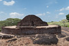
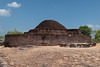
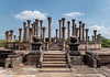
The nice Mandalagiri Vihara is famous for his Vatadage. This is a kind of stupa house. It is pretty well preserved, with still four sitting buddha statues und many pillars. It looks similar to the famous Vatadage of Polonaruva ancient city. There are also some othe statues an stupas to see at this beautiful site.
You may be viewing yesterday's version of this page. To see the most up to date information please register for a free account.
Do not use the above information on other web sites or publications without permission of the contributor.
Nearby Images from Flickr
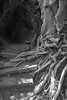

The above images may not be of the site on this page, but were taken nearby. They are loaded from Flickr so please click on them for image credits.
Click here to see more info for this site
Nearby sites
Click here to view sites on an interactive map of the areaKey: Red: member's photo, Blue: 3rd party photo, Yellow: other image, Green: no photo - please go there and take one, Grey: site destroyed
Download sites to:
KML (Google Earth)
GPX (GPS waypoints)
CSV (Garmin/Navman)
CSV (Excel)
To unlock full downloads you need to sign up as a Contributory Member. Otherwise downloads are limited to 50 sites.
Turn off the page maps and other distractions
Nearby sites listing. In the following links * = Image available
23.2km S 179° Polonnaruwa* Ancient Village or Settlement
34.2km SW 230° Sigiriya* Hillfort
36.7km W 262° Ritigala Ancient Temple
42.9km NE 56° Seruvila Mangala Raja Maha Viharaya* Ancient Temple
50.8km SW 229° Dambula Cave temple* Cave or Rock Shelter
53.7km SW 229° Ibbankatuwa Megalithic Cemetery Cist
54.8km NNE 30° Koneswaram Kovil* Ancient Temple
55.6km WSW 253° Aukana Buddha* Sculptured Stone
57.2km WNW 292° Mihintale Temple* Ancient Temple
57.7km NNE 19° Velgam Vehera Ancient Temple
66.2km WSW 254° Sasseruwa* Sculptured Stone
66.5km SW 216° Nalanda Gedige* Ancient Temple
68.8km WNW 288° Anuradhapura* Ancient Village or Settlement
79.4km N 1° Girihandu Seya Ancient Temple
93.8km WNW 300° Tantirimale Ancient Temple
100.8km SE 137° Rajagala Kanda Ancient Temple
114.1km SW 217° Gal Messa of Padavigampola* Burial Chamber or Dolmen
130.4km SE 138° Deegavapi Dagoba Ancient Temple
137.5km S 189° Seetha Amman Temple* Modern Stone Circle etc
143.8km S 178° Ravana Ella Cave Cave or Rock Shelter
144.6km S 179° Dowa Rajamaha Viharaya Ancient Temple
153.4km SSE 158° Wattumbegoda cave Rock Art
159.2km SSE 168° Dematamal Viharaya* Ancient Temple
159.5km SSW 200° Adam's Peak* Natural Stone / Erratic / Other Natural Feature
163.3km S 176° Weherayaya Dagoba* Ancient Temple
View more nearby sites and additional images


 We would like to know more about this location. Please feel free to add a brief description and any relevant information in your own language.
 Wir möchten mehr über diese Stätte erfahren. Bitte zögern Sie nicht, eine kurze Beschreibung und relevante Informationen in Deutsch hinzuzufügen.
 Nous aimerions en savoir encore un peu sur les lieux. S'il vous plaît n'hesitez pas à ajouter une courte description et tous les renseignements pertinents dans votre propre langue.
 Quisieramos informarnos un poco más de las lugares. No dude en añadir una breve descripción y otros datos relevantes en su propio idioma.