

, Aubrey Burl")
<< Our Photo Pages >> Adam's Peak - Natural Stone / Erratic / Other Natural Feature in Sri Lanka
Submitted by KaiHofmann on Thursday, 28 August 2014 Page Views: 1726
Natural PlacesSite Name: Adam's Peak Alternative Name: Sri Paadaya PeakCountry: Sri Lanka
NOTE: This site is 1.797 km away from the location you searched for.
Type: Natural Stone / Erratic / Other Natural Feature
Nearest Town: Nuwara Eliya
Latitude: 6.808300N Longitude: 80.500000E
Condition:
| 5 | Perfect |
| 4 | Almost Perfect |
| 3 | Reasonable but with some damage |
| 2 | Ruined but still recognisable as an ancient site |
| 1 | Pretty much destroyed, possibly visible as crop marks |
| 0 | No data. |
| -1 | Completely destroyed |
| 5 | Superb |
| 4 | Good |
| 3 | Ordinary |
| 2 | Not Good |
| 1 | Awful |
| 0 | No data. |
| 5 | Can be driven to, probably with disabled access |
| 4 | Short walk on a footpath |
| 3 | Requiring a bit more of a walk |
| 2 | A long walk |
| 1 | In the middle of nowhere, a nightmare to find |
| 0 | No data. |
| 5 | co-ordinates taken by GPS or official recorded co-ordinates |
| 4 | co-ordinates scaled from a detailed map |
| 3 | co-ordinates scaled from a bad map |
| 2 | co-ordinates of the nearest village |
| 1 | co-ordinates of the nearest town |
| 0 | no data |
Internal Links:
External Links:
I have visited· I would like to visit
PAB has visited here
")
The Adam's Peak is a 2240m high mountain south-west in Sri Lanka. It is famous for the Sri Pada the "sacred footprint", a 1.8 m rock formation close to the summit. The Buddhists see it as the footprint of the Buddha, the Hindus that of Shiva and in Islamic and Christian tradition that of Adam and of St. Thomas. The mountain is an old pilgrim site of the four large religions.
You may be viewing yesterday's version of this page. To see the most up to date information please register for a free account.
Do not use the above information on other web sites or publications without permission of the contributor.
Nearby Images from Flickr
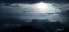
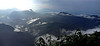

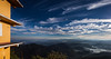

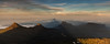
The above images may not be of the site on this page, but were taken nearby. They are loaded from Flickr so please click on them for image credits.
Click here to see more info for this site
Nearby sites
Click here to view sites on an interactive map of the areaKey: Red: member's photo, Blue: 3rd party photo, Yellow: other image, Green: no photo - please go there and take one, Grey: site destroyed
Download sites to:
KML (Google Earth)
GPX (GPS waypoints)
CSV (Garmin/Navman)
CSV (Excel)
To unlock full downloads you need to sign up as a Contributory Member. Otherwise downloads are limited to 50 sites.
Turn off the page maps and other distractions
Nearby sites listing. In the following links * = Image available
12.1km WSW 253° Batadomba Lena Cave Cave or Rock Shelter
36.0km WSW 240° Pahiyangala, Sri Lanka Cave or Rock Shelter
37.0km ENE 68° Seetha Amman Temple* Modern Stone Circle etc
57.9km E 85° Dowa Rajamaha Viharaya Ancient Temple
60.8km NNW 346° Gal Messa of Padavigampola* Burial Chamber or Dolmen
60.8km E 84° Ravana Ella Cave Cave or Rock Shelter
65.3km ESE 102° Buduruvagala* Sculptured Stone
66.6km ESE 101° Weherayaya Dagoba* Ancient Temple
80.7km SSE 161° Mulkirigala* Ancient Temple
82.4km SSE 155° Kasagala Vihara* Ancient Temple
84.4km SE 139° Karabagala Aranya Senasanaya Cave or Rock Shelter
87.3km E 94° Dematamal Viharaya* Ancient Temple
90.2km SSE 153° Kahandawa Purana Viharaya* Ancient Temple
94.5km E 95° Maligawila standing Buddha* Sculptured Stone
95.1km E 95° Dhambegoda Bodhisathwa Statue* Sculptured Stone
95.5km SE 146° Ussangoda* Natural Stone / Erratic / Other Natural Feature
97.1km N 10° Nalanda Gedige* Ancient Temple
98.8km SE 142° Gothapabbata Vihara* Ancient Temple
103.3km SE 124° Galkanumandiya Ruins* Ancient Temple
103.6km SE 124° Yatala Dagoba* Ancient Temple
105.3km SE 124° Tissamaharama Raja Maha Vihara Ancient Temple
105.5km SE 124° Building of the Silapassa Parivena Ancient Temple
105.6km ESE 124° Tissa Sandagiri Vihara Ancient Temple
113.1km E 86° Wattumbegoda cave Rock Art
113.6km SE 126° Kirinda Temple* Ancient Temple
View more nearby sites and additional images


 We would like to know more about this location. Please feel free to add a brief description and any relevant information in your own language.
 Wir möchten mehr über diese Stätte erfahren. Bitte zögern Sie nicht, eine kurze Beschreibung und relevante Informationen in Deutsch hinzuzufügen.
 Nous aimerions en savoir encore un peu sur les lieux. S'il vous plaît n'hesitez pas à ajouter une courte description et tous les renseignements pertinents dans votre propre langue.
 Quisieramos informarnos un poco más de las lugares. No dude en añadir una breve descripción y otros datos relevantes en su propio idioma.