

<< Text Pages >> Leistruper Wald Opferstein I - Natural Stone / Erratic / Other Natural Feature in Germany in North Rhine-Westphalia
Submitted by KaiHofmann on Tuesday, 15 December 2015 Page Views: 1356
Natural PlacesSite Name: Leistruper Wald Opferstein ICountry: Germany
NOTE: This site is 2.251 km away from the location you searched for.
Land: North Rhine-Westphalia Type: Natural Stone / Erratic / Other Natural Feature
Nearest Town: Detmold Nearest Village: Diestelbruch
Latitude: 51.927373N Longitude: 8.957938E
Condition:
| 5 | Perfect |
| 4 | Almost Perfect |
| 3 | Reasonable but with some damage |
| 2 | Ruined but still recognisable as an ancient site |
| 1 | Pretty much destroyed, possibly visible as crop marks |
| 0 | No data. |
| -1 | Completely destroyed |
| 5 | Superb |
| 4 | Good |
| 3 | Ordinary |
| 2 | Not Good |
| 1 | Awful |
| 0 | No data. |
| 5 | Can be driven to, probably with disabled access |
| 4 | Short walk on a footpath |
| 3 | Requiring a bit more of a walk |
| 2 | A long walk |
| 1 | In the middle of nowhere, a nightmare to find |
| 0 | No data. |
| 5 | co-ordinates taken by GPS or official recorded co-ordinates |
| 4 | co-ordinates scaled from a detailed map |
| 3 | co-ordinates scaled from a bad map |
| 2 | co-ordinates of the nearest village |
| 1 | co-ordinates of the nearest town |
| 0 | no data |
Internal Links:
External Links:
Rock Art in North Rhine-Westphalia
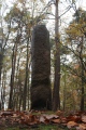
Stone boulder/s with human work traces like cup marks furrows etc. Some stones nearby are arranged in an alignment or in a horseshoe shaped array.
You may be viewing yesterday's version of this page. To see the most up to date information please register for a free account.
Do not use the above information on other web sites or publications without permission of the contributor.
Nearby Images from Flickr
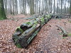
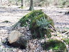
The above images may not be of the site on this page, but were taken nearby. They are loaded from Flickr so please click on them for image credits.
Click here to see more info for this site
Nearby sites
Click here to view sites on an interactive map of the areaKey: Red: member's photo, Blue: 3rd party photo, Yellow: other image, Green: no photo - please go there and take one, Grey: site destroyed
Download sites to:
KML (Google Earth)
GPX (GPS waypoints)
CSV (Garmin/Navman)
CSV (Excel)
To unlock full downloads you need to sign up as a Contributory Member. Otherwise downloads are limited to 50 sites.
Turn off the page maps and other distractions
Nearby sites listing. In the following links * = Image available
377m SE 134° Grabhügelgruppe Altehain Round Barrow(s)
525m SSE 154° Leistruper Wald Opferstein II Rock Art
573m S 182° Leistruper Wald Steinsetzung (III) Stone Row / Alignment
643m SSW 214° Leistruper Wald Hügelgrab* Cairn
673m SSW 196° Leistruper Wald Steinsetzung (II) Stone Row / Alignment
788m SSW 193° Leistruper Wald Steinsetzung (I)* Stone Row / Alignment
862m S 172° Leistruper Wald Steinsetzung (IV) Stone Row / Alignment
1.6km SE 136° Grabhügelgruppe Moerholz Round Barrow(s)
2.0km S 185° Grabhügel Im Ellern Round Barrow(s)
3.1km SSW 207° Grabhügelgruppe Bannenberg Round Barrow(s)
3.9km SW 221° Grabhügel Auf dem Osterberge Round Barrow(s)
4.2km WSW 243° Grabhügelgruppe Großer Schneiderbusch Round Barrow(s)
4.5km NW 314° Grabhügel Schlingenbusch Round Barrow(s)
5.1km WSW 248° Grabhügel Großer Stenderbusch Round Barrow(s)
5.4km SW 233° Grabhügel Im Wallberge Round Barrow(s)
5.6km WSW 248° Siedlungsplatz der mittleren Steinzeit Im Niedernkampe Ancient Village or Settlement
5.7km W 281° Lippisches Landesmuseum* Museum
5.9km W 261° Grabhügelgruppe Friedrichshöhe Barrow Cemetery
6.4km WSW 243° Grabhügelgruppe Recke Round Barrow(s)
6.4km W 262° Grabhügelgruppe Buchenberg Round Barrow(s)
7.1km SSW 203° Externsteine* Rock Outcrop
7.2km WSW 251° Grabhügelgruppe In der Steinbreite Barrow Cemetery
7.3km WNW 299° Eselstein* Natural Stone / Erratic / Other Natural Feature
7.6km WNW 298° Siedlungsplatz der älteren Steinzeit Mesche Ancient Village or Settlement
8.1km WSW 258° Wallburg Großer Hünenring* Hillfort
View more nearby sites and additional images


 We would like to know more about this location. Please feel free to add a brief description and any relevant information in your own language.
 Wir möchten mehr über diese Stätte erfahren. Bitte zögern Sie nicht, eine kurze Beschreibung und relevante Informationen in Deutsch hinzuzufügen.
 Nous aimerions en savoir encore un peu sur les lieux. S'il vous plaît n'hesitez pas à ajouter une courte description et tous les renseignements pertinents dans votre propre langue.
 Quisieramos informarnos un poco más de las lugares. No dude en añadir una breve descripción y otros datos relevantes en su propio idioma.