


<< Text Pages >> Marapela Nuraghe - Broch or Nuraghe in Italy in Sardinia (Sardegna)
Submitted by SolarMegalith on Tuesday, 15 February 2011 Page Views: 2346
Neolithic and Bronze AgeSite Name: Marapela NuragheCountry: Italy
NOTE: This site is 1.281 km away from the location you searched for.
Region: Sardinia (Sardegna) Type: Broch or Nuraghe
Nearest Village: Busachi
Latitude: 40.023342N Longitude: 8.891802E
Condition:
| 5 | Perfect |
| 4 | Almost Perfect |
| 3 | Reasonable but with some damage |
| 2 | Ruined but still recognisable as an ancient site |
| 1 | Pretty much destroyed, possibly visible as crop marks |
| 0 | No data. |
| -1 | Completely destroyed |
| 5 | Superb |
| 4 | Good |
| 3 | Ordinary |
| 2 | Not Good |
| 1 | Awful |
| 0 | No data. |
| 5 | Can be driven to, probably with disabled access |
| 4 | Short walk on a footpath |
| 3 | Requiring a bit more of a walk |
| 2 | A long walk |
| 1 | In the middle of nowhere, a nightmare to find |
| 0 | No data. |
| 5 | co-ordinates taken by GPS or official recorded co-ordinates |
| 4 | co-ordinates scaled from a detailed map |
| 3 | co-ordinates scaled from a bad map |
| 2 | co-ordinates of the nearest village |
| 1 | co-ordinates of the nearest town |
| 0 | no data |
Internal Links:
External Links:
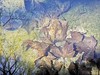
Nuraghe in Sardinia (Sardegna)
A Bronze Age nuraghe south of Busachi.
You may be viewing yesterday's version of this page. To see the most up to date information please register for a free account.
Do not use the above information on other web sites or publications without permission of the contributor.
Nearby Images from Flickr

The above images may not be of the site on this page, but were taken nearby. They are loaded from Flickr so please click on them for image credits.
Click here to see more info for this site
Nearby sites
Click here to view sites on an interactive map of the areaKey: Red: member's photo, Blue: 3rd party photo, Yellow: other image, Green: no photo - please go there and take one, Grey: site destroyed
Download sites to:
KML (Google Earth)
GPX (GPS waypoints)
CSV (Garmin/Navman)
CSV (Excel)
To unlock full downloads you need to sign up as a Contributory Member. Otherwise downloads are limited to 50 sites.
Turn off the page maps and other distractions
Nearby sites listing. In the following links * = Image available
591m W 261° Sa Giacca Protonuraghe Broch or Nuraghe
5.6km WSW 247° Putzola Protonuraghe Broch or Nuraghe
6.1km SSW 196° Arasseda Nuraghe Broch or Nuraghe
6.5km E 88° Pira 'e Zuri Nuraghe Broch or Nuraghe
7.0km S 175° Sa Mura Nuraghe (Samugheo) Broch or Nuraghe
7.5km NNW 339° Aune Nuraghe Broch or Nuraghe
7.5km E 88° Su Linnari Nuraghe Broch or Nuraghe
7.6km N 351° Trubeli Nuraghe* Broch or Nuraghe
7.7km N 353° Sas Perderas Domus de Janas* Rock Cut Tomb
7.8km WSW 237° Is Domigheddas Domus de Janas Rock Cut Tomb
8.2km NW 311° Cugutzu Nuraghe* Broch or Nuraghe
8.4km NNE 25° Monte Calighe Domus de Janas Rock Cut Tomb
8.6km WNW 286° Mura Olia Nuraghe* Broch or Nuraghe
9.0km NNW 334° Mura Odine Nuraghe Broch or Nuraghe
9.1km N 7° Su Monte Santuario Nuragico* Ancient Temple
9.2km SSE 153° Cuccuru e Lai* Sculptured Stone
9.2km NNE 16° Prunittu Domus de Janas* Rock Cut Tomb
9.4km N 10° Santu Cristos Domus de Janas* Rock Cut Tomb
9.9km WNW 291° Columbos Nuraghe (Paulilatino)* Broch or Nuraghe
10.1km NNE 31° S'Angrone Domus de Janas* Rock Cut Tomb
10.3km N 351° Spinosu Nuraghe Broch or Nuraghe
10.5km WNW 297° Abbaia Nuraghe Broch or Nuraghe
10.5km W 260° Pischina Andria Nuraghe* Broch or Nuraghe
10.8km WNW 294° Busauru Nuraghe* Broch or Nuraghe
11.2km ESE 116° Accoro Nuedda Nuraghe* Broch or Nuraghe
View more nearby sites and additional images


 We would like to know more about this location. Please feel free to add a brief description and any relevant information in your own language.
 Wir möchten mehr über diese Stätte erfahren. Bitte zögern Sie nicht, eine kurze Beschreibung und relevante Informationen in Deutsch hinzuzufügen.
 Nous aimerions en savoir encore un peu sur les lieux. S'il vous plaît n'hesitez pas à ajouter une courte description et tous les renseignements pertinents dans votre propre langue.
 Quisieramos informarnos un poco más de las lugares. No dude en añadir una breve descripción y otros datos relevantes en su propio idioma.