 with our Megalithic Portal iPhone app")


<< Our Photo Pages >> Mesadda Domus de Janas - Rock Cut Tomb in Italy in Sardinia (Sardegna)
Submitted by francescomanconi on Thursday, 04 January 2018 Page Views: 996
Multi-periodSite Name: Mesadda Domus de JanasCountry: Italy
NOTE: This site is 1.614 km away from the location you searched for.
Region: Sardinia (Sardegna) Type: Rock Cut Tomb
Nearest Town: Oristano Nearest Village: Ruinas
Latitude: 39.913933N Longitude: 8.894699E
Condition:
| 5 | Perfect |
| 4 | Almost Perfect |
| 3 | Reasonable but with some damage |
| 2 | Ruined but still recognisable as an ancient site |
| 1 | Pretty much destroyed, possibly visible as crop marks |
| 0 | No data. |
| -1 | Completely destroyed |
| 5 | Superb |
| 4 | Good |
| 3 | Ordinary |
| 2 | Not Good |
| 1 | Awful |
| 0 | No data. |
| 5 | Can be driven to, probably with disabled access |
| 4 | Short walk on a footpath |
| 3 | Requiring a bit more of a walk |
| 2 | A long walk |
| 1 | In the middle of nowhere, a nightmare to find |
| 0 | No data. |
| 5 | co-ordinates taken by GPS or official recorded co-ordinates |
| 4 | co-ordinates scaled from a detailed map |
| 3 | co-ordinates scaled from a bad map |
| 2 | co-ordinates of the nearest village |
| 1 | co-ordinates of the nearest town |
| 0 | no data |
Internal Links:
External Links:
")
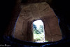
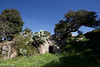
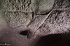
Near the village of Ruinas, in the region of Grighine, middle of Sardinia. It is a multi-cellular Tomb of particular interest, due to the presence of false windows, defined by grooves engraved with traces of red paint, of straight rafters in radial relief on the ceiling to evoke a wooden roof. In the main cell there is a small pillar, of which only the lower and upper parts are preserved with a symbol of the bull's head. Referable to the recent Neolithic.
You may be viewing yesterday's version of this page. To see the most up to date information please register for a free account.
")
")
Do not use the above information on other web sites or publications without permission of the contributor.
Nearby Images from Flickr

The above images may not be of the site on this page, but were taken nearby. They are loaded from Flickr so please click on them for image credits.
Click here to see more info for this site
Nearby sites
Click here to view sites on an interactive map of the areaKey: Red: member's photo, Blue: 3rd party photo, Yellow: other image, Green: no photo - please go there and take one, Grey: site destroyed
Download sites to:
KML (Google Earth)
GPX (GPS waypoints)
CSV (Garmin/Navman)
CSV (Excel)
To unlock full downloads you need to sign up as a Contributory Member. Otherwise downloads are limited to 50 sites.
Turn off the page maps and other distractions
Nearby sites listing. In the following links * = Image available
3.8km S 185° Baduggiana Standing Stone (Menhir)
4.3km S 182° Tuttiricchiu* Standing Stone (Menhir)
4.3km S 172° Is Forrus Domus de Janas* Rock Cut Tomb
4.3km S 173° Curru Tundu* Standing Stones
4.4km SSW 200° Friarosu Protonuraghe* Broch or Nuraghe
4.7km SSW 207° Bioranu Nuraghe* Broch or Nuraghe
4.8km SSE 156° Brentoni* Stone Row / Alignment
5.1km SSE 161° Cara Bassa* Stone Row / Alignment
5.2km N 4° Sa Mura Nuraghe (Samugheo) Broch or Nuraghe
5.5km NE 44° Cuccuru e Lai* Sculptured Stone
6.6km NNW 343° Arasseda Nuraghe Broch or Nuraghe
7.2km S 172° Genna Salixi Domus de Janas* Rock Cut Tomb
7.5km S 172° Caiu Nuraghe* Broch or Nuraghe
7.8km SE 140° Asuni Menhir* Standing Stones
8.3km S 169° Su Moguru Nuraghe* Broch or Nuraghe
8.5km SE 139° Is Cirquittus Circoli Megalitici* Stone Circle
8.6km SE 141° Is Cirquittus Stone row* Stone Row / Alignment
9.2km E 100° Orrubiu Nuraghe Broch or Nuraghe
10.3km E 98° Genna Corte Nuraghe* Broch or Nuraghe
10.4km ESE 101° Masone Perdu* Chambered Tomb
10.4km NW 319° Is Domigheddas Domus de Janas Rock Cut Tomb
10.7km ESE 102° Corte Noa Menhir I* Standing Stone (Menhir)
10.8km ESE 104° Corte Noa Stone row* Stone Row / Alignment
10.8km ESE 105° Perda Iddocca* Standing Stones
11.0km ESE 103° Corte Noa Dolmen* Burial Chamber or Dolmen
View more nearby sites and additional images


 We would like to know more about this location. Please feel free to add a brief description and any relevant information in your own language.
 Wir möchten mehr über diese Stätte erfahren. Bitte zögern Sie nicht, eine kurze Beschreibung und relevante Informationen in Deutsch hinzuzufügen.
 Nous aimerions en savoir encore un peu sur les lieux. S'il vous plaît n'hesitez pas à ajouter une courte description et tous les renseignements pertinents dans votre propre langue.
 Quisieramos informarnos un poco más de las lugares. No dude en añadir una breve descripción y otros datos relevantes en su propio idioma.