


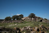
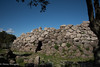
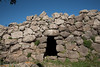
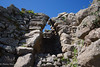
<< Our Photo Pages >> Pitzu Cummu Nuraghe - Broch or Nuraghe in Italy in Sardinia (Sardegna)
Submitted by SolarMegalith on Tuesday, 05 October 2010 Page Views: 3889
Neolithic and Bronze AgeSite Name: Pitzu Cummu NuragheCountry: Italy
NOTE: This site is 0.656 km away from the location you searched for.
Region: Sardinia (Sardegna) Type: Broch or Nuraghe
Nearest Town: Lunamatrona
Latitude: 39.647217N Longitude: 8.893239E
Condition:
| 5 | Perfect |
| 4 | Almost Perfect |
| 3 | Reasonable but with some damage |
| 2 | Ruined but still recognisable as an ancient site |
| 1 | Pretty much destroyed, possibly visible as crop marks |
| 0 | No data. |
| -1 | Completely destroyed |
| 5 | Superb |
| 4 | Good |
| 3 | Ordinary |
| 2 | Not Good |
| 1 | Awful |
| 0 | No data. |
| 5 | Can be driven to, probably with disabled access |
| 4 | Short walk on a footpath |
| 3 | Requiring a bit more of a walk |
| 2 | A long walk |
| 1 | In the middle of nowhere, a nightmare to find |
| 0 | No data. |
| 5 | co-ordinates taken by GPS or official recorded co-ordinates |
| 4 | co-ordinates scaled from a detailed map |
| 3 | co-ordinates scaled from a bad map |
| 2 | co-ordinates of the nearest village |
| 1 | co-ordinates of the nearest town |
| 0 | no data |
Internal Links:
External Links:
I have visited· I would like to visit
SolarMegalith visited on 7th Sep 2010 - their rating: Cond: 2 Amb: 4 Access: 4
")
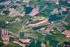
To visit Nuraghe Pitzu Cummu you can follow the road from Villanovaforru and turn right just before Nuraghe Trobas, or reach it from Lunamatrona - the hill with the nuraghe is located West of Parco Sa Turritta.
You may be viewing yesterday's version of this page. To see the most up to date information please register for a free account.
")
")
Do not use the above information on other web sites or publications without permission of the contributor.
Nearby Images from Flickr
The above images may not be of the site on this page, but were taken nearby. They are loaded from Flickr so please click on them for image credits.
Click here to see more info for this site
Nearby sites
Click here to view sites on an interactive map of the areaKey: Red: member's photo, Blue: 3rd party photo, Yellow: other image, Green: no photo - please go there and take one, Grey: site destroyed
Download sites to:
KML (Google Earth)
GPX (GPS waypoints)
CSV (Garmin/Navman)
CSV (Excel)
To unlock full downloads you need to sign up as a Contributory Member. Otherwise downloads are limited to 50 sites.
Turn off the page maps and other distractions
Nearby sites listing. In the following links * = Image available
1.2km W 268° Trobas Nuraghe* Broch or Nuraghe
1.2km WNW 285° Su Cuaddu 'e Nixias Tomba di Giganti* Chambered Tomb
1.9km W 271° Corti Marini Nuraghe Broch or Nuraghe
3.6km WSW 247° Genna Maria Nuraghe* Broch or Nuraghe
4.7km NNW 336° Sa Domu'e s'Orku Tomba di Giganti* Chambered Tomb
5.0km NNE 12° San Pietro Nuraghe (Ussaramanna)* Broch or Nuraghe
5.3km SSE 156° Corti Sa Pedra Pozzo Nuragico Holy Well or Sacred Spring
5.4km SSE 156° Corti Sa Pedra Nuraghe Broch or Nuraghe
5.6km NNE 23° Cabonu Nuraghe* Broch or Nuraghe
6.0km SE 145° Faurras Nuraghe Broch or Nuraghe
6.2km E 91° Moru Pintau Nuraghe* Broch or Nuraghe
6.9km NE 41° Su Sensu Nuraghe* Broch or Nuraghe
6.9km E 101° Santu Croxiu Nuraghe* Broch or Nuraghe
7.2km WSW 242° Santa Anastasia* Holy Well or Sacred Spring
7.5km W 268° Sedda sa Caudeba Tomba di Giganti B* Chambered Tomb
7.5km W 268° Sedda sa Caudeba Tomba di Giganti A* Chambered Tomb
7.7km W 270° Sartaro Nuraghe* Broch or Nuraghe
8.5km W 260° Serretzi Nuraghe Broch or Nuraghe
8.7km E 100° Su Mulinu Complesso Nuragico* Broch or Nuraghe
8.9km ENE 75° Ruinali Meseda Tomba di Giganti* Chambered Tomb
9.3km ENE 75° Mariga Nuraghe* Broch or Nuraghe
9.4km ESE 109° Cuccuru de Casteddu* Ancient Village or Settlement
9.8km ENE 72° Passiali Nuraghe* Broch or Nuraghe
9.9km ENE 75° Bruncu 'e Forru Nuraghe* Broch or Nuraghe
10.0km WSW 255° Santu Domini Nuraghe Broch or Nuraghe
View more nearby sites and additional images


 We would like to know more about this location. Please feel free to add a brief description and any relevant information in your own language.
 Wir möchten mehr über diese Stätte erfahren. Bitte zögern Sie nicht, eine kurze Beschreibung und relevante Informationen in Deutsch hinzuzufügen.
 Nous aimerions en savoir encore un peu sur les lieux. S'il vous plaît n'hesitez pas à ajouter une courte description et tous les renseignements pertinents dans votre propre langue.
 Quisieramos informarnos un poco más de las lugares. No dude en añadir una breve descripción y otros datos relevantes en su propio idioma.