


<< Text Pages >> Seewurt - Lüdingworth-Osterende II - Ancient Village or Settlement in Germany in Lower Saxony, Bremen
Submitted by Harald_Platta on Friday, 17 December 2021 Page Views: 261
Multi-periodSite Name: Seewurt - Lüdingworth-Osterende IICountry: Germany
NOTE: This site is 4.315 km away from the location you searched for.
Land: Lower Saxony, Bremen Type: Ancient Village or Settlement
Nearest Town: Cuxhaven Nearest Village: Lüdingworth
Latitude: 53.789781N Longitude: 8.830596E
Condition:
| 5 | Perfect |
| 4 | Almost Perfect |
| 3 | Reasonable but with some damage |
| 2 | Ruined but still recognisable as an ancient site |
| 1 | Pretty much destroyed, possibly visible as crop marks |
| 0 | No data. |
| -1 | Completely destroyed |
| 5 | Superb |
| 4 | Good |
| 3 | Ordinary |
| 2 | Not Good |
| 1 | Awful |
| 0 | No data. |
| 5 | Can be driven to, probably with disabled access |
| 4 | Short walk on a footpath |
| 3 | Requiring a bit more of a walk |
| 2 | A long walk |
| 1 | In the middle of nowhere, a nightmare to find |
| 0 | No data. |
| 5 | co-ordinates taken by GPS or official recorded co-ordinates |
| 4 | co-ordinates scaled from a detailed map |
| 3 | co-ordinates scaled from a bad map |
| 2 | co-ordinates of the nearest village |
| 1 | co-ordinates of the nearest town |
| 0 | no data |
Internal Links:
External Links:
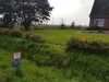
Seewurt - Lüdingworth-Osterende II is the mound of former terp settlement in Cuxhaven (Lower Saxony/Germany). Today, the central area of the terp measures 250 m x 150 m.
Reference:
Denkmalatlas Niedersachsen Objekt-ID: 28905237
You may be viewing yesterday's version of this page. To see the most up to date information please register for a free account.
Do not use the above information on other web sites or publications without permission of the contributor.
Nearby Images from Flickr

The above images may not be of the site on this page, but were taken nearby. They are loaded from Flickr so please click on them for image credits.
Click here to see more info for this site
Nearby sites
Click here to view sites on an interactive map of the areaKey: Red: member's photo, Blue: 3rd party photo, Yellow: other image, Green: no photo - please go there and take one, Grey: site destroyed
Download sites to:
KML (Google Earth)
GPX (GPS waypoints)
CSV (Garmin/Navman)
CSV (Excel)
To unlock full downloads you need to sign up as a Contributory Member. Otherwise downloads are limited to 50 sites.
Turn off the page maps and other distractions
Nearby sites listing. In the following links * = Image available
1.4km W 272° Seewurt - Lüdingworth-Osterende I Ancient Village or Settlement
4.0km W 279° Seewurt II -Lüdingworth-Ortsrand Ancient Village or Settlement
4.7km WNW 282° Seewurt I -Lüdingworth-Ortskern Ancient Village or Settlement
5.6km SSW 201° Wanna Steingrab (11b)* Chambered Tomb
6.1km SW 218° Graeberfeld von Westerwanna* Barrow Cemetery
6.1km SW 218° Wanna Gravenberg* Round Barrow(s)
6.2km SSW 212° Heimatmuseum Wanna* Museum
7.0km SW 223° Wanna Huegelgrab 6* Round Barrow(s)
7.1km SW 223° Wanna Huegelgrab 5* Round Barrow(s)
7.2km SW 226° Wanna Huegelgrab (7) Round Barrow(s)
7.4km SW 225° Wanna Huegelgrab 3* Round Barrow(s)
7.5km SW 225° Wanna Huegelgrab 2* Round Barrow(s)
7.5km SW 223° Wanna Huegelgrab 4* Round Barrow(s)
7.6km W 269° Kapellenwurt Lüderskoop I Ancient Village or Settlement
7.6km SW 225° Wanna Huegelgrab 1* Round Barrow(s)
7.6km SW 225° Wanna Steingrab (5)* Passage Grave
7.7km W 270° Kapellenwurt Lüderskoop II Ancient Village or Settlement
7.9km WSW 237° Wanna Steingrab (4)* Long Barrow
7.9km WSW 238° Wanna Steingrab (1)* Chambered Tomb
8.0km WSW 237° Wanna Steingrab (3)* Chambered Tomb
8.1km WSW 237° Wanna Steingrab (2)* Chambered Tomb
8.1km WSW 238° Wanna Steingrab (14)* Chambered Tomb
9.0km SW 232° Grabhügel Haveschenberg* Round Barrow(s)
9.4km SSW 196° Wanna Steingrab (8)* Chambered Tomb
9.4km SSW 196° Wanna Steingrab (9)* Chambered Tomb
View more nearby sites and additional images


 We would like to know more about this location. Please feel free to add a brief description and any relevant information in your own language.
 Wir möchten mehr über diese Stätte erfahren. Bitte zögern Sie nicht, eine kurze Beschreibung und relevante Informationen in Deutsch hinzuzufügen.
 Nous aimerions en savoir encore un peu sur les lieux. S'il vous plaît n'hesitez pas à ajouter une courte description et tous les renseignements pertinents dans votre propre langue.
 Quisieramos informarnos un poco más de las lugares. No dude en añadir una breve descripción y otros datos relevantes en su propio idioma.