

<< Our Photo Pages >> Wallburg Großer Hünenring - Hillfort in Germany in North Rhine-Westphalia
Submitted by Harald_Platta on Tuesday, 03 November 2015 Page Views: 1764
Iron Age and Later PrehistorySite Name: Wallburg Großer Hünenring Alternative Name: GrotenburgCountry: Germany
NOTE: This site is 0.227 km away from the location you searched for.
Land: North Rhine-Westphalia Type: Hillfort
Nearest Town: Detmold
Latitude: 51.912288N Longitude: 8.842592E
Condition:
| 5 | Perfect |
| 4 | Almost Perfect |
| 3 | Reasonable but with some damage |
| 2 | Ruined but still recognisable as an ancient site |
| 1 | Pretty much destroyed, possibly visible as crop marks |
| 0 | No data. |
| -1 | Completely destroyed |
| 5 | Superb |
| 4 | Good |
| 3 | Ordinary |
| 2 | Not Good |
| 1 | Awful |
| 0 | No data. |
| 5 | Can be driven to, probably with disabled access |
| 4 | Short walk on a footpath |
| 3 | Requiring a bit more of a walk |
| 2 | A long walk |
| 1 | In the middle of nowhere, a nightmare to find |
| 0 | No data. |
| 5 | co-ordinates taken by GPS or official recorded co-ordinates |
| 4 | co-ordinates scaled from a detailed map |
| 3 | co-ordinates scaled from a bad map |
| 2 | co-ordinates of the nearest village |
| 1 | co-ordinates of the nearest town |
| 0 | no data |
Internal Links:
External Links:
I have visited· I would like to visit
Harald_Platta visited on 2nd Mar 2013 - their rating: Cond: 2 Amb: 4 Access: 4
fornjotr have visited here
")
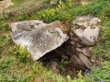
The hillfort measures 300 x 400 m and had a space of 11 ha. While most of the ramparts are preserved, no remains were found at the western part of the hill. Because this side of the hill is very steep, it was speculated that possibly this part had no ramparts at all.
The enclosure also included a well for the supply with fresh water. Several post holes were found inside of the enclosure, indicating the localization of houses.
Unfortunately, most of the interior space and parts of the ramparts were destroyed during the construction work for the Hermannsdenkmal (1838-1875). However, most of the ramparts are still visible today. Moreover, a part of the wooden palisade has been reconstructed.
The remains of the medieval hillfort Kleiner Hünenring are also preserved on Grotenburg hill (coordinates: 51.913440, 8.848750).
Literature:
[01] Teude, E.: Das Hermannsdenkmal und der Kleine und Große Hünenring. In: Ostwestfalen-Lippe. Ausflugsziele zwischen Detmold, Bielefeld und Porta Westfalica. Ausflüge zu Archäologie, Geschichte und Kultur in Deutschland 50 (2009).
[02] Hohenschwert, F.: Ur- und Frühgeschichtliche Befestigungen in Lippe. Lippische Studien, Bd. 4, (1978).
[03] Hölzermann, L.: Lokaluntersuchungen, die Kriege der Römer und Befestigungsmanieren der Germanen, Sachsen und des späteren Mittelalters betreffend (1878).
You may be viewing yesterday's version of this page. To see the most up to date information please register for a free account.
")
")
")
Do not use the above information on other web sites or publications without permission of the contributor.
Nearby Images from Flickr


The above images may not be of the site on this page, but were taken nearby. They are loaded from Flickr so please click on them for image credits.
Click here to see more info for this site
Nearby sites
Click here to view sites on an interactive map of the areaKey: Red: member's photo, Blue: 3rd party photo, Yellow: other image, Green: no photo - please go there and take one, Grey: site destroyed
Download sites to:
KML (Google Earth)
GPX (GPS waypoints)
CSV (Garmin/Navman)
CSV (Excel)
To unlock full downloads you need to sign up as a Contributory Member. Otherwise downloads are limited to 50 sites.
Turn off the page maps and other distractions
Nearby sites listing. In the following links * = Image available
801m WNW 294° Grabhügel Oberes Martsiek Round Barrow(s)
1.2km ESE 120° Grabhügelgruppe In der Steinbreite Barrow Cemetery
1.5km NW 309° Grabhügel Sternschanze Round Barrow(s)
1.8km ENE 62° Grabhügelgruppe Buchenberg Round Barrow(s)
2.2km ENE 70° Grabhügelgruppe Friedrichshöhe Barrow Cemetery
2.3km NNW 327° Grabhügelgruppe Bent Barrow Cemetery
2.4km N 354° Grabhügel Vietberg I Round Barrow(s)
2.5km ESE 118° Grabhügelgruppe Recke Round Barrow(s)
2.6km N 350° Grabhügelgruppe Vietberg* Round Barrow(s)
2.6km NW 306° Grabhügelgruppe Kahler Ehberg Round Barrow(s)
2.7km NNW 347° Grabhügel Vietberg II Round Barrow(s)
2.8km E 100° Siedlungsplatz der mittleren Steinzeit Im Niedernkampe Ancient Village or Settlement
3.0km WNW 300° Grabhügelgruppe Weginghauser Bruch* Barrow Cemetery
3.1km NW 305° Eisenquelle am Donoperteich Holy Well or Sacred Spring
3.2km NW 306° Grabhügelgruppe Eisenquelle Round Barrow(s)
3.2km E 95° Grabhügel Großer Stenderbusch Round Barrow(s)
3.5km NW 312° Grabhügelgruppe Hasselbraken Round Barrow(s)
3.6km WNW 303° Grabhügel Espenrekte Round Barrow(s)
3.6km NE 40° Lippisches Landesmuseum* Museum
3.9km WNW 296° Grabhügel Düsterngrund Round Barrow(s)
4.0km ESE 114° Grabhügel Im Wallberge Round Barrow(s)
4.2km E 93° Grabhügelgruppe Großer Schneiderbusch Round Barrow(s)
4.4km SSE 155° Grabhügel Berlebecker Heide Round Barrow(s)
5.1km WNW 295° Grabhügelgruppe Streitbrink Barrow Cemetery
5.3km NNE 13° Siedlungsplatz der älteren Steinzeit Mesche Ancient Village or Settlement
View more nearby sites and additional images


 We would like to know more about this location. Please feel free to add a brief description and any relevant information in your own language.
 Wir möchten mehr über diese Stätte erfahren. Bitte zögern Sie nicht, eine kurze Beschreibung und relevante Informationen in Deutsch hinzuzufügen.
 Nous aimerions en savoir encore un peu sur les lieux. S'il vous plaît n'hesitez pas à ajouter une courte description et tous les renseignements pertinents dans votre propre langue.
 Quisieramos informarnos un poco más de las lugares. No dude en añadir una breve descripción y otros datos relevantes en su propio idioma.