


<< Other Photo Pages >> Drakenhöhlen - Cave or Rock Shelter in Germany in North Rhine-Westphalia
Submitted by Harald_Platta on Saturday, 14 April 2018 Page Views: 1168
Multi-periodSite Name: Drakenhöhlen Alternative Name: DrachenhöhlenCountry: Germany
NOTE: This site is 1.243 km away from the location you searched for.
Land: North Rhine-Westphalia Type: Cave or Rock Shelter
Nearest Town: Obermarsberg
Latitude: 51.453568N Longitude: 8.850338E
Condition:
| 5 | Perfect |
| 4 | Almost Perfect |
| 3 | Reasonable but with some damage |
| 2 | Ruined but still recognisable as an ancient site |
| 1 | Pretty much destroyed, possibly visible as crop marks |
| 0 | No data. |
| -1 | Completely destroyed |
| 5 | Superb |
| 4 | Good |
| 3 | Ordinary |
| 2 | Not Good |
| 1 | Awful |
| 0 | No data. |
| 5 | Can be driven to, probably with disabled access |
| 4 | Short walk on a footpath |
| 3 | Requiring a bit more of a walk |
| 2 | A long walk |
| 1 | In the middle of nowhere, a nightmare to find |
| 0 | No data. |
| 5 | co-ordinates taken by GPS or official recorded co-ordinates |
| 4 | co-ordinates scaled from a detailed map |
| 3 | co-ordinates scaled from a bad map |
| 2 | co-ordinates of the nearest village |
| 1 | co-ordinates of the nearest town |
| 0 | no data |
Be the first person to rate this site - see the 'Contribute!' box in the right hand menu.
Internal Links:
External Links:
")
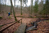
According to local legends, it is one of the places that claim to have been the site of the battle between Sigurd (Siegfried) and the dragon Fafnir.
The entrance of the caves can be seen but they are not allowed to be accessed.
Literature:
[01] Stadtmarketing Marsberg e.V.: Aussichts- und Kulturwanderweg.
[http://www.tourismus-marsberg.de/images/flyer/drakenhoehle.pdf]
You may be viewing yesterday's version of this page. To see the most up to date information please register for a free account.
Do not use the above information on other web sites or publications without permission of the contributor.
Nearby Images from Flickr

The above images may not be of the site on this page, but were taken nearby. They are loaded from Flickr so please click on them for image credits.
Click here to see more info for this site
Nearby sites
Click here to view sites on an interactive map of the areaKey: Red: member's photo, Blue: 3rd party photo, Yellow: other image, Green: no photo - please go there and take one, Grey: site destroyed
Download sites to:
KML (Google Earth)
GPX (GPS waypoints)
CSV (Garmin/Navman)
CSV (Excel)
To unlock full downloads you need to sign up as a Contributory Member. Otherwise downloads are limited to 50 sites.
Turn off the page maps and other distractions
Nearby sites listing. In the following links * = Image available
403m SSE 155° Eresburg* Hillfort
10.4km W 268° Madfeld Iron Age Settlement and Forge Ancient Village or Settlement
13.4km WSW 249° Hollenloch* Cave or Rock Shelter
13.4km NW 304° Wünnenberg Galeriegrab Chambered Tomb
13.8km SE 127° Summstein Arolsen Modern Stone Circle etc
15.9km N 351° Atteln 1* Chambered Tomb
15.9km NE 55° Kellberg Huegelgraeber (1)* Cairn
16.0km NE 38° Opferstein Hardehausen Natural Stone / Erratic / Other Natural Feature
16.5km N 349° Atteln Galeriegrab (2)* Burial Chamber or Dolmen
17.2km ENE 58° Weisses Holz Huegelgrab (1)* Cairn
17.3km ENE 58° Rimbeck* Passage Grave
17.4km ENE 58° Erdwerk von Rimbeck* Misc. Earthwork
17.5km NNW 340° Henglarn Steinkammergrab (2)* Chambered Tomb
18.1km NNW 340° Henglarn Galeriegrab 1* Chambered Tomb
18.5km NNE 23° Grabhügelfeld Bühlheimer Heide Barrow Cemetery
19.2km NNE 32° Kleiner Herrgott* Ancient Cross
19.5km NW 317° Wewelsburg Galeriegrab 2 Chambered Tomb
19.6km WSW 245° Summstein Hängeberg Modern Stone Circle etc
19.7km NNE 33° Behmburg* Hillfort
19.9km ENE 76° Warburg Galeriegrab (3)* Chambered Tomb
19.9km ENE 75° Warburg Galeriegrab (1)* Chambered Tomb
19.9km NNE 34° Opferstein am Hexenberg* Natural Stone / Erratic / Other Natural Feature
20.0km NNE 34° Drudenhöhle* Cave or Rock Shelter
20.0km NE 34° Opferstein Fauler Jäger* Natural Stone / Erratic / Other Natural Feature
20.0km ENE 76° Warburg Galeriegrab (5) Chambered Tomb
View more nearby sites and additional images


 We would like to know more about this location. Please feel free to add a brief description and any relevant information in your own language.
 Wir möchten mehr über diese Stätte erfahren. Bitte zögern Sie nicht, eine kurze Beschreibung und relevante Informationen in Deutsch hinzuzufügen.
 Nous aimerions en savoir encore un peu sur les lieux. S'il vous plaît n'hesitez pas à ajouter une courte description et tous les renseignements pertinents dans votre propre langue.
 Quisieramos informarnos un poco más de las lugares. No dude en añadir una breve descripción y otros datos relevantes en su propio idioma.