 with our Megalithic Portal iPhone app")


<< Our Photo Pages >> Santu Miali Nuraghe - Broch or Nuraghe in Italy in Sardinia (Sardegna)
Submitted by francescomanconi on Tuesday, 29 May 2012 Page Views: 2457
Neolithic and Bronze AgeSite Name: Santu Miali NuragheCountry: Italy
NOTE: This site is 0.897 km away from the location you searched for.
Region: Sardinia (Sardegna) Type: Broch or Nuraghe
Nearest Town: Oristano Nearest Village: Pompu
Latitude: 39.741111N Longitude: 8.797222E
Condition:
| 5 | Perfect |
| 4 | Almost Perfect |
| 3 | Reasonable but with some damage |
| 2 | Ruined but still recognisable as an ancient site |
| 1 | Pretty much destroyed, possibly visible as crop marks |
| 0 | No data. |
| -1 | Completely destroyed |
| 5 | Superb |
| 4 | Good |
| 3 | Ordinary |
| 2 | Not Good |
| 1 | Awful |
| 0 | No data. |
| 5 | Can be driven to, probably with disabled access |
| 4 | Short walk on a footpath |
| 3 | Requiring a bit more of a walk |
| 2 | A long walk |
| 1 | In the middle of nowhere, a nightmare to find |
| 0 | No data. |
| 5 | co-ordinates taken by GPS or official recorded co-ordinates |
| 4 | co-ordinates scaled from a detailed map |
| 3 | co-ordinates scaled from a bad map |
| 2 | co-ordinates of the nearest village |
| 1 | co-ordinates of the nearest town |
| 0 | no data |
Internal Links:
External Links:
I have visited· I would like to visit
43559959 would like to visit
")
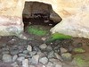
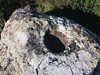
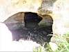
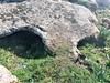
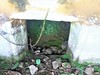
A great Nuragic construction consisting of large towers and a courtyard.
You may be viewing yesterday's version of this page. To see the most up to date information please register for a free account.
")
")
")
Do not use the above information on other web sites or publications without permission of the contributor.
Nearby Images from Flickr
The above images may not be of the site on this page, but were taken nearby. They are loaded from Flickr so please click on them for image credits.
Click here to see more info for this site
Nearby sites
Click here to view sites on an interactive map of the areaKey: Red: member's photo, Blue: 3rd party photo, Yellow: other image, Green: no photo - please go there and take one, Grey: site destroyed
Download sites to:
KML (Google Earth)
GPX (GPS waypoints)
CSV (Garmin/Navman)
CSV (Excel)
To unlock full downloads you need to sign up as a Contributory Member. Otherwise downloads are limited to 50 sites.
Turn off the page maps and other distractions
Nearby sites listing. In the following links * = Image available
992m NNE 33° Mandonis Nuraghe* Broch or Nuraghe
1.0km N 6° Prabanta Menhir* Standing Stone (Menhir)
2.1km NE 38° Barumele* Ancient Village or Settlement
2.7km WNW 295° Truncu 'e is Pillonis Nuraghe* Broch or Nuraghe
3.1km NW 305° Scab'e Cresia* Cave or Rock Shelter
3.8km WSW 241° Inus Nuraghe* Broch or Nuraghe
7.2km SSW 194° Su Gunventu Nuraghe* Broch or Nuraghe
7.3km NNW 343° Sennixeddu Stazione Preistorica Ancient Mine, Quarry or other Industry
7.4km WSW 245° S'Acqua Sa Baia Nuraghe Broch or Nuraghe
8.1km NE 51° Corona Arrubia Santuario Nuragico Ancient Temple
8.8km SE 134° Sa Domu'e s'Orku Tomba di Giganti* Chambered Tomb
9.0km S 191° Pala Merenza Nuraghe Broch or Nuraghe
9.3km WSW 237° Bentu 'e Crobis Nuraghe* Broch or Nuraghe
9.4km SW 232° Domu Beccia Nuraghe* Broch or Nuraghe
9.5km SSW 206° Cuccurada Nuraghe* Broch or Nuraghe
10.5km S 177° Sartaro Nuraghe* Broch or Nuraghe
10.7km S 176° Sedda sa Caudeba Tomba di Giganti B* Chambered Tomb
10.7km S 176° Sedda sa Caudeba Tomba di Giganti A* Chambered Tomb
10.8km ESE 121° San Pietro Nuraghe (Ussaramanna)* Broch or Nuraghe
11.7km ESE 117° Cabonu Nuraghe* Broch or Nuraghe
11.9km S 181° Serretzi Nuraghe Broch or Nuraghe
12.1km SSE 149° Corti Marini Nuraghe Broch or Nuraghe
12.3km ENE 57° Sa Cirra Nuraghe Broch or Nuraghe
12.3km SE 145° Su Cuaddu 'e Nixias Tomba di Giganti* Chambered Tomb
12.6km SE 146° Trobas Nuraghe* Broch or Nuraghe
View more nearby sites and additional images


 We would like to know more about this location. Please feel free to add a brief description and any relevant information in your own language.
 Wir möchten mehr über diese Stätte erfahren. Bitte zögern Sie nicht, eine kurze Beschreibung und relevante Informationen in Deutsch hinzuzufügen.
 Nous aimerions en savoir encore un peu sur les lieux. S'il vous plaît n'hesitez pas à ajouter une courte description et tous les renseignements pertinents dans votre propre langue.
 Quisieramos informarnos un poco más de las lugares. No dude en añadir una breve descripción y otros datos relevantes en su propio idioma.