 with our Megalithic Portal iPhone app")
, Aubrey Burl")
<< Our Photo Pages >> Darmstadt Steinkreis - Stone Circle in Germany in Hesse
Submitted by AlexHunger on Saturday, 08 October 2005 Page Views: 8817
Neolithic and Bronze AgeSite Name: Darmstadt SteinkreisCountry: Germany Land: Hesse Type: Stone Circle
Nearest Town: Darmstadt Nearest Village: Darmstadt
Latitude: 49.872336N Longitude: 8.727892E
Condition:
| 5 | Perfect |
| 4 | Almost Perfect |
| 3 | Reasonable but with some damage |
| 2 | Ruined but still recognisable as an ancient site |
| 1 | Pretty much destroyed, possibly visible as crop marks |
| 0 | No data. |
| -1 | Completely destroyed |
| 5 | Superb |
| 4 | Good |
| 3 | Ordinary |
| 2 | Not Good |
| 1 | Awful |
| 0 | No data. |
| 5 | Can be driven to, probably with disabled access |
| 4 | Short walk on a footpath |
| 3 | Requiring a bit more of a walk |
| 2 | A long walk |
| 1 | In the middle of nowhere, a nightmare to find |
| 0 | No data. |
| 5 | co-ordinates taken by GPS or official recorded co-ordinates |
| 4 | co-ordinates scaled from a detailed map |
| 3 | co-ordinates scaled from a bad map |
| 2 | co-ordinates of the nearest village |
| 1 | co-ordinates of the nearest town |
| 0 | no data |
Internal Links:
External Links:
")
IMPORTANT NOTE: Site believed to be near this position.
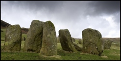
Cromlech consisting of 14 Large stones found in 1966, about 4 KM east of Darmstadt and 500 Meters north of B26 road at the edge of the forrest. It originaly consisted of 2 concentric circles
You may be viewing yesterday's version of this page. To see the most up to date information please register for a free account.
")
")
")
")
Do not use the above information on other web sites or publications without permission of the contributor.
Nearby Images from Flickr

The above images may not be of the site on this page, but were taken nearby. They are loaded from Flickr so please click on them for image credits.
Click here to see more info for this site
Nearby sites
Click here to view sites on an interactive map of the areaKey: Red: member's photo, Blue: 3rd party photo, Yellow: other image, Green: no photo - please go there and take one, Grey: site destroyed
Download sites to:
KML (Google Earth)
GPX (GPS waypoints)
CSV (Garmin/Navman)
CSV (Excel)
To unlock full downloads you need to sign up as a Contributory Member. Otherwise downloads are limited to 50 sites.
Turn off the page maps and other distractions
Nearby sites listing. In the following links * = Image available
4.9km W 270° Hinkelstein Darmstadt Natural Stone / Erratic / Other Natural Feature
10.1km SSW 206° Summstein Mühltal Modern Stone Circle etc
13.4km SE 139° Wersau Menhir* Standing Stone (Menhir)
14.9km ENE 78° Stein Klein-Umstadt Standing Stone (Menhir)
16.4km SSW 209° Alsbach Hinkelstein* Standing Stone (Menhir)
21.3km N 353° Alter Hegwald Barrow Cemetery
22.1km N 354° Rainheeg Grabhügelgruppe Barrow Cemetery
22.5km N 350° Heidenstock Grabhügelgruppe Barrow Cemetery
22.9km SSW 198° Bensheim Menhir* Standing Stone (Menhir)
24.3km NNW 349° Eichlehen Grabhügelgruppe Barrow Cemetery
24.6km NNW 346° Summstein Niederrad* Modern Stone Circle etc
26.2km SSE 166° Summstein Hammelbach Modern Stone Circle etc
26.6km N 352° Frankfurt Archaelogisches Museum* Museum
26.6km N 352° Frankfurt Museum für Vor-und Frühgeschichte Museum
28.0km W 270° Nierstein Menhir* Standing Stone (Menhir)
28.7km W 279° Der Lange Stein Nackenheim* Standing Stone (Menhir)
29.6km W 265° Dexheim Dicker Stein* Standing Stone (Menhir)
30.6km WNW 286° Laubenheimer Stein* Standing Stone (Menhir)
32.0km SW 221° Sackstein Bürstadt Standing Stone (Menhir)
32.4km NW 320° Grauer Stein Kapellenberg* Natural Stone / Erratic / Other Natural Feature
32.7km NW 321° Grabhügel Kapellenberg* Round Barrow(s)
32.7km NW 321° Kapellenberg Hofheim* Hillfort
33.1km ENE 69° Summstein Grünbrücke* Modern Stone Circle etc
34.3km NNW 338° Summstein Eschborn Modern Stone Circle etc
34.5km W 270° Selzen Menhir* Standing Stone (Menhir)
View more nearby sites and additional images


 We would like to know more about this location. Please feel free to add a brief description and any relevant information in your own language.
 Wir möchten mehr über diese Stätte erfahren. Bitte zögern Sie nicht, eine kurze Beschreibung und relevante Informationen in Deutsch hinzuzufügen.
 Nous aimerions en savoir encore un peu sur les lieux. S'il vous plaît n'hesitez pas à ajouter une courte description et tous les renseignements pertinents dans votre propre langue.
 Quisieramos informarnos un poco más de las lugares. No dude en añadir una breve descripción y otros datos relevantes en su propio idioma.