


<< Our Photo Pages >> Aidu Tomba di Giganti - Chambered Tomb in Italy in Sardinia (Sardegna)
Submitted by SolarMegalith on Saturday, 12 March 2022 Page Views: 340
Neolithic and Bronze AgeSite Name: Aidu Tomba di Giganti Alternative Name: Tomba di giganti AiduCountry: Italy Region: Sardinia (Sardegna) Type: Chambered Tomb
Nearest Town: Cossoine
Latitude: 40.437555N Longitude: 8.706043E
Condition:
| 5 | Perfect |
| 4 | Almost Perfect |
| 3 | Reasonable but with some damage |
| 2 | Ruined but still recognisable as an ancient site |
| 1 | Pretty much destroyed, possibly visible as crop marks |
| 0 | No data. |
| -1 | Completely destroyed |
| 5 | Superb |
| 4 | Good |
| 3 | Ordinary |
| 2 | Not Good |
| 1 | Awful |
| 0 | No data. |
| 5 | Can be driven to, probably with disabled access |
| 4 | Short walk on a footpath |
| 3 | Requiring a bit more of a walk |
| 2 | A long walk |
| 1 | In the middle of nowhere, a nightmare to find |
| 0 | No data. |
| 5 | co-ordinates taken by GPS or official recorded co-ordinates |
| 4 | co-ordinates scaled from a detailed map |
| 3 | co-ordinates scaled from a bad map |
| 2 | co-ordinates of the nearest village |
| 1 | co-ordinates of the nearest town |
| 0 | no data |
Internal Links:
External Links:
I have visited· I would like to visit
SolarMegalith visited on 21st Jun 2021 - their rating: Cond: 3 Amb: 4 Access: 4
")
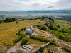
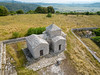
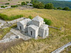
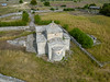
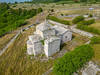
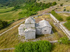
The Giants' Tomb of Aidu is a Nuragic megalithic tomb located south of the nuraghe of the same name. The elongated burial chamber (roughly West-East orientation) with some of the capstones survived, as well as part of the exedra. Two phases of construction can be distinguished in the tomb - in the second one the rectilinear exedra was transformed into a curvilinear one.
You may be viewing yesterday's version of this page. To see the most up to date information please register for a free account.
")
")
Do not use the above information on other web sites or publications without permission of the contributor.
Nearby Images from Flickr
The above images may not be of the site on this page, but were taken nearby. They are loaded from Flickr so please click on them for image credits.
Click here to see more info for this site
Nearby sites
Click here to view sites on an interactive map of the areaKey: Red: member's photo, Blue: 3rd party photo, Yellow: other image, Green: no photo - please go there and take one, Grey: site destroyed
Download sites to:
KML (Google Earth)
GPX (GPS waypoints)
CSV (Garmin/Navman)
CSV (Excel)
To unlock full downloads you need to sign up as a Contributory Member. Otherwise downloads are limited to 50 sites.
Turn off the page maps and other distractions
Nearby sites listing. In the following links * = Image available
155m N 9° Aidu Nuraghe* Broch or Nuraghe
921m SW 227° Alvu Nuraghe (Cossoine)* Broch or Nuraghe
927m W 275° Sos Iscaleddos Nuraghe Broch or Nuraghe
2.5km SE 131° Addanas Tomba di Giganti Chambered Tomb
3.6km SSW 211° Alvu Nuraghe (Pozzomaggiore)* Broch or Nuraghe
3.7km SSW 194° Androniga Domus de Janas Rock Cut Tomb
4.7km SSW 200° Giorzi Protonuraghe Broch or Nuraghe
5.3km NNE 23° Branca Domus de Janas* Rock Cut Tomb
5.5km SSW 210° Ruggiu Nuraghe* Broch or Nuraghe
5.7km NNE 22° Moseddu Domus de Janas* Rock Cut Tomb
5.8km SSE 148° S'Iscala 'e Pedra Nuraghe* Broch or Nuraghe
6.1km WSW 243° Tomasu Nuraghe* Broch or Nuraghe
6.6km SW 224° Cae Nuraghe* Broch or Nuraghe
6.6km NE 47° Mura Coloras Nuraghe* Broch or Nuraghe
6.7km E 98° Ena Leperes Nuraghe Broch or Nuraghe
6.9km WSW 250° Catadolzos Nuraghe* Broch or Nuraghe
6.9km WSW 250° Coladorzos Protonuraghe* Broch or Nuraghe
7.4km ENE 77° Campu de Olta Nuraghe Broch or Nuraghe
7.6km NE 50° Oes Nuraghe* Broch or Nuraghe
7.7km NE 45° Santu Antine Villaggio Nuragico* Ancient Village or Settlement
7.7km NE 45° Santu Antine Nuraghe* Broch or Nuraghe
8.4km NE 50° Fraigas Nuraghe* Broch or Nuraghe
8.4km N 9° Coroneddu Nuraghe Broch or Nuraghe
8.7km NE 50° Longu Nuraghe (Torralba)* Broch or Nuraghe
8.7km NE 48° Culzu Nuraghe* Broch or Nuraghe
View more nearby sites and additional images


 We would like to know more about this location. Please feel free to add a brief description and any relevant information in your own language.
 Wir möchten mehr über diese Stätte erfahren. Bitte zögern Sie nicht, eine kurze Beschreibung und relevante Informationen in Deutsch hinzuzufügen.
 Nous aimerions en savoir encore un peu sur les lieux. S'il vous plaît n'hesitez pas à ajouter une courte description et tous les renseignements pertinents dans votre propre langue.
 Quisieramos informarnos un poco más de las lugares. No dude en añadir una breve descripción y otros datos relevantes en su propio idioma.