<< Our Photo Pages >> Wallburg Tönsberg - Hillfort in Germany in North Rhine-Westphalia
Submitted by Harald_Platta on Thursday, 24 September 2015 Page Views: 2165
Multi-periodSite Name: Wallburg Tönsberg Alternative Name: SachsenlagerCountry: Germany
NOTE: This site is 7.088 km away from the location you searched for.
Land: North Rhine-Westphalia Type: Hillfort
Nearest Town: Oerlinghausen Nearest Village:
Latitude: 51.948383N Longitude: 8.692091E
Condition:
| 5 | Perfect |
| 4 | Almost Perfect |
| 3 | Reasonable but with some damage |
| 2 | Ruined but still recognisable as an ancient site |
| 1 | Pretty much destroyed, possibly visible as crop marks |
| 0 | No data. |
| -1 | Completely destroyed |
| 5 | Superb |
| 4 | Good |
| 3 | Ordinary |
| 2 | Not Good |
| 1 | Awful |
| 0 | No data. |
| 5 | Can be driven to, probably with disabled access |
| 4 | Short walk on a footpath |
| 3 | Requiring a bit more of a walk |
| 2 | A long walk |
| 1 | In the middle of nowhere, a nightmare to find |
| 0 | No data. |
| 5 | co-ordinates taken by GPS or official recorded co-ordinates |
| 4 | co-ordinates scaled from a detailed map |
| 3 | co-ordinates scaled from a bad map |
| 2 | co-ordinates of the nearest village |
| 1 | co-ordinates of the nearest town |
| 0 | no data |
Internal Links:
External Links:

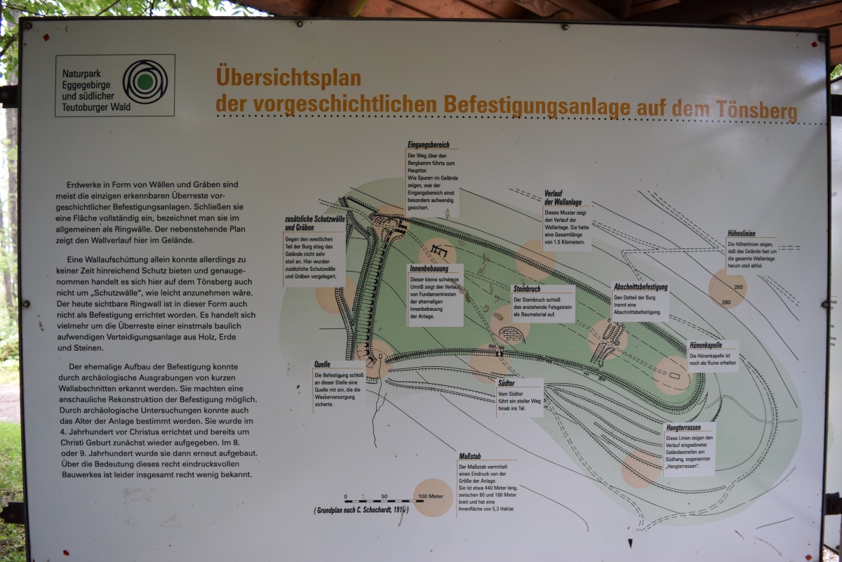
The hillfort is located on Tönsberg hill and allows a good overview on the surrounding landscape and former trading routes, that would lead to Münster, Paderborn, Lemgo or Hameln. Especially the neighboring pass via the south-east slope at Wistinghauser canyon has been of importance for a long time.
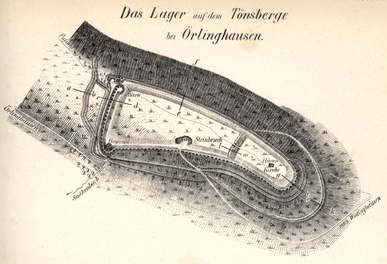
The hillford includes a total area of 15 hectares, while the main rampart is about 7 hectares. The fortifications consisted of earthen walls, wooden structures and dry stone walls. The system was destroyed and rebuilt several times. The southern slope exhibits several terraces, which were the basis for a settlement. No traces of a settlement were found on the climatically unfavorable north side.
After the transfer of the trading route from the Wistinghauser canyon to the north-west slope, the Wallburg Tönsberg lost its importance and was finally left in 850 AD.
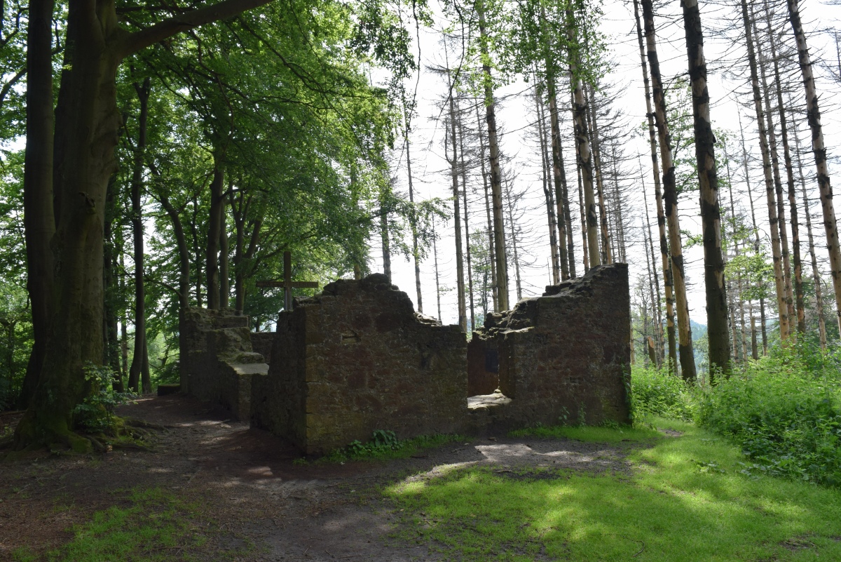
Today, several parts of the ramparts are still visible. Moreover, this area includes the ruins of an early medieval church, namely Antoniuskapelle or, alternatively, Hünenkapelle. It is assumed, that the original church was built by the Franks after they had conquered the Wallburg Tönsberg from the Saxons. The site is supposed to be place of the former pagan Saxon sanctuary. After the church was destroyed in 1548, the original cross was brought to Paderborn. In 1953, a wooden cross was set up in the ruins of the church by the Catholic congregation. Since then, the cross has been damaged several times by neo-pagan groups.
The reconstruction of a part of the Wallburg Tönsberg wall can be seen in the nearby open air museum Freilichtmuseum Oerlinghausen.
Literature:
[01] Treude, E.: Die eisenzeitliche Befestigung auf dem Tönsberg bei Oerlinghausen. In: Westfalen in der Eisenzeit (2015).
[02] Bérenger, D. & Treude, E.: Die Wallburg auf dem Tönsberg bei Oerlinghausen, Kreis Lippe. In: Frühe Burgen in Westfalen. Heft 27 (2008).
[03] Fischer, M. (Red.): Die Wallburg auf dem Tönsberg. In: LWL Presse- und Öffentlichkeitsarbeit – Mitteilung 07.02.08 (2008).
[04] Lass, C.: Zeichen des Widerspruchs. Warum neuheidnische Gruppen zur Hünenkapelle auf den Tönsberg pilgern. In: Neue Westfälische. Nr. 180 (2006)
[05] Diekmann, H.: Cheruskerhof mit Tönsbergburg zu Oerlinghausen (1967).
[06] Hölzermann, H.: Lokaluntersuchungen, die Kriege der Römer und Befestigungsmanieren der Germanen, Sachsen und des späteren Mittelalters betreffend (1878).
You may be viewing yesterday's version of this page. To see the most up to date information please register for a free account.


Do not use the above information on other web sites or publications without permission of the contributor.
Nearby Images from Flickr


The above images may not be of the site on this page, but were taken nearby. They are loaded from Flickr so please click on them for image credits.
Click here to see more info for this site
Nearby sites
Click here to view sites on an interactive map of the areaKey: Red: member's photo, Blue: 3rd party photo, Yellow: other image, Green: no photo - please go there and take one, Grey: site destroyed
Download sites to:
KML (Google Earth)
GPX (GPS waypoints)
CSV (Garmin/Navman)
CSV (Excel)
To unlock full downloads you need to sign up as a Contributory Member. Otherwise downloads are limited to 50 sites.
Turn off the page maps and other distractions
Nearby sites listing. In the following links * = Image available
2.0km W 278° Archäologisches Freilichtmuseum Oerlinghausen* Museum
5.4km ESE 112° Grabhügelgruppe Hörster Sprunge Barrow Cemetery
5.4km ESE 110° Rethlager Quellen* Holy Well or Sacred Spring
5.4km ESE 110° Hoppeckequelle* Holy Well or Sacred Spring
6.0km ESE 108° Grabhügelgruppe Streitbrink Barrow Cemetery
7.2km ESE 109° Grabhügel Düsterngrund Round Barrow(s)
7.6km ESE 106° Grabhügel Espenrekte Round Barrow(s)
7.9km ESE 102° Grabhügelgruppe Hasselbraken Round Barrow(s)
8.0km ESE 105° Grabhügelgruppe Eisenquelle Round Barrow(s)
8.1km ESE 106° Eisenquelle am Donoperteich Holy Well or Sacred Spring
8.1km ESE 108° Grabhügelgruppe Weginghauser Bruch* Barrow Cemetery
8.6km ESE 107° Grabhügelgruppe Kahler Ehberg Round Barrow(s)
8.7km ENE 67° Johannissteine bei Lage* Natural Stone / Erratic / Other Natural Feature
9.3km ESE 103° Grabhügelgruppe Bent Barrow Cemetery
9.7km ESE 109° Grabhügel Sternschanze Round Barrow(s)
9.8km E 98° Grabhügel Vietberg II Round Barrow(s)
10.0km E 98° Grabhügelgruppe Vietberg* Round Barrow(s)
10.2km E 99° Grabhügel Vietberg I Round Barrow(s)
10.3km ESE 111° Grabhügel Oberes Martsiek Round Barrow(s)
10.8km NW 309° Sieker Iron Age Settlement Ancient Village or Settlement
11.1km ESE 111° Wallburg Großer Hünenring* Hillfort
11.6km E 84° Siedlungsplatz der älteren Steinzeit Mesche Ancient Village or Settlement
11.9km E 84° Eselstein* Natural Stone / Erratic / Other Natural Feature
12.3km ESE 112° Grabhügelgruppe In der Steinbreite Barrow Cemetery
12.3km ESE 105° Grabhügelgruppe Buchenberg Round Barrow(s)
View more nearby sites and additional images


 We would like to know more about this location. Please feel free to add a brief description and any relevant information in your own language.
 Wir möchten mehr über diese Stätte erfahren. Bitte zögern Sie nicht, eine kurze Beschreibung und relevante Informationen in Deutsch hinzuzufügen.
 Nous aimerions en savoir encore un peu sur les lieux. S'il vous plaît n'hesitez pas à ajouter une courte description et tous les renseignements pertinents dans votre propre langue.
 Quisieramos informarnos un poco más de las lugares. No dude en añadir una breve descripción y otros datos relevantes en su propio idioma.