


<< Other Photo Pages >> Opferstein Vierenberg - Natural Stone / Erratic / Other Natural Feature in Germany in North Rhine-Westphalia
Submitted by KaiHofmann on Thursday, 15 May 2014 Page Views: 1630
Natural PlacesSite Name: Opferstein Vierenberg Alternative Name: Altar Stone VierenbergCountry: Germany
NOTE: This site is 7.298 km away from the location you searched for.
Land: North Rhine-Westphalia Type: Natural Stone / Erratic / Other Natural Feature
Nearest Town: Bad Salzuflen Nearest Village: Wüsten
Latitude: 52.090223N Longitude: 8.794737E
Condition:
| 5 | Perfect |
| 4 | Almost Perfect |
| 3 | Reasonable but with some damage |
| 2 | Ruined but still recognisable as an ancient site |
| 1 | Pretty much destroyed, possibly visible as crop marks |
| 0 | No data. |
| -1 | Completely destroyed |
| 5 | Superb |
| 4 | Good |
| 3 | Ordinary |
| 2 | Not Good |
| 1 | Awful |
| 0 | No data. |
| 5 | Can be driven to, probably with disabled access |
| 4 | Short walk on a footpath |
| 3 | Requiring a bit more of a walk |
| 2 | A long walk |
| 1 | In the middle of nowhere, a nightmare to find |
| 0 | No data. |
| 5 | co-ordinates taken by GPS or official recorded co-ordinates |
| 4 | co-ordinates scaled from a detailed map |
| 3 | co-ordinates scaled from a bad map |
| 2 | co-ordinates of the nearest village |
| 1 | co-ordinates of the nearest town |
| 0 | no data |
Internal Links:
External Links:
I have visited· I would like to visit
Harald_Platta has visited here
")
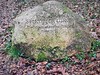
A boulder with an artificially smoothed surface. The stone is called "Opferstein" in english "altar stone".
You may be viewing yesterday's version of this page. To see the most up to date information please register for a free account.
Do not use the above information on other web sites or publications without permission of the contributor.
Nearby Images from Flickr

The above images may not be of the site on this page, but were taken nearby. They are loaded from Flickr so please click on them for image credits.
Click here to see more info for this site
Nearby sites
Click here to view sites on an interactive map of the areaKey: Red: member's photo, Blue: 3rd party photo, Yellow: other image, Green: no photo - please go there and take one, Grey: site destroyed
Download sites to:
KML (Google Earth)
GPX (GPS waypoints)
CSV (Garmin/Navman)
CSV (Excel)
To unlock full downloads you need to sign up as a Contributory Member. Otherwise downloads are limited to 50 sites.
Turn off the page maps and other distractions
Nearby sites listing. In the following links * = Image available
3.8km NNE 19° Hünengrab Schalks Busch Round Barrow(s)
12.1km ENE 57° Grabhügelgruppe Haiberg* Barrow Cemetery
12.5km S 175° Johannissteine bei Lage* Natural Stone / Erratic / Other Natural Feature
13.0km ESE 114° Wallburg Piepenkopf* Hillfort
13.8km ESE 110° Wallburg Amelungsburg (Lipper Bergland)* Hillfort
14.0km N 355° Werste Steinkammergrab* Passage Grave
15.3km SSE 163° Siedlungsplatz der älteren Steinzeit Mesche Ancient Village or Settlement
15.4km SSE 162° Eselstein* Natural Stone / Erratic / Other Natural Feature
16.4km ENE 61° Schäferstein Stemmen* Standing Stone (Menhir)
17.0km WNW 289° Widukind Museum* Museum
17.0km SSE 152° Grabhügel Schlingenbusch Round Barrow(s)
17.3km SSW 204° Wallburg Tönsberg* Hillfort
17.4km S 171° Grabhügel Vietberg II Round Barrow(s)
17.4km S 178° Grabhügelgruppe Hasselbraken Round Barrow(s)
17.5km S 171° Grabhügelgruppe Vietberg* Round Barrow(s)
17.6km S 170° Grabhügel Vietberg I Round Barrow(s)
17.7km S 184° Grabhügelgruppe Streitbrink Barrow Cemetery
17.8km S 186° Rethlager Quellen* Holy Well or Sacred Spring
17.8km S 186° Hoppeckequelle* Holy Well or Sacred Spring
17.8km WSW 240° Sieker Iron Age Settlement Ancient Village or Settlement
17.8km E 84° Summstein Extertal Modern Stone Circle etc
17.8km S 179° Grabhügel Espenrekte Round Barrow(s)
17.9km SSW 210° Archäologisches Freilichtmuseum Oerlinghausen* Museum
17.9km SSE 162° Lippisches Landesmuseum* Museum
17.9km S 178° Grabhügelgruppe Eisenquelle Round Barrow(s)
View more nearby sites and additional images


 We would like to know more about this location. Please feel free to add a brief description and any relevant information in your own language.
 Wir möchten mehr über diese Stätte erfahren. Bitte zögern Sie nicht, eine kurze Beschreibung und relevante Informationen in Deutsch hinzuzufügen.
 Nous aimerions en savoir encore un peu sur les lieux. S'il vous plaît n'hesitez pas à ajouter une courte description et tous les renseignements pertinents dans votre propre langue.
 Quisieramos informarnos un poco más de las lugares. No dude en añadir una breve descripción y otros datos relevantes en su propio idioma.