


<< Our Photo Pages >> S'Omu 'e s'Orku Nuraghe - Broch or Nuraghe in Italy in Sardinia (Sardegna)
Submitted by francescomanconi on Sunday, 19 August 2012 Page Views: 2999
Neolithic and Bronze AgeSite Name: S'Omu 'e s'Orku Nuraghe Alternative Name: Sa Domu 'de s'OrkuCountry: Italy
NOTE: This site is 3.487 km away from the location you searched for.
Region: Sardinia (Sardegna) Type: Broch or Nuraghe
Nearest Town: Iglesias Nearest Village: Domusnovas
Latitude: 39.323611N Longitude: 8.640000E
Condition:
| 5 | Perfect |
| 4 | Almost Perfect |
| 3 | Reasonable but with some damage |
| 2 | Ruined but still recognisable as an ancient site |
| 1 | Pretty much destroyed, possibly visible as crop marks |
| 0 | No data. |
| -1 | Completely destroyed |
| 5 | Superb |
| 4 | Good |
| 3 | Ordinary |
| 2 | Not Good |
| 1 | Awful |
| 0 | No data. |
| 5 | Can be driven to, probably with disabled access |
| 4 | Short walk on a footpath |
| 3 | Requiring a bit more of a walk |
| 2 | A long walk |
| 1 | In the middle of nowhere, a nightmare to find |
| 0 | No data. |
| 5 | co-ordinates taken by GPS or official recorded co-ordinates |
| 4 | co-ordinates scaled from a detailed map |
| 3 | co-ordinates scaled from a bad map |
| 2 | co-ordinates of the nearest village |
| 1 | co-ordinates of the nearest town |
| 0 | no data |
Internal Links:
External Links:
")
The complex consists of a main tower, originally included in a trilobate bastion. A barbican including five towers surrounds the main building. Some remains suggest the presence of a village around the nuraghe.
The bastion is 17 m in length (north-south) x 12.40 wide (east-west), well preserved in the east-northeast, with a maximum height of 7 m.
The complex may be dated to 1600-1000 BC.
You may be viewing yesterday's version of this page. To see the most up to date information please register for a free account.
")
")
")
Do not use the above information on other web sites or publications without permission of the contributor.
Nearby Images from Flickr
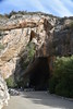
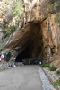
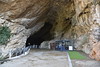
The above images may not be of the site on this page, but were taken nearby. They are loaded from Flickr so please click on them for image credits.
Click here to see more info for this site
Nearby sites
Click here to view sites on an interactive map of the areaKey: Red: member's photo, Blue: 3rd party photo, Yellow: other image, Green: no photo - please go there and take one, Grey: site destroyed
Download sites to:
KML (Google Earth)
GPX (GPS waypoints)
CSV (Garmin/Navman)
CSV (Excel)
To unlock full downloads you need to sign up as a Contributory Member. Otherwise downloads are limited to 50 sites.
Turn off the page maps and other distractions
Nearby sites listing. In the following links * = Image available
6.2km S 185° Santu Pauli Nuraghe* Broch or Nuraghe
6.8km NE 40° Matzanni* Holy Well or Sacred Spring
14.3km WNW 303° Tempio di Antas* Ancient Temple
17.0km ENE 58° Monte Zippiri Nuraghe* Broch or Nuraghe
17.4km E 82° Casteddu de Fanaris Complesso Nuragico* Broch or Nuraghe
17.4km E 83° Fundali Fanaris de Jossu Nuraghe* Broch or Nuraghe
18.2km S 180° Pesus Nuraghe* Broch or Nuraghe
18.4km S 191° Sitzia Nuraghe Broch or Nuraghe
19.0km E 93° Monte Idda Nuraghe* Broch or Nuraghe
19.3km SW 232° Corona Maria Tomba di Giganti Chambered Tomb
19.5km S 186° Sa Idda Nuraghe* Broch or Nuraghe
20.1km SSW 208° Cannas di Sotto Domus de Janas* Rock Cut Tomb
20.3km WSW 246° Seruci Nuraghe* Broch or Nuraghe
20.3km N 355° San Cosimo Nuraghe* Broch or Nuraghe
20.4km N 354° San Cosimo Tomba di Giganti* Chambered Tomb
20.4km SSW 209° Museo Archeologico Villa Sulcis* Museum
20.6km SSE 161° Pranedda Domus de Janas* Rock Cut Tomb
20.7km SSE 160° Ega Is Marsinis Nuraghe* Broch or Nuraghe
20.7km WSW 238° Is Arenas Pozzo Sacro* Holy Well or Sacred Spring
20.7km SW 220° Monte Sirai Ancient Village or Settlement
21.1km SW 216° Sirai Nuraghe* Broch or Nuraghe
21.3km S 173° Montessu Necropolis* Rock Cut Tomb
21.4km S 173° Corona Sa Figu Nuraghe* Broch or Nuraghe
21.4km S 175° Su Angioni Nuraghe* Broch or Nuraghe
21.7km SSW 207° Sa Turri Nuraghe* Broch or Nuraghe
View more nearby sites and additional images


 We would like to know more about this location. Please feel free to add a brief description and any relevant information in your own language.
 Wir möchten mehr über diese Stätte erfahren. Bitte zögern Sie nicht, eine kurze Beschreibung und relevante Informationen in Deutsch hinzuzufügen.
 Nous aimerions en savoir encore un peu sur les lieux. S'il vous plaît n'hesitez pas à ajouter une courte description et tous les renseignements pertinents dans votre propre langue.
 Quisieramos informarnos un poco más de las lugares. No dude en añadir una breve descripción y otros datos relevantes en su propio idioma.