 with our Megalithic Portal iPhone app")


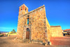
<< Our Photo Pages >> Santu Pauli Nuraghe - Broch or Nuraghe in Italy in Sardinia (Sardegna)
Submitted by SolarMegalith on Thursday, 04 April 2024 Page Views: 28
Neolithic and Bronze AgeSite Name: Santu Pauli NuragheCountry: Italy
NOTE: This site is 1.658 km away from the location you searched for.
Region: Sardinia (Sardegna) Type: Broch or Nuraghe
Nearest Town: Villamassargia
Latitude: 39.268443N Longitude: 8.634262E
Condition:
| 5 | Perfect |
| 4 | Almost Perfect |
| 3 | Reasonable but with some damage |
| 2 | Ruined but still recognisable as an ancient site |
| 1 | Pretty much destroyed, possibly visible as crop marks |
| 0 | No data. |
| -1 | Completely destroyed |
| 5 | Superb |
| 4 | Good |
| 3 | Ordinary |
| 2 | Not Good |
| 1 | Awful |
| 0 | No data. |
| 5 | Can be driven to, probably with disabled access |
| 4 | Short walk on a footpath |
| 3 | Requiring a bit more of a walk |
| 2 | A long walk |
| 1 | In the middle of nowhere, a nightmare to find |
| 0 | No data. |
| 5 | co-ordinates taken by GPS or official recorded co-ordinates |
| 4 | co-ordinates scaled from a detailed map |
| 3 | co-ordinates scaled from a bad map |
| 2 | co-ordinates of the nearest village |
| 1 | co-ordinates of the nearest town |
| 0 | no data |
Internal Links:
External Links:
I have visited· I would like to visit
SolarMegalith visited on 26th Mar 2023 - their rating: Cond: 2 Amb: 4 Access: 4
")
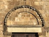
Nuraghe Santu Pauli is located on a low hill immediately SW of Villamassargia. It is an example of nuraghe a tancato - a complex nuraghe with two towers and a small courtyard between them. Chambers in both towers partially survived, the courtyard is distinguishable as well.
Reerence:
G. Canino (1998). Archaeological survey in the Villamassargia territory (Cagliari-Sardinia) in "Papers from the EAA Third Annual Meeting at Ravenna 1997 Volume III: Sardinia". Oxford: BAR, p. 115-120.
You may be viewing yesterday's version of this page. To see the most up to date information please register for a free account.
")
")
")
")
Do not use the above information on other web sites or publications without permission of the contributor.
Nearby Images from Flickr
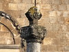
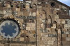
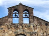
The above images may not be of the site on this page, but were taken nearby. They are loaded from Flickr so please click on them for image credits.
Click here to see more info for this site
Nearby sites
Click here to view sites on an interactive map of the areaKey: Red: member's photo, Blue: 3rd party photo, Yellow: other image, Green: no photo - please go there and take one, Grey: site destroyed
Download sites to:
KML (Google Earth)
GPX (GPS waypoints)
CSV (Garmin/Navman)
CSV (Excel)
To unlock full downloads you need to sign up as a Contributory Member. Otherwise downloads are limited to 50 sites.
Turn off the page maps and other distractions
Nearby sites listing. In the following links * = Image available
6.2km N 5° S'Omu 'e s'Orku Nuraghe* Broch or Nuraghe
12.1km S 178° Pesus Nuraghe* Broch or Nuraghe
12.3km NNE 23° Matzanni* Holy Well or Sacred Spring
12.3km SSW 195° Sitzia Nuraghe Broch or Nuraghe
13.4km S 186° Sa Idda Nuraghe* Broch or Nuraghe
14.7km SW 217° Cannas di Sotto Domus de Janas* Rock Cut Tomb
15.0km SW 219° Museo Archeologico Villa Sulcis* Museum
15.2km SSE 152° Pranedda Domus de Janas* Rock Cut Tomb
15.3km SSE 151° Ega Is Marsinis Nuraghe* Broch or Nuraghe
15.3km S 169° Montessu Necropolis* Rock Cut Tomb
15.4km S 171° Su Angioni Nuraghe* Broch or Nuraghe
15.4km SSE 168° Corona Sa Figu Nuraghe* Broch or Nuraghe
15.8km WSW 249° Corona Maria Tomba di Giganti Chambered Tomb
16.1km SW 232° Monte Sirai Ancient Village or Settlement
16.2km SW 227° Sirai Nuraghe* Broch or Nuraghe
16.2km SW 215° Sa Turri Nuraghe* Broch or Nuraghe
17.4km SW 231° Piliu Nuraghe Broch or Nuraghe
17.7km WSW 254° Is Arenas Pozzo Sacro* Holy Well or Sacred Spring
17.9km S 170° S'Arriorgiu Nuraghe* Broch or Nuraghe
18.0km SSE 149° Tattinu Pozzo Sacro* Holy Well or Sacred Spring
18.0km SSE 150° Tattinu Villaggio Nuragico* Ancient Village or Settlement
18.1km NW 320° Tempio di Antas* Ancient Temple
18.1km S 172° Niedda Nuraghe Broch or Nuraghe
18.2km W 263° Seruci Nuraghe* Broch or Nuraghe
18.2km S 170° Is Pedras Crocadas Menhirs* Stone Row / Alignment
View more nearby sites and additional images


 We would like to know more about this location. Please feel free to add a brief description and any relevant information in your own language.
 Wir möchten mehr über diese Stätte erfahren. Bitte zögern Sie nicht, eine kurze Beschreibung und relevante Informationen in Deutsch hinzuzufügen.
 Nous aimerions en savoir encore un peu sur les lieux. S'il vous plaît n'hesitez pas à ajouter une courte description et tous les renseignements pertinents dans votre propre langue.
 Quisieramos informarnos un poco más de las lugares. No dude en añadir una breve descripción y otros datos relevantes en su propio idioma.