


<< Other Photo Pages >> Babilonie - Hillfort in Germany in North Rhine-Westphalia
Submitted by Harald_Platta on Thursday, 29 October 2015 Page Views: 1574
Iron Age and Later PrehistorySite Name: BabilonieCountry: Germany
NOTE: This site is 5.649 km away from the location you searched for.
Land: North Rhine-Westphalia Type: Hillfort
Nearest Town: Lübbecke
Latitude: 52.276718N Longitude: 8.576678E
Condition:
| 5 | Perfect |
| 4 | Almost Perfect |
| 3 | Reasonable but with some damage |
| 2 | Ruined but still recognisable as an ancient site |
| 1 | Pretty much destroyed, possibly visible as crop marks |
| 0 | No data. |
| -1 | Completely destroyed |
| 5 | Superb |
| 4 | Good |
| 3 | Ordinary |
| 2 | Not Good |
| 1 | Awful |
| 0 | No data. |
| 5 | Can be driven to, probably with disabled access |
| 4 | Short walk on a footpath |
| 3 | Requiring a bit more of a walk |
| 2 | A long walk |
| 1 | In the middle of nowhere, a nightmare to find |
| 0 | No data. |
| 5 | co-ordinates taken by GPS or official recorded co-ordinates |
| 4 | co-ordinates scaled from a detailed map |
| 3 | co-ordinates scaled from a bad map |
| 2 | co-ordinates of the nearest village |
| 1 | co-ordinates of the nearest town |
| 0 | no data |
Internal Links:
External Links:
")
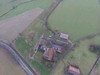
Babilonie is a Germanic-derived word and can be translated as "up in the woods“. The hillfort is situated on the northern edge of the Wiehengebirge hills and represents a wedge-shaped, double-rampart system. The ramparts were fortified with a palisade. The entire enclosure has a size of 12 hectares.
According to a legend, the hillfort was reused by the Saxon leader Wittekind during the Saxon-Frankish period.
Today, the ramparts are still relatively well preserved.
References:
[01] Berenger, D.: Die Babilonie im Norden von Ostwestfalen. In: Westalen in der Eisenzeit (2015).
[02] Capelle, T.: Wallburgen in Westfalen-Lippe. In: Frühe Burgen in Westfalen Sonderband 1 (2010).
[03] Sicherl, B.: Eisenzeitliche Befestigungen in Westfalen. Die Forschungen des vergangenen Jahrzentsund Ansätze einer religiösen Gliederung. In: Keltische Einflüsse im nördlichen Mitteleuropa während der mittleren und jüngeren vorrömischen Eisenzeit (2007)
[04] Bérenger, D.: Die Wallburg Babilonie, Stadt Lübbecke, Kreis Minden-Lübbecke. In: Frühe Burgen in Westfalen Bd. 12 (1997).
[05] Glüsing, P.: Zwei wichtige Neufunde der älteren Eisenzeit aus dem Bereich der früheren Nienburg Gruppe. In: Zu Einflüssen der Hallstattkultur auf die frühe Eisenzeit im nördlichen Nordwestdeutschland. Offa 36 (1979).
[06] Schmidt, H.: Die Babilonie in Geschichte und Sage. In: 1000 Jahre Gemeinde Blasheim (1969).
[07] Schuchardt, C: Atlas vorgeschichtlicher Befestigungen in Niedersachsen (1916).
[08] Höfer, P.: Der Feldzug des Germanicus im Jahre 16. n.Chr. (1884).
You may be viewing yesterday's version of this page. To see the most up to date information please register for a free account.
")
Do not use the above information on other web sites or publications without permission of the contributor.
Nearby Images from Flickr


The above images may not be of the site on this page, but were taken nearby. They are loaded from Flickr so please click on them for image credits.
Click here to see more info for this site
Nearby sites
Click here to view sites on an interactive map of the areaKey: Red: member's photo, Blue: 3rd party photo, Yellow: other image, Green: no photo - please go there and take one, Grey: site destroyed
Download sites to:
KML (Google Earth)
GPX (GPS waypoints)
CSV (Garmin/Navman)
CSV (Excel)
To unlock full downloads you need to sign up as a Contributory Member. Otherwise downloads are limited to 50 sites.
Turn off the page maps and other distractions
Nearby sites listing. In the following links * = Image available
4.5km ENE 62° Wittekindsquelle Lübbecke* Holy Well or Sacred Spring
12.7km ENE 74° Moorfundplatz Unterlübbe Ancient Trackway
13.4km E 94° Wittekindsquelle Bergkirchen* Holy Well or Sacred Spring
15.2km ESE 116° Werste Steinkammergrab* Passage Grave
15.3km S 184° Widukind Museum* Museum
17.1km NW 313° Bohmte Hügelgrab Round Barrow(s)
18.3km NNE 28° Großer Stein von Tonnenheide* Natural Stone / Erratic / Other Natural Feature
18.7km W 275° Deitinghausen Grosssteingrab* Burial Chamber or Dolmen
18.8km W 275° Grambergen Opferstein* Natural Stone / Erratic / Other Natural Feature
19.5km W 277° Krevinghausen Steingrab 1* Chambered Tomb
19.7km E 99° Wallburg Dehmer Burg* Hillfort
21.0km E 99° Wittekindsquelle (Porta Westfalica)* Holy Well or Sacred Spring
21.0km W 277° Krevinghausen Steingrab 3 Chambered Tomb
21.1km NNW 333° Grabhügel Stemweder Berg Round Barrow(s)
21.1km NNE 21° Grabhügel Wehe Round Barrow(s)
21.2km E 99° Wallburg Wittekindsburg (Barkhausen)* Hillfort
21.7km W 277° Krevinghausen Steingrab 2 Chambered Tomb
21.8km WNW 295° Herringhausen Hügelgräberfeld Barrow Cemetery
23.0km WNW 286° Caldenhof Steingrab* Chambered Tomb
23.4km W 277° Wulften Steingrab 2 und 3 Chambered Tomb
23.5km SE 137° Hünengrab Schalks Busch Round Barrow(s)
24.8km W 279° Wulften Steingrab 1 Chambered Tomb
25.5km SE 144° Opferstein Vierenberg* Natural Stone / Erratic / Other Natural Feature
25.6km W 270° Jeggen Grosssteingrab* Burial Chamber or Dolmen
25.8km W 279° Slopsteine* Burial Chamber or Dolmen
View more nearby sites and additional images


 We would like to know more about this location. Please feel free to add a brief description and any relevant information in your own language.
 Wir möchten mehr über diese Stätte erfahren. Bitte zögern Sie nicht, eine kurze Beschreibung und relevante Informationen in Deutsch hinzuzufügen.
 Nous aimerions en savoir encore un peu sur les lieux. S'il vous plaît n'hesitez pas à ajouter une courte description et tous les renseignements pertinents dans votre propre langue.
 Quisieramos informarnos un poco más de las lugares. No dude en añadir una breve descripción y otros datos relevantes en su propio idioma.