


<< Our Photo Pages >> Tennenbronn Hinkelstein - Standing Stone (Menhir) in Germany in Baden-Wuerttemberg
Submitted by AlexHunger on Tuesday, 13 September 2005 Page Views: 3757
Neolithic and Bronze AgeSite Name: Tennenbronn HinkelsteinCountry: Germany
NOTE: This site is 2.868 km away from the location you searched for.
Land: Baden-Wuerttemberg Type: Standing Stone (Menhir)
Nearest Town: Freiburg Nearest Village: Tennenbronn
Latitude: 48.196620N Longitude: 8.377750E
Condition:
| 5 | Perfect |
| 4 | Almost Perfect |
| 3 | Reasonable but with some damage |
| 2 | Ruined but still recognisable as an ancient site |
| 1 | Pretty much destroyed, possibly visible as crop marks |
| 0 | No data. |
| -1 | Completely destroyed |
| 5 | Superb |
| 4 | Good |
| 3 | Ordinary |
| 2 | Not Good |
| 1 | Awful |
| 0 | No data. |
| 5 | Can be driven to, probably with disabled access |
| 4 | Short walk on a footpath |
| 3 | Requiring a bit more of a walk |
| 2 | A long walk |
| 1 | In the middle of nowhere, a nightmare to find |
| 0 | No data. |
| 5 | co-ordinates taken by GPS or official recorded co-ordinates |
| 4 | co-ordinates scaled from a detailed map |
| 3 | co-ordinates scaled from a bad map |
| 2 | co-ordinates of the nearest village |
| 1 | co-ordinates of the nearest town |
| 0 | no data |
Internal Links:
External Links:
")
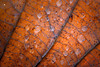
Large reddish limestone block with cup hole on front in fields on side of a hill.
You may be viewing yesterday's version of this page. To see the most up to date information please register for a free account.
")
")
Do not use the above information on other web sites or publications without permission of the contributor.
Nearby Images from Flickr

The above images may not be of the site on this page, but were taken nearby. They are loaded from Flickr so please click on them for image credits.
Click here to see more info for this site
Nearby sites
Click here to view sites on an interactive map of the areaKey: Red: member's photo, Blue: 3rd party photo, Yellow: other image, Green: no photo - please go there and take one, Grey: site destroyed
Download sites to:
KML (Google Earth)
GPX (GPS waypoints)
CSV (Garmin/Navman)
CSV (Excel)
To unlock full downloads you need to sign up as a Contributory Member. Otherwise downloads are limited to 50 sites.
Turn off the page maps and other distractions
Nearby sites listing. In the following links * = Image available
9.4km WSW 246° Schalensteine Gremmelsbach* Rock Art
10.2km SE 145° Judenbühl Grabhügel Round Barrow(s)
14.1km WSW 248° Summstein Schonach* Modern Stone Circle etc
14.6km WSW 246° Schalensteinpfad Schonach* Sculptured Stone
15.9km ENE 57° Oberndorf Keltische Viereckschanze Ancient Village or Settlement
16.0km E 93° Eichwald Grabhügelgruppe Barrow Cemetery
16.3km SSE 159° Franziskanermuseum Museum
17.0km SE 126° Kehlwald Grabhügelgruppe Barrow Cemetery
17.6km SSE 164° Magdalenenbergle* Round Barrow(s)
19.5km SE 144° Schwenningen Grabhügelgruppe Barrow Cemetery
20.0km S 172° Eggwald Grabhügelgruppe Barrow Cemetery
22.0km NE 39° Sulz am Neckar Grabhügelgruppe Barrow Cemetery
22.0km NE 39° Sulz am Neckar Keltische Viereckschanze Ancient Village or Settlement
23.8km E 85° Heidenstädtle Keltische Viereckschanze Ancient Village or Settlement
23.8km E 86° Kohlplätzle Keltische Viereckschanze Ancient Village or Settlement
27.2km NW 318° Summstein Oberharmersbach Modern Stone Circle etc
27.2km NW 307° Summstein am Egelwaldweg Modern Stone Circle etc
27.4km ESE 120° Sheerers Allmand Keltische Viereckschanze Ancient Village or Settlement
27.4km ESE 120° Steinerden Bruck Höhensiedlung Ancient Village or Settlement
27.6km E 86° Schömberg Grabhügelfeld Barrow Cemetery
27.7km ESE 120° Steinerden Bruck Grabhügelgruppe Barrow Cemetery
28.2km SSE 156° Oberer Schiessbühl Grabhügelgruppe Barrow Cemetery
28.5km SSE 156° Unterer Schiessbühl Grabhügelgruppe Barrow Cemetery
28.8km SE 131° Zeugenberg Vorgeschichtlich Siedlung Ancient Village or Settlement
29.9km SSE 154° Buckhäule Grabhügelgruppe Barrow Cemetery
View more nearby sites and additional images


 We would like to know more about this location. Please feel free to add a brief description and any relevant information in your own language.
 Wir möchten mehr über diese Stätte erfahren. Bitte zögern Sie nicht, eine kurze Beschreibung und relevante Informationen in Deutsch hinzuzufügen.
 Nous aimerions en savoir encore un peu sur les lieux. S'il vous plaît n'hesitez pas à ajouter une courte description et tous les renseignements pertinents dans votre propre langue.
 Quisieramos informarnos un poco más de las lugares. No dude en añadir una breve descripción y otros datos relevantes en su propio idioma.