

<< Our Photo Pages >> Le Lille Nuraghe - Broch or Nuraghe in Italy in Sardinia (Sardegna)
Submitted by SolarMegalith on Wednesday, 11 May 2016 Page Views: 1129
Neolithic and Bronze AgeSite Name: Le Lille NuragheCountry: Italy Region: Sardinia (Sardegna) Type: Broch or Nuraghe
Nearest Town: Carloforte
Latitude: 39.114650N Longitude: 8.297398E
Condition:
| 5 | Perfect |
| 4 | Almost Perfect |
| 3 | Reasonable but with some damage |
| 2 | Ruined but still recognisable as an ancient site |
| 1 | Pretty much destroyed, possibly visible as crop marks |
| 0 | No data. |
| -1 | Completely destroyed |
| 5 | Superb |
| 4 | Good |
| 3 | Ordinary |
| 2 | Not Good |
| 1 | Awful |
| 0 | No data. |
| 5 | Can be driven to, probably with disabled access |
| 4 | Short walk on a footpath |
| 3 | Requiring a bit more of a walk |
| 2 | A long walk |
| 1 | In the middle of nowhere, a nightmare to find |
| 0 | No data. |
| 5 | co-ordinates taken by GPS or official recorded co-ordinates |
| 4 | co-ordinates scaled from a detailed map |
| 3 | co-ordinates scaled from a bad map |
| 2 | co-ordinates of the nearest village |
| 1 | co-ordinates of the nearest town |
| 0 | no data |
Internal Links:
External Links:
I have visited· I would like to visit
SolarMegalith visited on 19th Apr 2016 - their rating: Cond: 2 Amb: 4 Access: 4
")
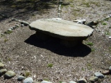
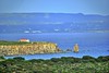
Nuraghe Le Lille is located on the top of a hill in the eastern part of San Pietro island. Remains of the collapsed tholos chamber are still distinguishable, the outer wall-face is in best condition in the southern part of the tower.
You may be viewing yesterday's version of this page. To see the most up to date information please register for a free account.
")
")
")
")
Do not use the above information on other web sites or publications without permission of the contributor.
Nearby Images from Flickr
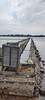
The above images may not be of the site on this page, but were taken nearby. They are loaded from Flickr so please click on them for image credits.
Click here to see more info for this site
Nearby sites
Click here to view sites on an interactive map of the areaKey: Red: member's photo, Blue: 3rd party photo, Yellow: other image, Green: no photo - please go there and take one, Grey: site destroyed
Download sites to:
KML (Google Earth)
GPX (GPS waypoints)
CSV (Garmin/Navman)
CSV (Excel)
To unlock full downloads you need to sign up as a Contributory Member. Otherwise downloads are limited to 50 sites.
Turn off the page maps and other distractions
Nearby sites listing. In the following links * = Image available
1.9km NNW 348° Laveria Nuraghe* Broch or Nuraghe
3.3km WNW 298° Bricco del Polpo Nuraghe* Broch or Nuraghe
5.6km NW 315° Papassina Nuraghe* Broch or Nuraghe
12.3km SSE 148° Cala Lunga Nuraghe Broch or Nuraghe
12.4km ESE 121° Noccus Nuraghe Broch or Nuraghe
12.4km ESE 121° Is Noccus Tomba di Giganti Chambered Tomb
12.5km ESE 122° Su Cuccu de Bogalatti Nuraghe Broch or Nuraghe
13.5km SE 134° Chirigu Nuraghe* Broch or Nuraghe
13.9km SE 139° Corongiu Murvonis Complesso Nuragico* Broch or Nuraghe
16.5km NE 39° Ghilotta Nuraghe* Broch or Nuraghe
16.6km SSE 147° Su Niu 'e su Crobu Tomba di Giganti* Chambered Tomb
16.6km ESE 105° Su Para e Sa Mongia* Standing Stones
16.7km ENE 68° Piliu Nuraghe Broch or Nuraghe
16.7km E 87° Punta Gannau Nuraghe* Broch or Nuraghe
16.8km SE 139° Cannai Pozzo Nuragico* Holy Well or Sacred Spring
16.8km E 88° Locci Santus Domus de Janas* Rock Cut Tomb
17.0km SE 139° Feminedda Nuraghe* Broch or Nuraghe
17.1km NE 45° Is Arenas Pozzo Sacro* Holy Well or Sacred Spring
17.2km SE 142° Monte s'Orxiu Nuraghe* Broch or Nuraghe
17.6km SSE 148° Grutti Acqua Pozzo Sacro* Holy Well or Sacred Spring
17.7km SSE 147° Grutti Acqua Pozzo Nuragico* Holy Well or Sacred Spring
17.7km SSE 147° Grutti Acqua Villaggio Nuragico* Ancient Village or Settlement
17.7km SSE 147° Grutti Acqua Nuraghe* Broch or Nuraghe
17.7km SE 135° S'Ega Marteddu Nuraghe* Broch or Nuraghe
17.8km SSE 147° Grutti Acqua Bacino Nuragico* Holy Well or Sacred Spring
View more nearby sites and additional images


 We would like to know more about this location. Please feel free to add a brief description and any relevant information in your own language.
 Wir möchten mehr über diese Stätte erfahren. Bitte zögern Sie nicht, eine kurze Beschreibung und relevante Informationen in Deutsch hinzuzufügen.
 Nous aimerions en savoir encore un peu sur les lieux. S'il vous plaît n'hesitez pas à ajouter une courte description et tous les renseignements pertinents dans votre propre langue.
 Quisieramos informarnos un poco más de las lugares. No dude en añadir una breve descripción y otros datos relevantes en su propio idioma.